TopoQuest Logo
Do you find TopoQuest useful?
Help keep TopoQuest running and adding new maps/features by donating!
Bitcoin:  19c7KJd3qBynnjoSw5npx9KScwjBe4ifkT
Litecoin:  LXs6TkuXGGXo1vDsWCkWVdjQX94eUKd6ui
Home View Maps Find Maps Find Places Resources & Links


Chattoogaville, Georgia Topographic Map

USGS Map Title: Chattoogaville, GA
USGS Map MRC: 34085C4
DRG (GeoTIFF) Download: o34085c4.tif


Neighboring USGS Topographic Map Quads:


  Jamestown, AL  
34085D5
 

  Lyerly, GA  
34085D4
 

  Summerville, GA  
34085D3
 

  Gaylesville, AL  
34085C5
 

  Chattoogaville, GA  
34085C4
 

  Rock Mountain, GA  
34085C3
 

  Cedar Bluff, AL  
34085B5
 

  Melson, GA  
34085B4
 

  Livingston, GA  
34085B3


Map MRC Location:

N35°
W86°
N35°
W85°
H8 H7 H6 H5 H4 H3 H2 H1
G8 G7 G6 G5 G4 G3 G2 G1
F8 F7 F6 F5 F4 F3 F2 F1
E8 E7 E6 E5 E4 E3 E2 E1
D8 D7 D6 D5 D4 D3 D2 D1
C8 C7 C6 C5 C4 C3 C2 C1
B8 B7 B6 B5 B4 B3 B2 B1
A8 A7 A6 A5 A4 A3 A2 A1
N34°
W86°
N34°
W85°

Chattoogaville, GA USGS 1:24K Topographic Map Preview:
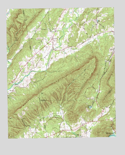
Chattoogaville, GA USGS Topographic Map
Click on map above to begin viewing in our Map Viewer.

This topographic map contains these locations and features:
Feature Name Type Latitude Longitude GNIS ID View Map
Back ValleyValleyN34.3253°W85.4963°113325View Map
Back Valley RidgeRidgeN34.3567°W85.4783°113326View Map
Bakers PondLakeN34.2934°W85.4610°310748View Map
Bogan MountainRidgeN34.2931°W85.4641°114650View Map
Bogan MountainSummitN34.2981°W85.4547°354800View Map
Bogan PeakSummitN34.2695°W85.4986°114651View Map
Carr CemeteryCemeteryN34.2737°W85.4352°353565View Map
Carr MountainSummitN34.2693°W85.4472°331326View Map
Cedar Springs (historical)Populated PlaceN34.3051°W85.4933°136855View Map
Cedar Springs ChurchChurchN34.3665°W85.3944°312500View Map
ChattoogavillePopulated PlaceN34.3451°W85.4469°326219View Map
Chattoogaville Volunteer Fire DepartmentBuildingN34.3545°W85.4432°2604291View Map
Coon CreekStreamN34.2656°W85.3972°312941View Map
Finley ChapelChurchN34.3459°W85.4027°314128View Map
FullertonPopulated PlaceN34.2962°W85.4933°118752View Map
Game Farm PondReservoirN34.2792°W85.4041°314500View Map
Game Farm Pond DamDamN34.2790°W85.4033°339643View Map
Hall ValleyPopulated PlaceN34.2556°W85.4694°136904View Map
Hall ValleyValleyN34.2541°W85.4233°356143View Map
Heath MountainSummitN34.2523°W85.3897°315291View Map
Hinton CreekStreamN34.3379°W85.4397°328169View Map
Holland CemeteryCemeteryN34.3387°W85.4291°344456View Map
Indian CemeteryCemeteryN34.2584°W85.4358°353722View Map
Johnson CemeteryCemeteryN34.3420°W85.4602°316156View Map
Kincaid HollowValleyN34.2815°W85.4383°316422View Map
Kincaid MountainSummitN34.2940°W85.4180°332148View Map
Looney LakeReservoirN34.2515°W85.4160°317405View Map
Lyerly DivisionCivilN34.3698°W85.4132°1936381View Map
Mill Creek CemeteryCemeteryN34.3037°W85.4944°136930View Map
Mill Creek Missionary Baptist ChurchChurchN34.3040°W85.4947°152332View Map
Mount Zion CemeteryCemeteryN34.2579°W85.4155°353781View Map
Mount Zion ChurchChurchN34.2573°W85.4158°319036View Map
New Hope South Baptist ChurchChurchN34.3343°W85.3769°319447View Map
Panther CreekStreamN34.3364°W85.4978°124412View Map
PoetryPopulated PlaceN34.2945°W85.3930°344481View Map
Pond SpringSpringN34.3623°W85.3938°320994View Map
Pond Spring BranchStreamN34.3431°W85.3988°320995View Map
Pond Spring ChurchChurchN34.3609°W85.3941°320996View Map
Prices BridgeBridgeN34.3356°W85.4458°344482View Map
Prospect ChurchChurchN34.2631°W85.4136°321174View Map
Prospect School (historical)SchoolN34.2631°W85.4136°353834View Map
Rock Hill Baptist ChurchChurchN34.3268°W85.4991°155913View Map
Sardis Baptist ChurchChurchN34.3520°W85.4433°322559View Map
Sardis CemeteryCemeteryN34.2662°W85.3783°353872View Map
Sardis ChurchChurchN34.2656°W85.3780°322554View Map
Spring BranchStreamN34.3501°W85.4330°323365View Map
SpritePopulated PlaceN34.2884°W85.3958°333108View Map
Staton GapGapN34.2734°W85.4938°127331View Map
The NarrowsGapN34.2601°W85.3786°324051View Map
Vann CemeteryCemeteryN34.2545°W85.4155°353913View Map
Vanns BranchStreamN34.2693°W85.4372°128414View Map
Walnut Grove ChurchChurchN34.3554°W85.4433°324812View Map

Note: Coordinates in the location and feature list above are referenced to NAD83 datum.


Copyright (C) 2008-2024 Ryan Niemi / Sunset Dynamics ... All Rights Reserved