TopoQuest Logo
Do you find TopoQuest useful?
Help keep TopoQuest running and adding new maps/features by donating!
Bitcoin:  19c7KJd3qBynnjoSw5npx9KScwjBe4ifkT
Litecoin:  LXs6TkuXGGXo1vDsWCkWVdjQX94eUKd6ui
Home View Maps Find Maps Find Places Resources & Links


Chaplin, Kentucky Topographic Map

USGS Map Title: Chaplin, KY
USGS Map MRC: 37085H2
DRG (GeoTIFF) Download: o37085h2.tif


Neighboring USGS Topographic Map Quads:


  Taylorsville, KY  
38085A3
 

  Mount Eden, KY  
38085A2
 

  Glensboro, KY  
38085A1
 

  Bloomfield, KY  
37085H3
 

  Chaplin, KY  
37085H2
 

  Ashbrook, KY  
37085H1
 

  Maud, KY  
37085G3
 

  Brush Grove, KY  
37085G2
 

  Cardwell, KY  
37085G1


Map MRC Location:

N38°
W86°
N38°
W85°
H8 H7 H6 H5 H4 H3 H2 H1
G8 G7 G6 G5 G4 G3 G2 G1
F8 F7 F6 F5 F4 F3 F2 F1
E8 E7 E6 E5 E4 E3 E2 E1
D8 D7 D6 D5 D4 D3 D2 D1
C8 C7 C6 C5 C4 C3 C2 C1
B8 B7 B6 B5 B4 B3 B2 B1
A8 A7 A6 A5 A4 A3 A2 A1
N37°
W86°
N37°
W85°

Chaplin, KY USGS 1:24K Topographic Map Preview:
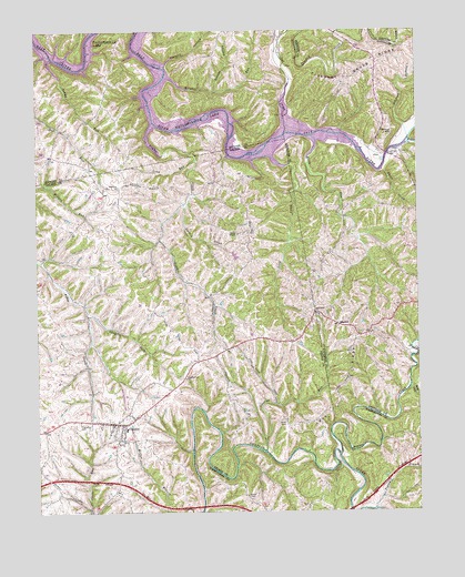
Chaplin, KY USGS Topographic Map
Click on map above to begin viewing in our Map Viewer.

This topographic map contains these locations and features:
Feature Name Type Latitude Longitude GNIS ID View Map
Beaver CreekStreamN37.8901°W85.1505°486611View Map
Buffalo Lick (historical)SpringN37.9679°W85.1338°2555302View Map
Burns CemeteryCemeteryN37.8789°W85.1819°488451View Map
Careys Little Mill Ford (historical)CrossingN37.8906°W85.1530°2567714View Map
ChaplinPopulated PlaceN37.8978°W85.2213°489347View Map
Chaplin Census Designated PlaceCensusN37.8996°W85.2196°2629589View Map
Chaplin ForkStreamN37.9262°W85.2334°489348View Map
Chaplin Fork ChurchChurchN37.9097°W85.2016°489349View Map
Colross Post Office (historical)Post OfficeN37.9679°W85.2449°2567863View Map
Crooked CreekStreamN37.9737°W85.1669°490382View Map
Driscol HillSummitN37.9745°W85.1327°491125View Map
Fairmount ChurchChurchN37.9267°W85.1586°491889View Map
Fairview School (historical)SchoolN37.9804°W85.2428°2567872View Map
Goodnight BridgeBridgeN37.9684°W85.1336°492983View Map
Gordons Ford (historical)CrossingN37.8755°W85.1394°2567727View Map
Green ChapelChurchN37.9472°W85.1836°493265View Map
Heddy RunStreamN37.9937°W85.2450°493996View Map
Highview CemeteryCemeteryN37.8981°W85.2369°494227View Map
Highview ChurchChurchN37.9595°W85.2222°494228View Map
Howster Post Office (historical)Post OfficeN37.9762°W85.2079°2567880View Map
Independence School (historical)SchoolN37.8774°W85.1808°2567731View Map
Johnson BranchStreamN37.9723°W85.1275°495368View Map
Levy CreekStreamN37.9678°W85.1772°496313View Map
Long RunStreamN37.9665°W85.1961°497141View Map
Love RidgeRidgeN37.9045°W85.1511°497215View Map
Mitchell RunStreamN37.9881°W85.2063°498454View Map
Monfort (historical)Populated PlaceN37.8805°W85.1953°2567749View Map
Pigeon BranchStreamN37.8756°W85.1394°500584View Map
Pleasant Grove RidgeRidgeN37.9887°W85.1413°500834View Map
Poverty HollowValleyN37.9913°W85.2070°501227View Map
Price CemeteryCemeteryN37.8978°W85.1683°501320View Map
Short CreekStreamN37.9640°W85.1358°503445View Map
SparrowPopulated PlaceN37.9240°W85.1508°509103View Map
Sparrow Post Office (historical)Post OfficeN37.9230°W85.1512°2566574View Map
Spencer County Fire Protection District Station 5BuildingN37.9678°W85.2444°2637436View Map
Stevens RunStreamN37.8906°W85.1752°504367View Map
Stoney HollowValleyN37.9843°W85.1909°504493View Map
Sweazy CreekStreamN37.9548°W85.2005°504843View Map
Taylorsville LakeReservoirN37.9831°W85.2175°2571204View Map
Timber CreekStreamN37.9762°W85.2105°505285View Map
Van BurenPopulated PlaceN37.9745°W85.1652°505955View Map
Van Buren Church (historical)ChurchN37.9744°W85.1651°2566506View Map
Van Buren Post Office (historical)Post OfficeN37.9745°W85.1659°2566507View Map
Van Buren School (historical)SchoolN37.9745°W85.1669°2566508View Map
Watts RunStreamN37.9726°W85.1583°506298View Map
Wide LickStreamN37.9073°W85.1277°506712View Map
Willow CreekStreamN37.9704°W85.1282°506865View Map

Note: Coordinates in the location and feature list above are referenced to NAD83 datum.


Copyright (C) 2008-2024 Ryan Niemi / Sunset Dynamics ... All Rights Reserved