TopoQuest Logo
Do you find TopoQuest useful?
Help keep TopoQuest running and adding new maps/features by donating!
Bitcoin:  19c7KJd3qBynnjoSw5npx9KScwjBe4ifkT
Litecoin:  LXs6TkuXGGXo1vDsWCkWVdjQX94eUKd6ui
Home View Maps Find Maps Find Places Resources & Links


Chapin, South Carolina Topographic Map

USGS Map Title: Chapin, SC
USGS Map MRC: 34081B3
DRG (GeoTIFF) Download: o34081b3.tif


Neighboring USGS Topographic Map Quads:


  Pomaria, SC  
34081C4
 

  Jenkinsville, SC  
34081C3
 

  Rion, SC  
34081C2
 

  Little Mountain, SC  
34081B4
 

  Chapin, SC  
34081B3
 

  Richtex, SC  
34081B2
 

  Lake Murray West, SC  
34081A4
 

  Lake Murray East, SC  
34081A3
 

  Irmo, SC  
34081A2


Map MRC Location:

N35°
W82°
N35°
W81°
H8 H7 H6 H5 H4 H3 H2 H1
G8 G7 G6 G5 G4 G3 G2 G1
F8 F7 F6 F5 F4 F3 F2 F1
E8 E7 E6 E5 E4 E3 E2 E1
D8 D7 D6 D5 D4 D3 D2 D1
C8 C7 C6 C5 C4 C3 C2 C1
B8 B7 B6 B5 B4 B3 B2 B1
A8 A7 A6 A5 A4 A3 A2 A1
N34°
W82°
N34°
W81°

Chapin, SC USGS 1:24K Topographic Map Preview:
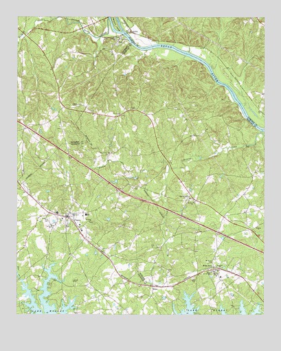
Chapin, SC USGS Topographic Map
Click on map above to begin viewing in our Map Viewer.

This topographic map contains these locations and features:
Feature Name Type Latitude Longitude GNIS ID View Map
AlstonPopulated PlaceN34.2435°W81.3168°1231002View Map
Bear CreekStreamN34.1293°W81.3668°1220401View Map
Bethel CemeteryCemeteryN34.1406°W81.2854°1220540View Map
Bethel ChurchChurchN34.1438°W81.2743°1220564View Map
Bickley CemeteryCemeteryN34.1532°W81.3025°1248944View Map
Boyd Hill School (historical)SchoolN34.1632°W81.2582°1248961View Map
Busbys ShoalsRapidsN34.2371°W81.3134°1236993View Map
Capers ChapelChurchN34.2132°W81.3445°1247158View Map
Capers Chapel CemeteryCemeteryN34.2134°W81.3442°1228392View Map
Chapels ShoalsRapidsN34.2154°W81.2598°1236998View Map
ChapinPopulated PlaceN34.1660°W81.3498°1231155View Map
Chapin DivisionCivilN34.1256°W81.3540°1938222View Map
Chapin Elementary SchoolSchoolN34.1676°W81.3545°1244125View Map
Chapin Park Dam D-1706DamN34.1618°W81.3365°1239237View Map
Chapin Police DepartmentBuildingN34.1679°W81.3548°2734304View Map
Chapman CreekStreamN34.2429°W81.3726°1251627View Map
Columbia - Richland Fire Department Dutch Fork Spring HillBuildingN34.1750°W81.2871°2578605View Map
Crims CreekStreamN34.2496°W81.3287°1229605View Map
David Bounts CemeteryCemeteryN34.2154°W81.3029°1249039View Map
Eargle CemeteryCemeteryN34.1393°W81.3462°1247586View Map
Green Valley EstatesPopulated PlaceN34.1276°W81.3698°1244186View Map
Hancocks Old Ferry (historical)CrossingN34.2196°W81.2670°1237025View Map
Henry Eargle CemeteryCemeteryN34.1516°W81.2850°1249144View Map
Hiller CemeteryCemeteryN34.1254°W81.2968°1249147View Map
HiltonPopulated PlaceN34.1371°W81.3062°1245999View Map
Hopewell CemeteryCemeteryN34.1449°W81.2718°1223280View Map
Hunts BranchStreamN34.2288°W81.2768°1237032View Map
Hunts FordCrossingN34.2324°W81.2826°1237033View Map
Interchange 91CrossingN34.1771°W81.3226°1228195View Map
Jacob Eargle CemeteryCemeteryN34.2006°W81.2864°1249167View Map
Lattakoo (historical)Populated PlaceN34.2096°W81.3540°1228724View Map
Lexington County Fire Service ChapinBuildingN34.1612°W81.3405°2578393View Map
Lowman Home for the AgedBuildingN34.1432°W81.2757°1249208View Map
Meetzer - Orris CemeteryCemeteryN34.2129°W81.2854°1249223View Map
Mile BranchStreamN34.2354°W81.2887°1237043View Map
Mount Hermon Lutheran ChurchChurchN34.2410°W81.3226°1249588View Map
Mount Horeb ChurchChurchN34.1674°W81.3462°1224721View Map
Mount Olivet ChurchChurchN34.1724°W81.2854°1249636View Map
Mount Vernon CemeteryCemeteryN34.1468°W81.2760°1224804View Map
Mount Zion ChurchChurchN34.1626°W81.3576°1224830View Map
Newberry County Rural Fire Department PeakBuildingN34.2416°W81.3234°2578841View Map
PeakPopulated PlaceN34.2407°W81.3234°1250043View Map
Peak CemeteryCemeteryN34.2388°W81.3259°1228787View Map
Peak School (historical)SchoolN34.2335°W81.3284°1228788View Map
Peak School (historical)SchoolN34.2401°W81.3359°1228789View Map
Piney Grove ChurchChurchN34.2093°W81.3229°1225495View Map
Piney Grove School (historical)SchoolN34.2090°W81.3234°1249283View Map
Risters CreekStreamN34.1863°W81.2979°1225890View Map
Rocky CreekStreamN34.2490°W81.3573°1250437View Map
Saint Jacobs Evangelical Lutheran ChurchChurchN34.1782°W81.3140°1250515View Map
Saint Johns ChurchChurchN34.1649°W81.3595°1226156View Map
Saint Simons ChurchChurchN34.2407°W81.3251°1226270View Map
Schmitz CemeteryCemeteryN34.2051°W81.2812°1249343View Map
Spring HillPopulated PlaceN34.1757°W81.2873°1251002View Map
Spring Hill School (historical)SchoolN34.1660°W81.2701°1249366View Map
Stonewall ChurchChurchN34.1640°W81.3382°1226903View Map
Stuck CemeteryCemeteryN34.2113°W81.3151°1251062View Map
SummervillePopulated PlaceN34.2090°W81.3095°1249374View Map
Summerville School (historical)SchoolN34.2099°W81.3104°1249375View Map
Thomas Boyd CemeteryCemeteryN34.2119°W81.2939°1249389View Map
Threewits CemeteryCemeteryN34.1538°W81.3068°1249393View Map
Town of ChapinCivilN34.1646°W81.3449°2406256View Map
Town of PeakCivilN34.2364°W81.3295°2407086View Map
WallacevillePopulated PlaceN34.2121°W81.2526°1237100View Map
White RockPopulated PlaceN34.1451°W81.2757°1231919View Map
White Rock Post OfficePost OfficeN34.1428°W81.2681°1249419View Map
Whites CemeteryCemeteryN34.1876°W81.2526°1249420View Map

Note: Coordinates in the location and feature list above are referenced to NAD83 datum.


Copyright (C) 2008-2024 Ryan Niemi / Sunset Dynamics ... All Rights Reserved