TopoQuest Logo
Do you find TopoQuest useful?
Help keep TopoQuest running and adding new maps/features by donating!
Bitcoin:  19c7KJd3qBynnjoSw5npx9KScwjBe4ifkT
Litecoin:  LXs6TkuXGGXo1vDsWCkWVdjQX94eUKd6ui
Home View Maps Find Maps Find Places Resources & Links


Centre Hall, Pennsylvania Topographic Map

USGS Map Title: Centre Hall, PA
USGS Map MRC: 40077G6
DRG (GeoTIFF) Download: o40077g6.tif


Neighboring USGS Topographic Map Quads:


  Bellefonte, PA  
40077H7
 

  Mingoville, PA  
40077H6
 

  Madisonburg, PA  
40077H5
 

  State College, PA  
40077G7
 

  Centre Hall, PA  
40077G6
 

  Spring Mills, PA  
40077G5
 

  McAlevys Fort, PA  
40077F7
 

  Barrville, PA  
40077F6
 

  Burnham, PA  
40077F5


Map MRC Location:

N41°
W78°
N41°
W77°
H8 H7 H6 H5 H4 H3 H2 H1
G8 G7 G6 G5 G4 G3 G2 G1
F8 F7 F6 F5 F4 F3 F2 F1
E8 E7 E6 E5 E4 E3 E2 E1
D8 D7 D6 D5 D4 D3 D2 D1
C8 C7 C6 C5 C4 C3 C2 C1
B8 B7 B6 B5 B4 B3 B2 B1
A8 A7 A6 A5 A4 A3 A2 A1
N40°
W78°
N40°
W77°

Centre Hall, PA USGS 1:24K Topographic Map Preview:
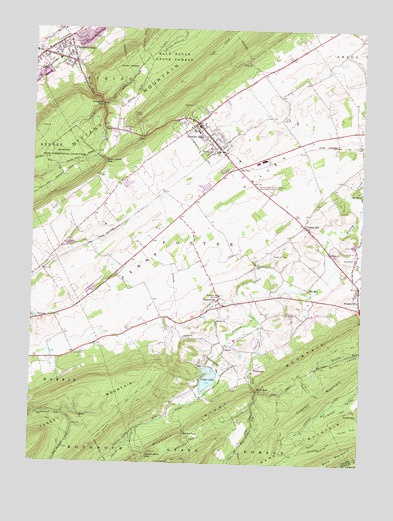
Centre Hall, PA USGS Topographic Map
Click on map above to begin viewing in our Map Viewer.

This topographic map contains these locations and features:
Feature Name Type Latitude Longitude GNIS ID View Map
Bald MountainSummitN40.7526°W77.6339°1168647View Map
Bechtol GapGapN40.7592°W77.6908°1198394View Map
Bethany ChurchChurchN40.7912°W77.6794°1169346View Map
Black Hawk GapGapN40.8370°W77.7225°1169707View Map
Black Hawk Gap RunStreamN40.8222°W77.7100°2084381View Map
Black Hawk QuarryMineN40.8136°W77.7350°2649857View Map
Boal GapGapN40.7717°W77.6633°1169912View Map
Boal Gap RunStreamN40.7926°W77.6650°1169913View Map
Borough of Centre HallCivilN40.8448°W77.6850°1215055View Map
Centre AirparkAirportN40.8118°W77.6567°1194108View Map
Centre HallPopulated PlaceN40.8476°W77.6861°1171514View Map
Centre Hall Fire Company 4BuildingN40.8466°W77.6863°2645666View Map
Centre Hall Post OfficePost OfficeN40.8486°W77.6864°2772629View Map
Centre HillPopulated PlaceN40.8187°W77.6467°1171515View Map
ColyerPopulated PlaceN40.7842°W77.6758°1203313View Map
Colyer LakeReservoirN40.7746°W77.6823°1172256View Map
Colyer Lake DamDamN40.7801°W77.6797°1195038View Map
Deaf Run TrailTrailN40.7645°W77.6544°1173029View Map
Earlytown SchoolSchoolN40.8270°W77.6856°1196793View Map
Emanuels ChurchChurchN40.7987°W77.6778°1174208View Map
Faust FlatFlatN40.7598°W77.6328°1174639View Map
First MountainSummitN40.7840°W77.6400°1174788View Map
FruittownPopulated PlaceN40.7776°W77.6650°1175306View Map
Gap RunStreamN40.8703°W77.7331°1175423View Map
Garbrick Airport (historical)AirportN40.8190°W77.7233°1194112View Map
Goodhart Ridge FarmLocaleN40.8097°W77.6453°2727843View Map
Gregg School (historical)SchoolN40.8184°W77.7164°1196788View Map
Heckendorn GapGapN40.7528°W77.7058°1176745View Map
Independent ChurchChurchN40.8456°W77.7131°1177729View Map
Little MountainSummitN40.7528°W77.7075°1192812View Map
Meadows Psychiatric CenterHospitalN40.8107°W77.7137°2718071View Map
Nittany HallBuildingN40.8033°W77.6897°2103916View Map
Nittany Mountain OverlookLocaleN40.8442°W77.7086°1207013View Map
Oaks Spring FarmLocaleN40.8656°W77.6308°2727841View Map
Old FortPopulated PlaceN40.8353°W77.6717°1204324View Map
Penns CaveLocaleN40.8417°W77.6256°1196792View Map
Pennsylvania State University Agronomy Research FarmLocaleN40.8301°W77.6642°1168014View Map
Pine Stump SchoolSchoolN40.8037°W77.7169°1196789View Map
Pleasant GapGapN40.8534°W77.7236°1184006View Map
Pleasant GapPopulated PlaceN40.8681°W77.7467°1184007View Map
Pleasant Gap Census Designated PlaceCensusN40.8674°W77.7438°2389684View Map
Plum Grove School (historical)SchoolN40.8581°W77.6525°1196791View Map
Potter BrookStreamN40.8078°W77.7422°2092357View Map
Potter RunStreamN40.8198°W77.6267°1184340View Map
Potters MillsPopulated PlaceN40.7959°W77.6253°1184344View Map
Red MillPopulated PlaceN40.8006°W77.6447°1204472View Map
Smith GapGapN40.7642°W77.6253°1187869View Map
Smith TrailTrailN40.7662°W77.6286°1193383View Map
Sprucetown ChurchChurchN40.8090°W77.6272°1188361View Map
Stavefield TrailTrailN40.7706°W77.6431°1188572View Map
Stonefence FarmLocaleN40.7819°W77.6675°2727834View Map
Township of PotterCivilN40.8004°W77.6589°1216135View Map
Triester MountainSummitN40.7665°W77.6439°1189762View Map
Tussey Mountain TrailTrailN40.7631°W77.7147°1193569View Map
Tussey Sink SchoolSchoolN40.7920°W77.6992°1196790View Map
Tusseyridge FarmLocaleN40.7931°W77.6556°2727835View Map
TusseyvillePopulated PlaceN40.7973°W77.6786°1189988View Map
Twin Fir FarmLocaleN40.8417°W77.6489°2727838View Map
Underwood TrailTrailN40.7553°W77.6381°1190085View Map
Willow Run FarmsLocaleN40.8075°W77.6697°2727845View Map

Note: Coordinates in the location and feature list above are referenced to NAD83 datum.


Copyright (C) 2008-2024 Ryan Niemi / Sunset Dynamics ... All Rights Reserved