TopoQuest Logo
Do you find TopoQuest useful?
Help keep TopoQuest running and adding new maps/features by donating!
Bitcoin:  19c7KJd3qBynnjoSw5npx9KScwjBe4ifkT
Litecoin:  LXs6TkuXGGXo1vDsWCkWVdjQX94eUKd6ui
Home View Maps Find Maps Find Places Resources & Links


Centralia, Missouri Topographic Map

USGS Map Title: Centralia, MO
USGS Map MRC: 39092B2
DRG (GeoTIFF) Download: o39092b2.tif


Neighboring USGS Topographic Map Quads:


  Clark, MO  
39092C3
 

  Tulip, MO  
39092C2
 

  Rowena, MO  
39092C1
 

  Sturgeon, MO  
39092B3
 

  Centralia, MO  
39092B2
 

  Centralia NE, MO  
39092B1
 

  Browns, MO  
39092A3
 

  Hallsville, MO  
39092A2
 

  Hatton, MO  
39092A1


Map MRC Location:

N40°
W93°
N40°
W92°
H8 H7 H6 H5 H4 H3 H2 H1
G8 G7 G6 G5 G4 G3 G2 G1
F8 F7 F6 F5 F4 F3 F2 F1
E8 E7 E6 E5 E4 E3 E2 E1
D8 D7 D6 D5 D4 D3 D2 D1
C8 C7 C6 C5 C4 C3 C2 C1
B8 B7 B6 B5 B4 B3 B2 B1
A8 A7 A6 A5 A4 A3 A2 A1
N39°
W93°
N39°
W92°

Centralia, MO USGS 1:24K Topographic Map Preview:
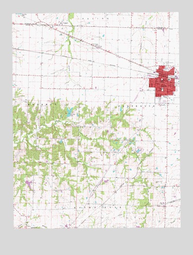
Centralia, MO USGS Topographic Map
Click on map above to begin viewing in our Map Viewer.

This topographic map contains these locations and features:
Feature Name Type Latitude Longitude GNIS ID View Map
A B Chance Company HeliportAirportN39.2153°W92.1271°758634View Map
Angell School (historical)SchoolN39.2120°W92.1727°759328View Map
Boone County Fire Protection District Station 10BuildingN39.2133°W92.1513°2621399View Map
Bunns Lake East DamDamN39.1317°W92.1468°762135View Map
Bunns Lake West DamDamN39.1255°W92.1563°762136View Map
BushLocaleN39.1459°W92.1743°740605View Map
Bush School (historical)SchoolN39.1391°W92.1935°759329View Map
CentraliaPopulated PlaceN39.2103°W92.1380°715695View Map
Centralia CemeteryCemeteryN39.2175°W92.1340°2681353View Map
Centralia Fire Department Station 1BuildingN39.2159°W92.1368°2621221View Map
Centralia Fire Department Station 2BuildingN39.2106°W92.1400°2620575View Map
Centralia High SchoolSchoolN39.2007°W92.1354°2571016View Map
Centralia Intermediate SchoolSchoolN39.2033°W92.1450°2571014View Map
Centralia Police DepartmentBuildingN39.2106°W92.1374°2752399View Map
Centralia Post OfficePost OfficeN39.2103°W92.1383°2783046View Map
Chance Airport (historical)AirportN39.1428°W92.1316°758633View Map
Chance Elementary SchoolSchoolN39.2056°W92.1382°715716View Map
Chester Boren Middle SchoolSchoolN39.2111°W92.1331°2571015View Map
City of CentraliaCivilN39.2106°W92.1344°2393789View Map
Dinwiddie School (historical)SchoolN39.2217°W92.2296°759330View Map
Dunbar School (historical)SchoolN39.1287°W92.1374°759331View Map
Far West CemeteryCemeteryN39.1986°W92.2391°717842View Map
Far West School (historical)SchoolN39.1987°W92.2307°759332View Map
Forrest Lake DamDamN39.1934°W92.1685°762133View Map
Fountain CemeteryCemeteryN39.1964°W92.2121°718122View Map
Fountain Lake DamDamN39.1967°W92.2318°762137View Map
Glendale Memorial GardensCemeteryN39.2201°W92.1344°718504View Map
Good Shepherd ChurchChurchN39.1967°W92.1399°718560View Map
Grassland School (historical)SchoolN39.1667°W92.1349°759333View Map
KMFC-FM (Centralia)TowerN39.1662°W92.1646°759043View Map
LarrabeePopulated PlaceN39.2445°W92.2335°754344View Map
Little CreekStreamN39.1850°W92.2193°721199View Map
Little DixieAreaN39.1334°W92.1335°760187View Map
Lower Lake Chapparel DamDamN39.1567°W92.2418°762134View Map
Montgomery Lake DamDamN39.1757°W92.2136°761375View Map
Musgraves Lake DamDamN39.1517°W92.1818°762031View Map
Pleasant Grove CemeteryCemeteryN39.1516°W92.1438°724480View Map
Roberts Lake DamDamN39.1934°W92.2318°762138View Map
Roberts School (historical)SchoolN39.1284°W92.2403°759334View Map
Roddy Lake DamDamN39.1690°W92.1575°762771View Map
Schnarre LakeReservoirN39.1900°W92.2268°762131View Map
Schnarre Lake Section 23 DamDamN39.1900°W92.2268°762130View Map
Schnarre Section 24 DamDamN39.1967°W92.2185°762132View Map
Sunnydale AcademySchoolN39.2448°W92.2138°727306View Map
Township of CentraliaCivilN39.1973°W92.1531°766331View Map
Tri-City Community Lake DamDamN39.1900°W92.2085°760355View Map
Tri-City LakeReservoirN39.1925°W92.2079°758356View Map
Union CemeteryCemeteryN39.1753°W92.1638°727964View Map
Union School (historical)SchoolN39.1764°W92.1652°759335View Map
Upper Lake ChapperalReservoirN39.1512°W92.2386°761549View Map
Upper Lake Chapperal DamDamN39.1517°W92.2418°761548View Map
Wallace School (historical)SchoolN39.1701°W92.2278°759336View Map

Note: Coordinates in the location and feature list above are referenced to NAD83 datum.


Copyright (C) 2008-2024 Ryan Niemi / Sunset Dynamics ... All Rights Reserved