TopoQuest Logo
Do you find TopoQuest useful?
Help keep TopoQuest running and adding new maps/features by donating!
Bitcoin:  19c7KJd3qBynnjoSw5npx9KScwjBe4ifkT
Litecoin:  LXs6TkuXGGXo1vDsWCkWVdjQX94eUKd6ui
Home View Maps Find Maps Find Places Resources & Links


Center Point NE, Arkansas Topographic Map

USGS Map Title: Center Point NE, AR
USGS Map MRC: 34093B7
DRG (GeoTIFF) Download: o34093b7.tif


Neighboring USGS Topographic Map Quads:


  Athens, AR  
34093C8
 

  Langley, AR  
34093C7
 

  Lodi, AR  
34093C6
 

  Newhope, AR  
34093B8
 

  Center Point NE, AR  
34093B7
 

  Narrows Dam, AR  
34093B6
 

  Center Point, AR  
34093A8
 

  Nathan, AR  
34093A7
 

  Murfreesboro, AR  
34093A6


Map MRC Location:

N35°
W94°
N35°
W93°
H8 H7 H6 H5 H4 H3 H2 H1
G8 G7 G6 G5 G4 G3 G2 G1
F8 F7 F6 F5 F4 F3 F2 F1
E8 E7 E6 E5 E4 E3 E2 E1
D8 D7 D6 D5 D4 D3 D2 D1
C8 C7 C6 C5 C4 C3 C2 C1
B8 B7 B6 B5 B4 B3 B2 B1
A8 A7 A6 A5 A4 A3 A2 A1
N34°
W94°
N34°
W93°

Center Point NE, AR USGS 1:24K Topographic Map Preview:
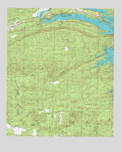
Center Point NE, AR USGS Topographic Map
Click on map above to begin viewing in our Map Viewer.

This topographic map contains these locations and features:
Feature Name Type Latitude Longitude GNIS ID View Map
Arrowhead Point Public Use AreaParkN34.2446°W93.8010°76199View Map
Blue CreekStreamN34.1798°W93.8705°46744View Map
Brickyard CreekStreamN34.2362°W93.8335°46936View Map
Camp TulaLocaleN34.2446°W93.7507°47340View Map
Crawford (historical)Populated PlaceN34.1532°W93.7574°64609View Map
Eden Landmark ChurchChurchN34.2357°W93.8599°48816View Map
Highway 70 Landing Public Use AreaParkN34.2434°W93.8119°77182View Map
Jacobs CreekStreamN34.1357°W93.8410°50574View Map
Lake GreesonReservoirN34.2410°W93.7896°75726View Map
Little CreekStreamN34.1929°W93.7730°51231View Map
Mount Joy ChurchChurchN34.2434°W93.7607°52309View Map
Panther CreekStreamN34.1357°W93.8557°53157View Map
Pine MountainSummitN34.2276°W93.8294°58382View Map
Polk CemeteryCemeteryN34.1473°W93.8641°75269View Map
Polk ChurchChurchN34.1262°W93.8638°78072View Map
Rock CreekStreamN34.2032°W93.7691°54088View Map
Rock Creek Public Use AreaParkN34.2096°W93.7588°78197View Map
Self Creek Public Use AreaParkN34.2371°W93.7630°78311View Map
Shiloh CemeteryCemeteryN34.2382°W93.8446°54775View Map
Star of the West (historical)Populated PlaceN34.2398°W93.8246°64650View Map
Star of the West Public Use AreaParkN34.2390°W93.8252°78446View Map
Township of Muddy ForkCivilN34.1304°W93.8655°66687View Map
Township of WhiteCivilN34.2282°W93.8508°68971View Map
West ForkStreamN34.2390°W93.7585°73332View Map
West Fork Lake GreesonBayN34.2482°W93.7691°56184View Map
White Oak CreekStreamN34.2404°W93.8374°56277View Map
Wildcat BluffCliffN34.1357°W93.8457°56357View Map
Wylie Picnic AreaParkN34.2384°W93.7510°56573View Map

Note: Coordinates in the location and feature list above are referenced to NAD83 datum.


Copyright (C) 2008-2024 Ryan Niemi / Sunset Dynamics ... All Rights Reserved