TopoQuest Logo
Do you find TopoQuest useful?
Help keep TopoQuest running and adding new maps/features by donating!
Bitcoin:  19c7KJd3qBynnjoSw5npx9KScwjBe4ifkT
Litecoin:  LXs6TkuXGGXo1vDsWCkWVdjQX94eUKd6ui
Home View Maps Find Maps Find Places Resources & Links


Hee Creek, Oklahoma Topographic Map

USGS Map Title: Hee Creek, OK
USGS Map MRC: 34094C6
DRG (GeoTIFF) Download: o34094c6.tif


Neighboring USGS Topographic Map Quads:


  White Rock Mountain, OK  
34094D7
 

  Smithville, OK  
34094D6
 

  Watson, OK  
34094D5
 

  Bethel, OK  
34094C7
 

  Hee Creek, OK  
34094C6
 

  Big Hudson Creek, OK  
34094C5
 

  Old Glory Mountain, OK  
34094B7
 

  Stephens Gap, OK  
34094B6
 

  Tablerville, OK  
34094B5


Map MRC Location:

N35°
W95°
N35°
W94°
H8 H7 H6 H5 H4 H3 H2 H1
G8 G7 G6 G5 G4 G3 G2 G1
F8 F7 F6 F5 F4 F3 F2 F1
E8 E7 E6 E5 E4 E3 E2 E1
D8 D7 D6 D5 D4 D3 D2 D1
C8 C7 C6 C5 C4 C3 C2 C1
B8 B7 B6 B5 B4 B3 B2 B1
A8 A7 A6 A5 A4 A3 A2 A1
N34°
W95°
N34°
W94°

Hee Creek, OK USGS 1:24K Topographic Map Preview:
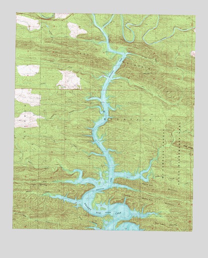
Hee Creek, OK USGS Topographic Map
Click on map above to begin viewing in our Map Viewer.

This topographic map contains these locations and features:
Feature Name Type Latitude Longitude GNIS ID View Map
Bear CreekStreamN34.2662°W94.7022°1089903View Map
Buck CreekStreamN34.3379°W94.6852°1090604View Map
Buffalo CreekStreamN34.3665°W94.6902°1090640View Map
Bull Creek MountainSummitN34.2540°W94.6530°1090680View Map
Cane CreekStreamN34.2762°W94.6813°1090903View Map
Gar CreekStreamN34.2932°W94.6869°1093102View Map
Hee CreekStreamN34.3373°W94.6830°1093644View Map
Hee MountainSummitN34.3484°W94.7011°1093645View Map
Holly CreekStreamN34.2726°W94.6924°1093854View Map
Holly MountainSummitN34.2740°W94.7302°1093857View Map
Hudson CreekStreamN34.3515°W94.6744°1093995View Map
Linson CreekStreamN34.2837°W94.6808°1094698View Map
Little White Oak MountainSummitN34.2659°W94.6352°1094864View Map
McCurtain County Game ReserveParkN34.2971°W94.6333°1095226View Map
McCurtain County Wilderness AreaReserveN34.2959°W94.6411°1738113View Map
North Holly CreekStreamN34.2834°W94.7091°1095969View Map
North Linson CreekStreamN34.2826°W94.6622°1095975View Map
North McCurtain DivisionCivilN34.3495°W94.7353°1937798View Map
Panther BranchStreamN34.3193°W94.6880°1096397View Map
Panther CreekStreamN34.3593°W94.6872°1096408View Map
South Holly CreekStreamN34.2773°W94.7138°1098254View Map
South Linson CreekStreamN34.2826°W94.6613°1098262View Map
Turkey CreekStreamN34.3254°W94.6905°1099026View Map

Note: Coordinates in the location and feature list above are referenced to NAD83 datum.


Copyright (C) 2008-2024 Ryan Niemi / Sunset Dynamics ... All Rights Reserved