TopoQuest Logo
Do you find TopoQuest useful?
Help keep TopoQuest running and adding new maps/features by donating!
Bitcoin:  19c7KJd3qBynnjoSw5npx9KScwjBe4ifkT
Litecoin:  LXs6TkuXGGXo1vDsWCkWVdjQX94eUKd6ui
Home View Maps Find Maps Find Places Resources & Links


Castle Rock, Minnesota Topographic Map

USGS Map Title: Castle Rock, MN
USGS Map MRC: 44093E2
DRG (GeoTIFF) Download: o44093e2.tif


Neighboring USGS Topographic Map Quads:


  Orchard Lake, MN  
44093F3
 

  Farmington, MN  
44093F2
 

  Coates, MN  
44093F1
 

  New Market, MN  
44093E3
 

  Castle Rock, MN  
44093E2
 

  Randolph, MN  
44093E1
 

  Little Chicago, MN  
44093D3
 

  Northfield, MN  
44093D2
 

  Dennison, MN  
44093D1


Map MRC Location:

N45°
W94°
N45°
W93°
H8 H7 H6 H5 H4 H3 H2 H1
G8 G7 G6 G5 G4 G3 G2 G1
F8 F7 F6 F5 F4 F3 F2 F1
E8 E7 E6 E5 E4 E3 E2 E1
D8 D7 D6 D5 D4 D3 D2 D1
C8 C7 C6 C5 C4 C3 C2 C1
B8 B7 B6 B5 B4 B3 B2 B1
A8 A7 A6 A5 A4 A3 A2 A1
N44°
W94°
N44°
W93°

Castle Rock, MN USGS 1:24K Topographic Map Preview:
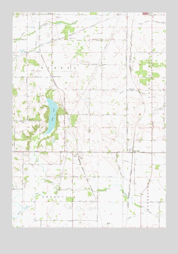
Castle Rock, MN USGS Topographic Map
Click on map above to begin viewing in our Map Viewer.

This topographic map contains these locations and features:
Feature Name Type Latitude Longitude GNIS ID View Map
Applewood OrchardLocaleN44.6194°W93.2256°2663720View Map
Castle RockPopulated PlaceN44.5439°W93.1524°640969View Map
Castle Rock Methodist ChurchChurchN44.5450°W93.1542°2095805View Map
Christiana Post Office (historical)Post OfficeN44.5639°W93.2333°2094737View Map
Chub LakeLakeN44.5651°W93.2178°641208View Map
Curry Airport (historical)AirportN44.6147°W93.2449°660245View Map
Dutch CreekStreamN44.5219°W93.2111°642994View Map
East Christiania CemeteryCemeteryN44.5613°W93.2399°643065View Map
Eureka CenterPopulated PlaceN44.5872°W93.2180°643428View Map
Eureka Center Church (historical)ChurchN44.6236°W93.2304°2487165View Map
Farmington Lutheran CemeteryCemeteryN44.5949°W93.1870°650638View Map
Greenvale CemeteryCemeteryN44.5434°W93.1659°644451View Map
Greenwood CemeteryCemeteryN44.6237°W93.2307°644459View Map
Highview Christiana CemeteryCemeteryN44.5624°W93.2372°2094715View Map
Highview ChurchChurchN44.5627°W93.2377°644960View Map
Jennrich FieldAirportN44.5700°W93.1271°660155View Map
Le Nores Airport (historical)AirportN44.5852°W93.1849°660157View Map
Mud CreekStreamN44.5105°W93.1430°648203View Map
Nielsen's AirportAirportN44.6005°W93.1283°660159View Map
Prairie Creek Community SchoolSchoolN44.5485°W93.1576°2433222View Map
Solar Lutheran CemeteryCemeteryN44.5233°W93.2411°2094714View Map
Township of EurekaCivilN44.5871°W93.2177°664113View Map
Township of GreenvaleCivilN44.5092°W93.2220°664346View Map
Township of WaterfordCivilN44.5077°W93.1300°665929View Map

Note: Coordinates in the location and feature list above are referenced to NAD83 datum.


Copyright (C) 2008-2024 Ryan Niemi / Sunset Dynamics ... All Rights Reserved