TopoQuest Logo
Do you find TopoQuest useful?
Help keep TopoQuest running and adding new maps/features by donating!
Bitcoin:  19c7KJd3qBynnjoSw5npx9KScwjBe4ifkT
Litecoin:  LXs6TkuXGGXo1vDsWCkWVdjQX94eUKd6ui
Home View Maps Find Maps Find Places Resources & Links


Carson, Virginia Topographic Map

USGS Map Title: Carson, VA
USGS Map MRC: 37077A4
DRG (GeoTIFF) Download: o37077a4.tif


Neighboring USGS Topographic Map Quads:


  Sutherland, VA  
37077B5
 

  Petersburg, VA  
37077B4
 

  Prince George, VA  
37077B3
 

  Dinwiddie, VA  
37077A5
 

  Carson, VA  
37077A4
 

  Templeton, VA  
37077A3
 

  Cherry Hill, VA  
36077H5
 

  Stony Creek, VA  
36077H4
 

  Sussex, VA  
36077H3


Map MRC Location:

N38°
W78°
N38°
W77°
H8 H7 H6 H5 H4 H3 H2 H1
G8 G7 G6 G5 G4 G3 G2 G1
F8 F7 F6 F5 F4 F3 F2 F1
E8 E7 E6 E5 E4 E3 E2 E1
D8 D7 D6 D5 D4 D3 D2 D1
C8 C7 C6 C5 C4 C3 C2 C1
B8 B7 B6 B5 B4 B3 B2 B1
A8 A7 A6 A5 A4 A3 A2 A1
N37°
W78°
N37°
W77°

Carson, VA USGS 1:24K Topographic Map Preview:
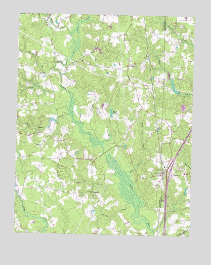
Carson, VA USGS Topographic Map
Click on map above to begin viewing in our Map Viewer.

This topographic map contains these locations and features:
Feature Name Type Latitude Longitude GNIS ID View Map
Appomattox Regional Library System Carson Depot LibraryBuildingN37.0353°W77.3944°2519895View Map
Arthur SwampStreamN37.1027°W77.4600°1462563View Map
Bodlies PondReservoirN37.0603°W77.3977°1463626View Map
Brick Kiln BranchStreamN37.0477°W77.4078°1463802View Map
Brownings Store (historical)LocaleN37.0007°W77.4386°1690720View Map
Butterworth DamDamN37.0818°W77.3847°1490700View Map
Butterworth PondReservoirN37.0848°W77.3885°1490701View Map
Cain DamDamN37.0268°W77.3780°1490728View Map
Cains Mill (historical)LocaleN37.0238°W77.3786°1739871View Map
CarsonPopulated PlaceN37.0354°W77.3953°1464465View Map
Carson Elementary SchoolSchoolN37.0390°W77.3938°1739872View Map
Carson Post OfficePost OfficeN37.0362°W77.3953°1690723View Map
Carson United Methodist ChurchChurchN37.0326°W77.3950°1690724View Map
Carson Volunteer Fire Department - Company 3BuildingN37.0388°W77.3934°2086064View Map
Confederate CemeteryCemeteryN37.0238°W77.4444°1465167View Map
Crawfords Mill (historical)LocaleN37.0818°W77.4805°1690733View Map
District 3CivilN37.1224°W77.4397°1927221View Map
Fox BranchStreamN37.0285°W77.4239°1466821View Map
Gravel Run ChurchChurchN37.0907°W77.4797°1467394View Map
Gravelly RunStreamN37.0943°W77.4736°1467399View Map
Harvells BranchStreamN37.0177°W77.4150°1467805View Map
Hatcher RunStreamN37.0946°W77.4736°1467823View Map
Health Meadows BranchStreamN37.0654°W77.4591°1467888View Map
Indian Swamp DamDamN37.0235°W77.3780°1490714View Map
Indian Swamp PondReservoirN37.0259°W77.3784°1490715View Map
Interchange 37CrossingN37.0346°W77.3903°1739897View Map
Laniers MillpondReservoirN37.0815°W77.3850°1739907View Map
Little Cattail CreekStreamN37.0824°W77.4664°1469497View Map
Little Zion CemeteryCemeteryN37.0432°W77.4808°1690780View Map
Little Zion ChurchChurchN37.0429°W77.4808°1469696View Map
Malone Crossing (historical)LocaleN37.0724°W77.4105°1690783View Map
Monkneck BridgeBridgeN37.0904°W77.4691°1690788View Map
Oak Grove ChurchChurchN37.0963°W77.4200°1471714View Map
Perkins Crossing (historical)LocaleN37.0029°W77.4178°1690799View Map
Perkins DamDamN37.0671°W77.4325°1489617View Map
Perkins PondReservoirN37.0695°W77.4326°1472209View Map
ReamsPopulated PlaceN37.1007°W77.4064°1493475View Map
Reams Store (historical)SchoolN37.0838°W77.4158°1690803View Map
Robinsons Store (historical)LocaleN37.0260°W77.4822°1690805View Map
RowantaPopulated PlaceN37.0424°W77.4444°1690810View Map
Rowanta CemeteryCemeteryN37.0499°W77.4822°1690811View Map
Rowanta ChurchChurchN37.0502°W77.4819°1473601View Map
Rowanty Vocational Technical CenterSchoolN37.0356°W77.3796°1739938View Map
Shiloh CemeteryCemeteryN37.0593°W77.3886°1739948View Map
Shiloh ChurchChurchN37.0590°W77.3886°1474505View Map
Shiloh Crossing (historical)CrossingN37.0529°W77.3908°1739949View Map
Tabernacle ChurchChurchN37.0238°W77.4436°1475427View Map
Warren SwampStreamN37.0352°W77.4208°1476346View Map
Watt Crossing (historical)LocaleN37.1238°W77.4194°1690833View Map
Wedgewood FarmsPopulated PlaceN37.1188°W77.3839°1739963View Map
Zion School (historical)SchoolN37.0263°W77.4775°1690841View Map

Note: Coordinates in the location and feature list above are referenced to NAD83 datum.


Copyright (C) 2008-2024 Ryan Niemi / Sunset Dynamics ... All Rights Reserved