TopoQuest Logo
Do you find TopoQuest useful?
Help keep TopoQuest running and adding new maps/features by donating!
Bitcoin:  19c7KJd3qBynnjoSw5npx9KScwjBe4ifkT
Litecoin:  LXs6TkuXGGXo1vDsWCkWVdjQX94eUKd6ui
Home View Maps Find Maps Find Places Resources & Links


Altamont, California Topographic Map

USGS Map Title: Altamont, CA
USGS Map MRC: 37121F6
DRG (GeoTIFF) Download: o37121f6.tif


Neighboring USGS Topographic Map Quads:


  Tassajara, CA  
37121G7
 

  Byron Hot Springs, CA  
37121G6
 

  Clifton Court Forebay, CA  
37121G5
 

  Livermore, CA  
37121F7
 

  Altamont, CA  
37121F6
 

  Midway, CA  
37121F5
 

  La Costa Valley, CA  
37121E7
 

  Mendenhall Springs, CA  
37121E6
 

  Cedar Mountain, CA  
37121E5


Map MRC Location:

N38°
W122°
N38°
W121°
H8 H7 H6 H5 H4 H3 H2 H1
G8 G7 G6 G5 G4 G3 G2 G1
F8 F7 F6 F5 F4 F3 F2 F1
E8 E7 E6 E5 E4 E3 E2 E1
D8 D7 D6 D5 D4 D3 D2 D1
C8 C7 C6 C5 C4 C3 C2 C1
B8 B7 B6 B5 B4 B3 B2 B1
A8 A7 A6 A5 A4 A3 A2 A1
N37°
W122°
N37°
W121°

Altamont, CA USGS 1:24K Topographic Map Preview:
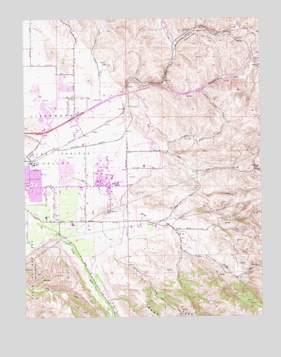
Altamont, CA USGS Topographic Map
Click on map above to begin viewing in our Map Viewer.

This topographic map contains these locations and features:
Feature Name Type Latitude Longitude GNIS ID View Map
Alameda County Fire Department Station 20BuildingN37.6798°W121.7057°2624089View Map
Almond ParkParkN37.6758°W121.7411°1665739View Map
AltamontPopulated PlaceN37.7438°W121.6627°218188View Map
Altamont Creek Elementary SchoolSchoolN37.7228°W121.7183°2518227View Map
Altamont PassGapN37.7458°W121.6583°218189View Map
Andrew N Christensen Middle SchoolSchoolN37.7261°W121.7291°1665740View Map
Arroyo Seco Elementary SchoolSchoolN37.6842°W121.7285°1665741View Map
Big Trees ParkParkN37.6841°W121.7272°1665742View Map
Bill Clark ParkParkN37.7108°W121.7286°1665743View Map
Cedar Mountain WineryLocaleN37.6655°W121.7038°1665746View Map
Christensen ParkParkN37.7241°W121.7288°1665749View Map
Concannon WineryLocaleN37.6669°W121.7400°1665750View Map
Dry CreekStreamN37.6563°W121.7272°1670273View Map
Exit 54CrossingN37.7025°W121.7403°2107576View Map
Exit 55CrossingN37.7092°W121.7236°2107577View Map
Exit 57CrossingN37.7172°W121.7047°2107578View Map
Exit 59CrossingN37.7194°W121.6606°2107579View Map
Frick LakeLakeN37.7307°W121.7108°223949View Map
Green SchoolSchoolN37.7160°W121.7097°224562View Map
Greenville (historical)Populated PlaceN37.7199°W121.6991°1670276View Map
Jackson Avenue Elementary SchoolSchoolN37.6850°W121.7412°226072View Map
Lawrence Livermore National LaboratoryLocaleN37.6858°W121.7055°254901View Map
Leo R Croce Elementary SchoolSchoolN37.7172°W121.7285°1665773View Map
Lincoln Shopping CenterLocaleN37.6808°W121.7477°1665775View Map
Livermore - Pleasanton Fire Department Station 6BuildingN37.6802°W121.7395°1665757View Map
Livermore - Pleasanton Fire Department Station 8BuildingN37.7173°W121.7269°1665759View Map
Livermore Adult Education CenterSchoolN37.6764°W121.7407°218159View Map
Livermore Naval Air Station (historical)MilitaryN37.6853°W121.7064°1723532View Map
Livermore-Pleasanton DivisionCivilN37.6306°W121.7292°1935171View Map
Lone HillSummitN37.6689°W121.7075°2124655View Map
Meadowlark FieldAirportN37.6611°W121.6936°1653612View Map
Muriettas Well WineryLocaleN37.6597°W121.7347°1665790View Map
North Livermore Neighborhood ParkParkN37.7183°W121.7452°1665792View Map
Northfront ParkParkN37.7122°W121.7208°2107603View Map
Patterson 1-062 DamDamN37.6983°W121.6844°1663264View Map
Patterson PassGapN37.6869°W121.6299°230412View Map
Patterson ReservoirReservoirN37.6976°W121.6833°230414View Map
Plaza 580 Shopping CenterLocaleN37.7013°W121.7416°1665796View Map
Robert Livermore ParkParkN37.6819°W121.7377°1665801View Map
Sandia National LaboratoriesLocaleN37.6744°W121.7066°1665804View Map
Springtown Golf CourseLocaleN37.7124°W121.7425°1665806View Map
Stony Ridge WineryLocaleN37.6658°W121.7302°1665807View Map
Summit SchoolSchoolN37.7447°W121.6594°235762View Map
Tex Spruiell ParkParkN37.6905°W121.7263°1665812View Map
Townsend School (historical)SchoolN37.6655°W121.6866°1724022View Map
TrevarnoPopulated PlaceN37.6905°W121.7475°236538View Map
UlmarPopulated PlaceN37.7030°W121.7161°1660071View Map
Vine and Branches Christian SchoolSchoolN37.6794°W121.7405°2518233View Map
Wattenburger ParkParkN37.7088°W121.7438°1665819View Map
Wente Brothers WineryLocaleN37.6641°W121.7258°1665820View Map
William Payne Sports ParkParkN37.6958°W121.7200°2107606View Map

Note: Coordinates in the location and feature list above are referenced to NAD83 datum.


Copyright (C) 2008-2024 Ryan Niemi / Sunset Dynamics ... All Rights Reserved