TopoQuest Logo
Do you find TopoQuest useful?
Help keep TopoQuest running and adding new maps/features by donating!
Bitcoin:  19c7KJd3qBynnjoSw5npx9KScwjBe4ifkT
Litecoin:  LXs6TkuXGGXo1vDsWCkWVdjQX94eUKd6ui
Home View Maps Find Maps Find Places Resources & Links


Toomsuba, Mississippi Topographic Map

USGS Map Title: Toomsuba, MS
USGS Map MRC: 32088D5
DRG (GeoTIFF) Download: o32088d5.tif


Neighboring USGS Topographic Map Quads:


  Daleville, MS  
32088E6
 

  Lauderdale, MS  
32088E5
 

  Tamola, MS  
32088E4
 

  Meridian North, MS  
32088D6
 

  Toomsuba, MS  
32088D5
 

  Kewanee, MS  
32088D4
 

  Meridian South, MS  
32088C6
 

  Vimville, MS  
32088C5
 

  Whynot, MS  
32088C4


Map MRC Location:

N33°
W89°
N33°
W88°
H8 H7 H6 H5 H4 H3 H2 H1
G8 G7 G6 G5 G4 G3 G2 G1
F8 F7 F6 F5 F4 F3 F2 F1
E8 E7 E6 E5 E4 E3 E2 E1
D8 D7 D6 D5 D4 D3 D2 D1
C8 C7 C6 C5 C4 C3 C2 C1
B8 B7 B6 B5 B4 B3 B2 B1
A8 A7 A6 A5 A4 A3 A2 A1
N32°
W89°
N32°
W88°

Toomsuba, MS USGS 1:24K Topographic Map Preview:
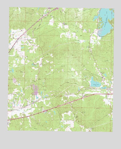
Toomsuba, MS USGS Topographic Map
Click on map above to begin viewing in our Map Viewer.

This topographic map contains these locations and features:
Feature Name Type Latitude Longitude GNIS ID View Map
Academy Hill School (historical)SchoolN32.3951°W88.5423°711345View Map
Bailey LakeReservoirN32.4241°W88.5215°666461View Map
Bill Hobson Pond DamDamN32.3835°W88.5784°681273View Map
Brandon BranchStreamN32.3957°W88.6109°667521View Map
Bright Light ChurchChurchN32.4563°W88.5270°667571View Map
Buster Price Pond DamDamN32.4251°W88.5050°681345View Map
Cagal Lake DamDamN32.4085°W88.5900°681329View Map
Charles Welch Catfish Ponds DamDamN32.4218°W88.5134°681343View Map
Curtis BranchStreamN32.3935°W88.6059°669028View Map
Dalewood Shore LakeReservoirN32.4888°W88.5091°669080View Map
Dalewood Shores Lake DamDamN32.4935°W88.5134°681439View Map
East Jerusalem ChurchChurchN32.4604°W88.5284°669587View Map
Engels Lake DamDamN32.4418°W88.5967°681364View Map
First New Hope ChurchChurchN32.3946°W88.5373°669969View Map
Galilee ChurchChurchN32.4643°W88.5995°670294View Map
Garretts Store (historical)LocaleN32.4771°W88.5339°711385View Map
Good Hope CemeteryCemeteryN32.4274°W88.5895°670465View Map
Good Hope ChurchChurchN32.4254°W88.5931°670476View Map
H L Davis Pond DamDamN32.4585°W88.6084°681392View Map
Hearn CemeteryCemeteryN32.4412°W88.5359°671053View Map
Interchange 160CrossingN32.3954°W88.5800°691509View Map
Interchange 165CrossingN32.4135°W88.5061°691510View Map
John Gilbert Pond DamDamN32.4001°W88.6167°681315View Map
Jones Mill (historical)LocaleN32.4835°W88.5584°711399View Map
Knox Mill (historical)LocaleN32.4357°W88.5598°711402View Map
Lees Mill (historical)LocaleN32.3960°W88.6139°684004View Map
Little Zion ChurchChurchN32.4754°W88.5459°672722View Map
LockhartPopulated PlaceN32.4896°W88.5859°692010View Map
Lockhart CemeteryCemeteryN32.4907°W88.5803°706381View Map
Lockhart ChurchChurchN32.4915°W88.5800°672743View Map
Magnolia White Place (historical)LocaleN32.4501°W88.5703°711408View Map
Melwyn (historical)LocaleN32.3974°W88.6125°711413View Map
Miller CemeteryCemeteryN32.4915°W88.5759°673640View Map
Morgan Lake DamDamN32.4418°W88.5967°681365View Map
Mount Gilead ChurchChurchN32.3782°W88.5253°674003View Map
Mount Zion ChurchChurchN32.4976°W88.5956°674357View Map
Old Marion CemeteryCemeteryN32.4079°W88.6170°675205View Map
Parker CemeteryCemeteryN32.4718°W88.5400°675459View Map
Parker Lakes DamDamN32.3918°W88.5700°681287View Map
Parker Lakes DamDamN32.3951°W88.5700°681298View Map
Pigford CemeteryCemeteryN32.3987°W88.5200°684032View Map
Pleasant Grove ChurchChurchN32.4351°W88.5150°676011View Map
R Rivers Pond DamDamN32.3768°W88.5584°681269View Map
Rawson CemeteryCemeteryN32.3896°W88.5445°676497View Map
Rawsonville (historical)LocaleN32.3793°W88.5514°684037View Map
Richard Randell Pond DamDamN32.4101°W88.6034°681332View Map
RussellPopulated PlaceN32.4038°W88.5939°676963View Map
Russell Baptist ChurchChurchN32.4032°W88.5942°711443View Map
Russell Volunteer Fire and Rescue DepartmentBuildingN32.4041°W88.6004°2668031View Map
Saint Paul ChurchChurchN32.3993°W88.5853°677190View Map
Tom Bailey Lake DamDamN32.4201°W88.5167°681342View Map
ToomsubaPopulated PlaceN32.4185°W88.5070°678818View Map
Toomsuba Baptist ChurchChurchN32.4188°W88.5039°711454View Map
Toomsuba Census Designated PlaceCensusN32.4267°W88.5100°2586611View Map
Toomsuba Post OfficePost OfficeN32.4170°W88.5057°2768639View Map
Toomsuba SchoolSchoolN32.4343°W88.5139°678820View Map
Toomsuba Volunteer Fire DepartmentBuildingN32.4158°W88.5059°2667833View Map
ToptonPopulated PlaceN32.4674°W88.6023°692272View Map
Topton Air Estates AirportAirportN32.4722°W88.6201°680348View Map
W G Williams Pond DamDamN32.4185°W88.5417°681340View Map
Walker ChapelChurchN32.3813°W88.6245°679267View Map
White CemeteryCemeteryN32.4424°W88.5848°679575View Map
Willow Lake DamDamN32.4385°W88.6200°681362View Map

Note: Coordinates in the location and feature list above are referenced to NAD83 datum.


Copyright (C) 2008-2024 Ryan Niemi / Sunset Dynamics ... All Rights Reserved