TopoQuest Logo
Do you find TopoQuest useful?
Help keep TopoQuest running and adding new maps/features by donating!
Bitcoin:  19c7KJd3qBynnjoSw5npx9KScwjBe4ifkT
Litecoin:  LXs6TkuXGGXo1vDsWCkWVdjQX94eUKd6ui
Home View Maps Find Maps Find Places Resources & Links


Cherry Point, North Carolina Topographic Map

USGS Map Title: Cherry Point, NC
USGS Map MRC: 34076H7
DRG (GeoTIFF) Download: o34076h7.tif


Neighboring USGS Topographic Map Quads:


  Upper Broad Creek, NC  
35076A8
 

  Arapahoe, NC  
35076A7
 

  Oriental, NC  
35076A6
 

  Havelock, NC  
34076H8
 

  Cherry Point, NC  
34076H7
 

  Merrimon, NC  
34076H6
 

  Masontown, NC  
34076G8
 

  Newport, NC  
34076G7
 

  Core Creek, NC  
34076G6


Map MRC Location:

N35°
W77°
N35°
W76°
H8 H7 H6 H5 H4 H3 H2 H1
G8 G7 G6 G5 G4 G3 G2 G1
F8 F7 F6 F5 F4 F3 F2 F1
E8 E7 E6 E5 E4 E3 E2 E1
D8 D7 D6 D5 D4 D3 D2 D1
C8 C7 C6 C5 C4 C3 C2 C1
B8 B7 B6 B5 B4 B3 B2 B1
A8 A7 A6 A5 A4 A3 A2 A1
N34°
W77°
N34°
W76°

Cherry Point, NC USGS 1:24K Topographic Map Preview:
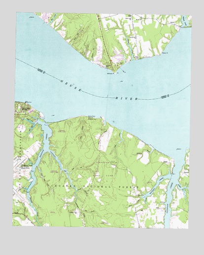
Cherry Point, NC USGS Topographic Map
Click on map above to begin viewing in our Map Viewer.

This topographic map contains these locations and features:
Feature Name Type Latitude Longitude GNIS ID View Map
Alligator GutStreamN34.9721°W76.8194°1008690View Map
BachelorPopulated PlaceN34.9079°W76.7535°1018890View Map
Barney BranchStreamN34.8963°W76.8288°1008940View Map
Big BranchStreamN34.8932°W76.7805°1009256View Map
BladesPopulated PlaceN34.8860°W76.7722°1019211View Map
Cahoogue CreekStreamN34.9199°W76.8505°1009898View Map
Cahoogue Creek SchoolSchoolN34.8838°W76.8288°1009899View Map
Cahooque Creek Recreation SiteParkN34.9168°W76.8499°1008229View Map
Cahooque Creek Recreation SiteLocaleN34.9177°W76.8510°1018089View Map
Camp Don-LeePopulated PlaceN34.9743°W76.7877°1019490View Map
Camp SeagullPopulated PlaceN34.9707°W76.7991°1019499View Map
Cherry BranchStreamN34.9379°W76.8099°1010199View Map
Cherry PointCapeN34.9402°W76.8222°1010219View Map
Cherry Point (historical)Populated PlaceN34.9168°W76.8733°1766220View Map
Cherry Point Landing (historical)LocaleN34.9432°W76.8691°1766222View Map
Cherry Point Landing (historical)Populated PlaceN34.9418°W76.8688°1027391View Map
Club Creek Mobile Home ParkPopulated PlaceN34.8859°W76.7695°2505432View Map
Clubfoot CreekStreamN34.9179°W76.7572°1010341View Map
Dawson CreekStreamN34.9929°W76.7572°1010700View Map
Deep BranchStreamN34.8763°W76.8549°1010721View Map
Dolls GutStreamN34.8968°W76.8641°1010872View Map
Gatlin CreekStreamN34.9729°W76.7916°1011454View Map
Gatlin Creek SchoolSchoolN34.9982°W76.7930°1011455View Map
Gulden CreekStreamN34.9021°W76.7583°1011762View Map
Gum BranchStreamN34.9404°W76.8266°1011766View Map
Hancock CreekStreamN34.9388°W76.8533°1011828View Map
Harlow Volunteer Fire DepartmentBuildingN34.8950°W76.8221°2639065View Map
Jacks BranchStreamN34.9107°W76.8611°1012399View Map
JaneiroPopulated PlaceN34.9957°W76.7652°1020933View Map
King CreekStreamN34.9327°W76.7983°1012629View Map
Little John CreekStreamN34.9102°W76.8574°1012981View Map
Mill CreekStreamN34.9929°W76.8516°1013557View Map
Minnesott BeachPopulated PlaceN34.9688°W76.8116°1021491View Map
Mitchell CreekStreamN34.9054°W76.7624°1013638View Map
Mount Zion ChurchChurchN34.9974°W76.7855°1013778View Map
Pierson PointCapeN34.9777°W76.7713°1014384View Map
Pine Cliff Lookout TowerTowerN34.9135°W76.8055°1023680View Map
Pine Cliff Recreation AreaParkN34.9385°W76.8227°1014414View Map
Piney Grove ChurchChurchN34.8943°W76.7860°1014454View Map
Reeds GutStreamN34.9352°W76.8605°1014806View Map
Sassafras BranchStreamN34.9215°W76.7744°1015261View Map
Shop BranchStreamN34.8910°W76.8636°1015472View Map
Small ChapelChurchN34.9993°W76.7927°1015600View Map
Smith GutStreamN34.9807°W76.8352°1015613View Map
Snake BranchStreamN34.8932°W76.7827°1015623View Map
Spe BranchStreamN34.8840°W76.8249°1015721View Map
Still GutStreamN34.9077°W76.8369°1015836View Map
Still GutStreamN34.9360°W76.8583°995514View Map
TempleLocaleN34.9138°W76.7680°1016066View Map
Town of Minnesott BeachCivilN34.9861°W76.8242°2406169View Map
Township 5CivilN34.9083°W76.7625°1026589View Map
Weeping Mary ChurchChurchN34.9863°W76.7891°1016496View Map
Wilkinson PointCapeN34.9652°W76.8035°1016686View Map

Note: Coordinates in the location and feature list above are referenced to NAD83 datum.


Copyright (C) 2008-2024 Ryan Niemi / Sunset Dynamics ... All Rights Reserved