TopoQuest Logo
Do you find TopoQuest useful?
Help keep TopoQuest running and adding new maps/features by donating!
Bitcoin:  19c7KJd3qBynnjoSw5npx9KScwjBe4ifkT
Litecoin:  LXs6TkuXGGXo1vDsWCkWVdjQX94eUKd6ui
Home View Maps Find Maps Find Places Resources & Links


Moclips, Washington Topographic Map

USGS Map Title: Moclips, WA
USGS Map MRC: 47124B2
DRG (GeoTIFF) Download: o47124b2.tif


Neighboring USGS Topographic Map Quads:


  Taholah, WA  
47124C3
 

  Shale Slough, WA  
47124C2
 

  Macafee Hill, WA  
47124C1


  Moclips, WA  
47124B2
 

  Carlisle, WA  
47124B1


  Copalis Beach, WA  
47124A2
 

  Copalis Crossing, WA  
47124A1


Map MRC Location:

N48°
W125°
N48°
W124°
H8 H7 H6 H5 H4 H3 H2 H1
G8 G7 G6 G5 G4 G3 G2 G1
F8 F7 F6 F5 F4 F3 F2 F1
E8 E7 E6 E5 E4 E3 E2 E1
D8 D7 D6 D5 D4 D3 D2 D1
C8 C7 C6 C5 C4 C3 C2 C1
B8 B7 B6 B5 B4 B3 B2 B1
A8 A7 A6 A5 A4 A3 A2 A1
N47°
W125°
N47°
W124°

Moclips, WA USGS 1:24K Topographic Map Preview:
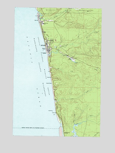
Moclips, WA USGS Topographic Map
Click on map above to begin viewing in our Map Viewer.

This topographic map contains these locations and features:
Feature Name Type Latitude Longitude GNIS ID View Map
AlohaPopulated PlaceN47.2009°W124.1680°1511961View Map
Beaver CreekStreamN47.2065°W124.1880°1503259View Map
Boone CreekStreamN47.1590°W124.1913°1516797View Map
Copalis HeadCliffN47.1470°W124.1880°1504135View Map
Copalis RiverStreamN47.1262°W124.1796°1518062View Map
Copalis RockPillarN47.1490°W124.1943°1504136View Map
Copalis State AirportAirportN47.1460°W124.1894°1533722View Map
Elk CreekStreamN47.1912°W124.1996°1504712View Map
Grays Harbor Fire District 8BuildingN47.2190°W124.2035°2643259View Map
Griffiths-Priday Ocean State ParkParkN47.1304°W124.1774°1513009View Map
Highland HeightsPopulated PlaceN47.2170°W124.2030°1512292View Map
Iron SpringsPopulated PlaceN47.1595°W124.1885°1511054View Map
Joe CreekStreamN47.2068°W124.2030°1521391View Map
MoclipsPopulated PlaceN47.2362°W124.2130°1512471View Map
Moclips Aloha SchoolSchoolN47.2340°W124.2093°1506748View Map
Moclips Census Designated PlaceCensusN47.2349°W124.2027°2408849View Map
Moclips Post OfficePost OfficeN47.2332°W124.2125°2606983View Map
Moclips RiverStreamN47.2479°W124.2193°1523301View Map
Nelson CreekStreamN47.1359°W124.1624°1506953View Map
North Fork Moclips RiverStreamN47.2484°W124.1763°1523807View Map
Ocean GrovePopulated PlaceN47.1820°W124.1963°1511199View Map
Pacific BeachPopulated PlaceN47.2090°W124.2032°1512546View Map
Pacific Beach Census Designated PlaceCensusN47.2150°W124.1965°2585017View Map
Pacific Beach Elementary SchoolSchoolN47.2084°W124.1997°1515111View Map
Pacific Beach Post OfficePost OfficeN47.2097°W124.1991°2769244View Map
Pacific Beach Resort and Conference CenterMilitaryN47.2143°W124.2057°2511970View Map
Pacific Beach Sewage Treatment PlantLocaleN47.2114°W124.1917°2610711View Map
Pacific Beach State ParkParkN47.2054°W124.2027°1510471View Map
Roosevelt BeachLocaleN47.1762°W124.1955°1507906View Map
StearnsvilleLocaleN47.1956°W124.1463°1514718View Map
Sunset BeachPopulated PlaceN47.2259°W124.2091°1512706View Map
Yellow BluffCliffN47.1879°W124.1982°1509655View Map

Note: Coordinates in the location and feature list above are referenced to NAD83 datum.


Copyright (C) 2008-2024 Ryan Niemi / Sunset Dynamics ... All Rights Reserved