TopoQuest Logo
Do you find TopoQuest useful?
Help keep TopoQuest running and adding new maps/features by donating!
Bitcoin:  19c7KJd3qBynnjoSw5npx9KScwjBe4ifkT
Litecoin:  LXs6TkuXGGXo1vDsWCkWVdjQX94eUKd6ui
Home View Maps Find Maps Find Places Resources & Links


Kimberly, Oregon Topographic Map

USGS Map Title: Kimberly, OR
USGS Map MRC: 44119G6
DRG (GeoTIFF) Download: o44119g6.tif


Neighboring USGS Topographic Map Quads:


  Collins Butte, OR  
44119H7
 

  Whitetail Butte, OR  
44119H6
 

  Turner Mountain, OR  
44119H5
 

  Spray, OR  
44119G7
 

  Kimberly, OR  
44119G6
 

  Bologna Basin, OR  
44119G5
 

  Johnson Heights, OR  
44119F7
 

  Mount Misery, OR  
44119F6
 

  Miller Flat, OR  
44119F5


Map MRC Location:

N45°
W120°
N45°
W119°
H8 H7 H6 H5 H4 H3 H2 H1
G8 G7 G6 G5 G4 G3 G2 G1
F8 F7 F6 F5 F4 F3 F2 F1
E8 E7 E6 E5 E4 E3 E2 E1
D8 D7 D6 D5 D4 D3 D2 D1
C8 C7 C6 C5 C4 C3 C2 C1
B8 B7 B6 B5 B4 B3 B2 B1
A8 A7 A6 A5 A4 A3 A2 A1
N44°
W120°
N44°
W119°

Kimberly, OR USGS 1:24K Topographic Map Preview:
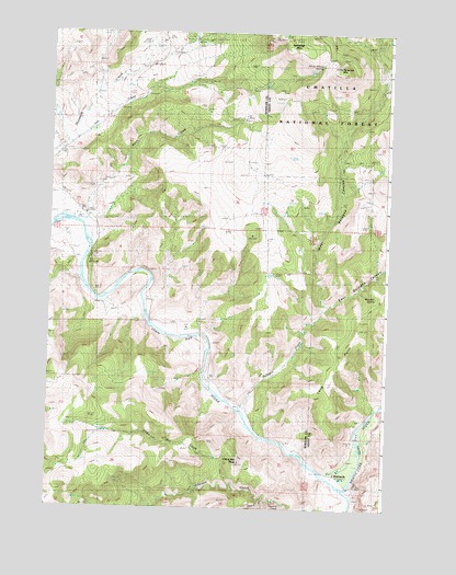
Kimberly, OR USGS Topographic Map
Click on map above to begin viewing in our Map Viewer.

This topographic map contains these locations and features:
Feature Name Type Latitude Longitude GNIS ID View Map
Balm CreekStreamN44.8276°W119.7372°1152933View Map
Bologna CreekStreamN44.7763°W119.6789°1138398View Map
China Hat CreekStreamN44.7563°W119.6819°1139684View Map
China Hat PeakSummitN44.7620°W119.6790°1139685View Map
East Bologna CanyonValleyN44.8032°W119.6475°1141506View Map
Ives CreekStreamN44.8415°W119.7497°1152936View Map
KimberlyPopulated PlaceN44.7593°W119.6444°1144605View Map
Kimberly Post OfficePost OfficeN44.7592°W119.6436°1165482View Map
Knob TrailTrailN44.8393°W119.6436°1156145View Map
Little Tamarack MountainSummitN44.8646°W119.6431°1145278View Map
Long PointRidgeN44.7985°W119.6344°1152930View Map
Mitchell SpringSpringN44.8058°W119.6296°1146375View Map
North Fork John Day RiverStreamN44.7560°W119.6386°1146969View Map
Potter DitchCanalN44.8221°W119.7428°1116527View Map
Second CreekStreamN44.7521°W119.6628°1149206View Map
Spring Valley Post Office (historical)Post OfficeN44.8207°W119.7428°1165976View Map
Tamarack Lookout TowerTowerN44.8738°W119.6615°1156115View Map
Tamarack MountainSummitN44.8740°W119.6625°1150872View Map
Third CreekStreamN44.7526°W119.6694°1128009View Map
West Bologna CanyonValleyN44.8043°W119.6506°1152026View Map
White House SpringSpringN44.8665°W119.6510°1152236View Map

Note: Coordinates in the location and feature list above are referenced to NAD83 datum.


Copyright (C) 2008-2024 Ryan Niemi / Sunset Dynamics ... All Rights Reserved