TopoQuest Logo
Do you find TopoQuest useful?
Help keep TopoQuest running and adding new maps/features by donating!
Bitcoin:  19c7KJd3qBynnjoSw5npx9KScwjBe4ifkT
Litecoin:  LXs6TkuXGGXo1vDsWCkWVdjQX94eUKd6ui
Home View Maps Find Maps Find Places Resources & Links


Williams, Oregon Topographic Map

USGS Map Title: Williams, OR
USGS Map MRC: 42123B3
DRG (GeoTIFF) Download: o42123b3.tif


Neighboring USGS Topographic Map Quads:


  Murphy Mountain, OR  
42123C4
 

  Murphy, OR  
42123C3
 

  Applegate, OR  
42123C2
 

  Kerby Peak, OR  
42123B4
 

  Williams, OR  
42123B3
 

  Tallowbox Mountain, OR  
42123B2
 

  Oregon Caves, OR  
42123A4
 

  Grayback Mountain, OR  
42123A3
 

  Carberry Creek, OR  
42123A2


Map MRC Location:

N43°
W124°
N43°
W123°
H8 H7 H6 H5 H4 H3 H2 H1
G8 G7 G6 G5 G4 G3 G2 G1
F8 F7 F6 F5 F4 F3 F2 F1
E8 E7 E6 E5 E4 E3 E2 E1
D8 D7 D6 D5 D4 D3 D2 D1
C8 C7 C6 C5 C4 C3 C2 C1
B8 B7 B6 B5 B4 B3 B2 B1
A8 A7 A6 A5 A4 A3 A2 A1
N42°
W124°
N42°
W123°

Williams, OR USGS 1:24K Topographic Map Preview:
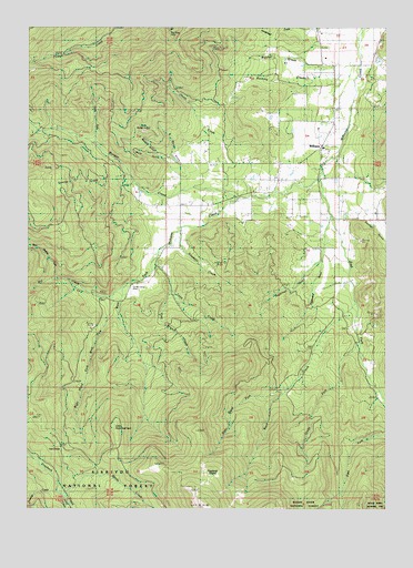
Williams, OR USGS Topographic Map
Click on map above to begin viewing in our Map Viewer.

This topographic map contains these locations and features:
Feature Name Type Latitude Longitude GNIS ID View Map
Baltimore DitchCanalN42.2248°W123.2592°1137493View Map
Bamboo GulchValleyN42.2335°W123.2614°1137494View Map
Banning CreekStreamN42.2396°W123.2606°1137500View Map
Bear MineMineN42.2429°W123.3098°1137727View Map
Bear Wallow CreekStreamN42.1851°W123.3676°1137767View Map
Bill CreekStreamN42.1804°W123.3481°1138108View Map
Blue Jay CreekStreamN42.2346°W123.2637°1155098View Map
Bristol QuarryMineN42.2243°W123.3387°1138634View Map
Brown Owl MineMineN42.2437°W123.3173°1138675View Map
Brown ResReservoirN42.2076°W123.2501°1135053View Map
Browns MillLocaleN42.2035°W123.3342°1138690View Map
Butcher CreekStreamN42.2368°W123.2698°1139035View Map
Caves CampLocaleN42.1790°W123.3378°1139478View Map
Cedar PondReservoirN42.2216°W123.2748°1135381View Map
Cherry GulchValleyN42.2076°W123.2573°1139599View Map
China CreekStreamN42.2148°W123.2892°1139663View Map
Clapboard GulchValleyN42.1915°W123.2734°1139747View Map
Davidson GulchValleyN42.2012°W123.3039°1155094View Map
Dugout SpringSpringN42.2140°W123.2729°1155099View Map
Dunlap ReservoirReservoirN42.2070°W123.3369°1135378View Map
East Fork Williams CreekStreamN42.2112°W123.2748°1141617View Map
Elder GulchValleyN42.1901°W123.3317°1155095View Map
Ferber ReservoirReservoirN42.1960°W123.3227°1135380View Map
Fiddlers GulchValleyN42.1951°W123.2623°1135384View Map
Fourmile CreekStreamN42.1315°W123.3673°1142367View Map
Glade ForkStreamN42.1679°W123.2595°1142761View Map
Goodwin CreekStreamN42.1971°W123.3248°1142848View Map
Gotcher CemeteryCemeteryN42.2446°W123.2764°1142880View Map
Graves ReservoirReservoirN42.2005°W123.3243°1135379View Map
Grayback Clapboard TrailTrailN42.1312°W123.3131°1143007View Map
Grayback GladesFlatN42.1337°W123.3101°1143010View Map
Hartley CemeteryCemeteryN42.2106°W123.2897°1143339View Map
Hartley ReservoirReservoirN42.2109°W123.2977°1155097View Map
Holzhauser ReservoirReservoirN42.2414°W123.2541°1135387View Map
Horsehead CreekStreamN42.2498°W123.2803°1143796View Map
Horsetail CreekStreamN42.1721°W123.2720°1155092View Map
Jenny CreekStreamN42.1273°W123.3628°1144250View Map
Jones Marble QuarryMineN42.2235°W123.3359°1135394View Map
Katzenbach ReservoirReservoirN42.2496°W123.2515°1135383View Map
Kings ReservoirReservoirN42.2289°W123.2718°1135382View Map
Limber Camp (historical)LocaleN42.1290°W123.3734°1154631View Map
Little Sugarloaf PeakSummitN42.1461°W123.3458°1145271View Map
Lone CreekStreamN42.1904°W123.3328°1145349View Map
Low DivideGapN42.1398°W123.3653°1145585View Map
Maple Springs GulchValleyN42.2415°W123.2512°1135386View Map
Miller ReservoirReservoirN42.1996°W123.2773°1135389View Map
Mule GulchValleyN42.2118°W123.3245°1146633View Map
Munger CreekStreamN42.2057°W123.3037°1146661View Map
North Fork Munger CreekStreamN42.2201°W123.3545°1146986View Map
North Marble GulchValleyN42.2112°W123.3209°1147036View Map
Panther GulchValleyN42.2004°W123.2626°1147398View Map
Pipe ForkStreamN42.1437°W123.2512°1147765View Map
Red Rose MineMineN42.2493°W123.3273°1135395View Map
Remey ReservoirReservoirN42.2040°W123.2881°1135388View Map
Right Hand Fork Rock CreekStreamN42.1587°W123.2842°1148445View Map
Right Hand Fork West Fork Williams CreekStreamN42.1829°W123.3431°1148447View Map
Rock CreekStreamN42.1796°W123.2623°1148565View Map
Silver Tip MineMineN42.2373°W123.3662°1149511View Map
South Marble GulchValleyN42.2165°W123.3301°1150055View Map
Sparlin CemeteryCemeteryN42.2446°W123.2728°1135974View Map
Sugarloaf GulchValleyN42.1901°W123.2734°1155091View Map
Sunflower GulchValleyN42.2207°W123.3220°1135391View Map
Swamp CreekStreamN42.2090°W123.3401°1150730View Map
Trader ReservoirReservoirN42.2101°W123.2688°1135390View Map
Tree Branch CreekStreamN42.1804°W123.3259°1158946View Map
Watts MineMineN42.2462°W123.2942°1151972View Map
West Fork Williams CreekStreamN42.2112°W123.2748°1152125View Map
Whittier ReservoirReservoirN42.2009°W123.2657°1159038View Map
Wildcat CreekStreamN42.2068°W123.3345°1155096View Map
WilliamsPopulated PlaceN42.2187°W123.2739°1152385View Map
Williams Census Designated PlaceCensusN42.2194°W123.2922°2611785View Map
Williams DivisionCivilN42.2262°W123.3040°1938155View Map
Williams Forest Service FacilityLocaleN42.2398°W123.2695°1156603View Map
Williams Post OfficePost OfficeN42.2187°W123.2739°1166184View Map
Williams Rural Fire Protection DistrictBuildingN42.2178°W123.2736°2576491View Map
Williamsburg (historical)Populated PlaceN42.2443°W123.2551°1135385View Map
Williamsburg Post Office (historical)Post OfficeN42.2443°W123.2551°1166185View Map
Windy CreekStreamN42.1310°W123.3662°1152506View Map
Yew Wood GulchValleyN42.1998°W123.2831°1155093View Map

Note: Coordinates in the location and feature list above are referenced to NAD83 datum.


Copyright (C) 2008-2024 Ryan Niemi / Sunset Dynamics ... All Rights Reserved