TopoQuest Logo
Do you find TopoQuest useful?
Help keep TopoQuest running and adding new maps/features by donating!
Bitcoin:  19c7KJd3qBynnjoSw5npx9KScwjBe4ifkT
Litecoin:  LXs6TkuXGGXo1vDsWCkWVdjQX94eUKd6ui
Home View Maps Find Maps Find Places Resources & Links


Willard, Ohio Topographic Map

USGS Map Title: Willard, OH
USGS Map MRC: 41082A6
DRG (GeoTIFF) Download: o41082a6.tif


Neighboring USGS Topographic Map Quads:


  Flat Rock, OH  
41082B7
 

  Monroeville, OH  
41082B6
 

  Norwalk, OH  
41082B5
 

  Centerton, OH  
41082A7
 

  Willard, OH  
41082A6
 

  Greenwich, OH  
41082A5
 

  New Washington, OH  
40082H7
 

  Shelby, OH  
40082H6
 

  Shiloh, OH  
40082H5


Map MRC Location:

N42°
W83°
N42°
W82°
H8 H7 H6 H5 H4 H3 H2 H1
G8 G7 G6 G5 G4 G3 G2 G1
F8 F7 F6 F5 F4 F3 F2 F1
E8 E7 E6 E5 E4 E3 E2 E1
D8 D7 D6 D5 D4 D3 D2 D1
C8 C7 C6 C5 C4 C3 C2 C1
B8 B7 B6 B5 B4 B3 B2 B1
A8 A7 A6 A5 A4 A3 A2 A1
N41°
W83°
N41°
W82°

Willard, OH USGS 1:24K Topographic Map Preview:
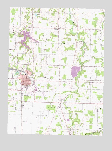
Willard, OH USGS Topographic Map
Click on map above to begin viewing in our Map Viewer.

This topographic map contains these locations and features:
Feature Name Type Latitude Longitude GNIS ID View Map
B & O Railroad Pond 1025-006ReservoirN41.0607°W82.7386°1078004View Map
B & O Railroad Pond 1025-006 DamDamN41.0617°W82.7382°1078003View Map
Bass LakeReservoirN41.0934°W82.7349°1078006View Map
Bass Lake DamDamN41.0934°W82.7349°1078005View Map
Camp CongerLocaleN41.0845°W82.6524°1038679View Map
Camp Conger LakeReservoirN41.0848°W82.6505°1077996View Map
Camp Conger Lake DamDamN41.0851°W82.6516°1077995View Map
CeleryvillePopulated PlaceN41.0298°W82.7318°1038919View Map
Celeryville Census Designated PlaceCensusN41.0287°W82.7273°2628874View Map
Church of God of ProphecyChurchN41.0503°W82.7324°1807541View Map
Church of the NazareneChurchN41.0487°W82.7260°1807542View Map
City of WillardCivilN41.0519°W82.7233°1086362View Map
Coble VillagePopulated PlaceN41.0442°W82.6911°2514850View Map
Egypt School (historical)SchoolN41.0795°W82.7180°1053247View Map
First Presbyterian ChurchChurchN41.0573°W82.7282°1807543View Map
Forest Lake ParkParkN41.1212°W82.6810°1040567View Map
Fullmer Farm CemeteryCemeteryN41.0523°W82.6430°1806294View Map
Grace Methodist ChurchChurchN41.0573°W82.7277°1807544View Map
Graham School (historical)SchoolN41.0778°W82.6421°1053250View Map
Greenwood CemeteryCemeteryN41.0645°W82.7160°1041170View Map
Guinea Corners CemeteryCemeteryN41.0531°W82.6674°1806299View Map
Guinea Corners ChurchChurchN41.0528°W82.6674°1041209View Map
Guinea School (historical)SchoolN41.0531°W82.6674°1053252View Map
Holiday LakeReservoirN41.1017°W82.7316°1078002View Map
Holiday Lake DamDamN41.1017°W82.7316°1078001View Map
Holiday Lakes Census Designated PlaceCensusN41.0924°W82.7291°2628902View Map
Hoyt CemeteryCemeteryN41.1027°W82.6335°1041841View Map
Huron Valley Mobile Home ParkPopulated PlaceN41.0239°W82.6822°2514852View Map
Maple Grove CemeteryCemeteryN41.0225°W82.6796°1042945View Map
Marsh RunStreamN41.0426°W82.6649°1043008View Map
Mary Fate ParkParkN41.0017°W82.6641°1043037View Map
Mennonite CemeteryCemeteryN41.0550°W82.7491°1806305View Map
Mercy Willard HospitalHospitalN41.0394°W82.7095°2548871View Map
New HavenPopulated PlaceN41.0317°W82.6816°1057867View Map
New Haven CemeteryCemeteryN41.0217°W82.6777°1806308View Map
New Haven Census Designated PlaceCensusN41.0306°W82.6814°2628941View Map
New Haven Elementary SchoolSchoolN41.0306°W82.6807°1050249View Map
New Haven Post OfficePost OfficeN41.0320°W82.6818°2011585View Map
Old Greenwood CemeteryCemeteryN41.0628°W82.7171°1806314View Map
Phoenix MillsLocaleN41.0984°W82.6613°1069157View Map
Plymouth Waste Treatment PondReservoirN41.0149°W82.6713°1079375View Map
Plymouth Waste Treatment Pond DamDamN41.0151°W82.6716°1079374View Map
Saint Josephs CemeteryCemeteryN41.0548°W82.7382°1045568View Map
School Number 1 (historical)SchoolN41.0542°W82.7488°1083271View Map
School Number 7 (historical)SchoolN41.1195°W82.6610°1053277View Map
SteubenPopulated PlaceN41.1048°W82.6871°1065382View Map
Steuben CemeteryCemeteryN41.1037°W82.6838°1806326View Map
Steuben Post Office (historical)Post OfficeN41.1042°W82.6874°2011577View Map
Township of GreenfieldCivilN41.1050°W82.6858°1086346View Map
Township of New HavenCivilN41.0297°W82.6781°1086350View Map
Trinity Lutheran ChurchChurchN41.0548°W82.7263°1807545View Map
Walnut CreekStreamN41.0714°W82.6555°1047527View Map
Wheeler School (historical)SchoolN41.1053°W82.7193°1053283View Map
WillardPopulated PlaceN41.0531°W82.7263°1058142View Map
Willard AirportAirportN41.0399°W82.7318°1083116View Map
Willard City ReservoirReservoirN41.0632°W82.6625°1078969View Map
Willard City Upground Reservoir DamDamN41.0567°W82.6649°1078968View Map
Willard Elementary SchoolSchoolN41.0564°W82.7293°1050247View Map
Willard Fire and RescueBuildingN41.0430°W82.7178°2550454View Map
Willard High SchoolSchoolN41.0476°W82.7293°1050248View Map
Willard LakeReservoirN41.1185°W82.7158°1077994View Map
Willard Lake DamDamN41.1184°W82.7166°1077993View Map
Willard Mobile Home ParkPopulated PlaceN41.0408°W82.7039°2514845View Map
Willard Police DepartmentBuildingN41.0504°W82.7257°2732905View Map
Willard Post OfficePost OfficeN41.0559°W82.7260°1082354View Map

Note: Coordinates in the location and feature list above are referenced to NAD83 datum.


Copyright (C) 2008-2024 Ryan Niemi / Sunset Dynamics ... All Rights Reserved