TopoQuest Logo
Do you find TopoQuest useful?
Help keep TopoQuest running and adding new maps/features by donating!
Bitcoin:  19c7KJd3qBynnjoSw5npx9KScwjBe4ifkT
Litecoin:  LXs6TkuXGGXo1vDsWCkWVdjQX94eUKd6ui
Home View Maps Find Maps Find Places Resources & Links


White Pass, Washington Topographic Map

USGS Map Title: White Pass, WA
USGS Map MRC: 46121F4
DRG (GeoTIFF) Download: o46121f4.tif


Neighboring USGS Topographic Map Quads:


  Chinook Pass, WA  
46121G5
 

  Cougar Lake, WA  
46121G4
 

  Bumping Lake, WA  
46121G3
 

  Ohanapecosh Hot Springs, WA  
46121F5
 

  White Pass, WA  
46121F4
 

  Spiral Butte, WA  
46121F3
 

  Packwood Lake, WA  
46121E5
 

  Old Snowy Mountain, WA  
46121E4
 

  Pinegrass Ridge, WA  
46121E3


Map MRC Location:

N47°
W122°
N47°
W121°
H8 H7 H6 H5 H4 H3 H2 H1
G8 G7 G6 G5 G4 G3 G2 G1
F8 F7 F6 F5 F4 F3 F2 F1
E8 E7 E6 E5 E4 E3 E2 E1
D8 D7 D6 D5 D4 D3 D2 D1
C8 C7 C6 C5 C4 C3 C2 C1
B8 B7 B6 B5 B4 B3 B2 B1
A8 A7 A6 A5 A4 A3 A2 A1
N46°
W122°
N46°
W121°

White Pass, WA USGS 1:24K Topographic Map Preview:
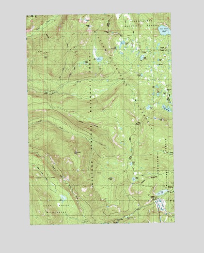
White Pass, WA USGS Topographic Map
Click on map above to begin viewing in our Map Viewer.

This topographic map contains these locations and features:
Feature Name Type Latitude Longitude GNIS ID View Map
Allred CreekStreamN46.7065°W121.4729°1515818View Map
Benchmark LakeLakeN46.7034°W121.3790°1530606View Map
Beusch LakeLakeN46.6937°W121.3969°1534569View Map
Bill LakeLakeN46.7185°W121.3881°1516555View Map
Carlton RidgeRidgeN46.7272°W121.4585°1517406View Map
Chain LakesLakeN46.7209°W121.4517°1517605View Map
Clear Fork TrailTrailN46.6334°W121.4693°1517831View Map
Cortright Creek TrailTrailN46.6876°W121.4462°1518133View Map
Cortright PointCapeN46.6512°W121.4290°1518134View Map
Cowlitz PassGapN46.7007°W121.3809°1518228View Map
Cowlitz TrailTrailN46.7137°W121.4201°1518231View Map
Cowlitz TrailheadLocaleN46.7107°W121.4865°1529606View Map
Cramer MountainSummitN46.6857°W121.3840°1518269View Map
Dark Meadows TrailTrailN46.6546°W121.3904°1518486View Map
Deer LakeLakeN46.6511°W121.4110°1518632View Map
Deerhead LakeLakeN46.7022°W121.3919°1529599View Map
Dumbbell LakeLakeN46.6927°W121.3812°1518999View Map
Fryingpan LakeLakeN46.7317°W121.4189°1519846View Map
Fryingpan MountainSummitN46.7387°W121.4293°1519847View Map
Ginnette LakeLakeN46.6275°W121.3756°1519968View Map
Henry LakeLakeN46.7217°W121.3877°1520724View Map
Jess LakeLakeN46.7057°W121.3894°1521358View Map
Jug LakeLakeN46.7228°W121.4385°1521490View Map
Jug Lake TrailTrailN46.7340°W121.4198°1521492View Map
Kincaid LakeLakeN46.7427°W121.4459°1521672View Map
Kincaid TrailTrailN46.7276°W121.4609°1521673View Map
Knuppenburg LakeLakeN46.6287°W121.4180°1521758View Map
Knuppenburg Lake CampgroundLocaleN46.6284°W121.4193°1529607View Map
Lake TrailTrailN46.7282°W121.4234°1529281View Map
Leech LakeLakeN46.6427°W121.3873°1521990View Map
Lily LakeLakeN46.6406°W121.4721°1522097View Map
Little Snow LakeLakeN46.7292°W121.4237°1522307View Map
Log SpringSpringN46.7255°W121.4859°1522354View Map
Millridge CreekStreamN46.6259°W121.4540°1523195View Map
Penoyer LakeLakeN46.7129°W121.4022°1524326View Map
Pipe LakeLakeN46.7006°W121.3873°1524479View Map
Pony CreekStreamN46.7065°W121.4729°1524568View Map
Sand LakeLakeN46.6601°W121.4125°1525417View Map
Sand Lake ShelterLocaleN46.6593°W121.4131°1530002View Map
Sand Lake TrailTrailN46.6371°W121.4312°1525418View Map
Skeelter ShelterLocaleN46.6298°W121.4693°1525858View Map
Skeeter ShelterLocaleN46.6307°W121.4693°1529421View Map
Snow LakeLakeN46.7233°W121.4020°1526034View Map
Soda Springs CampgroundLocaleN46.7032°W121.4809°1526092View Map
Twin Sisters LakesLakeN46.7382°W121.3793°1527560View Map
White PassGapN46.6387°W121.3895°1528074View Map
White Pass CampgroundLocaleN46.6443°W121.3862°1528076View Map
White Pass Ski AreaLocaleN46.6354°W121.3876°1529424View Map
White Pass X Country Ski AreaLocaleN46.6354°W121.4040°1529423View Map

Note: Coordinates in the location and feature list above are referenced to NAD83 datum.


Copyright (C) 2008-2024 Ryan Niemi / Sunset Dynamics ... All Rights Reserved