TopoQuest Logo
Do you find TopoQuest useful?
Help keep TopoQuest running and adding new maps/features by donating!
Bitcoin:  19c7KJd3qBynnjoSw5npx9KScwjBe4ifkT
Litecoin:  LXs6TkuXGGXo1vDsWCkWVdjQX94eUKd6ui
Home View Maps Find Maps Find Places Resources & Links


Tuleta, Texas Topographic Map

USGS Map Title: Tuleta, TX
USGS Map MRC: 28097E7
DRG (GeoTIFF) Download: o28097e7.tif


Neighboring USGS Topographic Map Quads:


  Monteola, TX  
28097F8
 

  Tulsita, TX  
28097F7
 

  Berclair NW, TX  
28097F6
 

  Mineral, TX  
28097E8
 

  Tuleta, TX  
28097E7
 

  Lazy F Ranch, TX  
28097E6
 

  Cadiz, TX  
28097D8
 

  Beeville West, TX  
28097D7
 

  Beeville East, TX  
28097D6


Map MRC Location:

N29°
W98°
N29°
W97°
H8 H7 H6 H5 H4 H3 H2 H1
G8 G7 G6 G5 G4 G3 G2 G1
F8 F7 F6 F5 F4 F3 F2 F1
E8 E7 E6 E5 E4 E3 E2 E1
D8 D7 D6 D5 D4 D3 D2 D1
C8 C7 C6 C5 C4 C3 C2 C1
B8 B7 B6 B5 B4 B3 B2 B1
A8 A7 A6 A5 A4 A3 A2 A1
N28°
W98°
N28°
W97°

Tuleta, TX USGS 1:24K Topographic Map Preview:
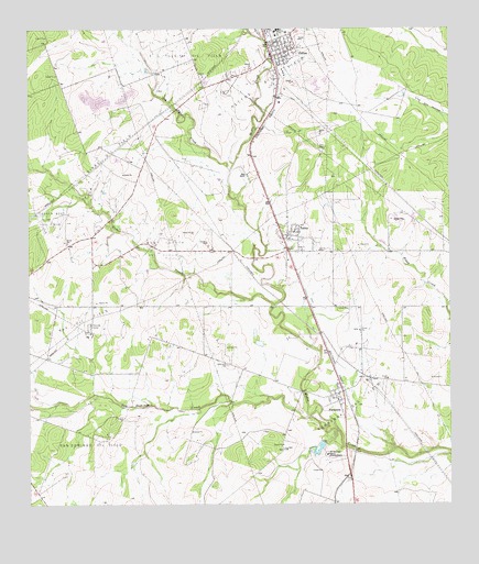
Tuleta, TX USGS Topographic Map
Click on map above to begin viewing in our Map Viewer.

This topographic map contains these locations and features:
Feature Name Type Latitude Longitude GNIS ID View Map
Bee County Constable's Office Precinct 2BuildingN28.5694°W97.7958°2739496View Map
Cosden West Oil FieldOilfieldN28.5719°W97.8692°1355037View Map
Dirks Oil FieldOilfieldN28.5908°W97.8497°1356045View Map
Dougherty ReservoirReservoirN28.5145°W97.7891°1862059View Map
Dougherty Reservoir DamDamN28.5169°W97.7886°1862058View Map
Dry Medio CreekStreamN28.5880°W97.8144°1356368View Map
Hall RanchLocaleN28.5869°W97.8097°1358674View Map
Medio Creek BridgeBridgeN28.5297°W97.7942°2030667View Map
NormannaPopulated PlaceN28.5297°W97.7822°1381021View Map
Normanna CemeteryCemeteryN28.5369°W97.8161°1363971View Map
Normanna Census Designated PlaceCensusN28.5277°W97.7830°2408931View Map
Normanna Gas FieldOilfieldN28.5278°W97.7786°1363972View Map
Normanna Post OfficePost OfficeN28.5285°W97.7845°2731788View Map
PettusPopulated PlaceN28.6180°W97.8022°1365119View Map
Pettus - Tuleta Volunteer Fire Department First RespondersBuildingN28.5707°W97.7982°2334568View Map
Pettus Census Designated PlaceCensusN28.6156°W97.8121°2409059View Map
Pettus Elementary SchoolSchoolN28.6245°W97.7982°2434286View Map
Pettus High SchoolSchoolN28.6248°W97.8011°2434394View Map
Pettus Oil FieldOilfieldN28.6180°W97.7850°1365122View Map
Pettus Post OfficePost OfficeN28.6180°W97.8035°2731797View Map
Ray Oil FieldOilfieldN28.5505°W97.8597°1366069View Map
San Domingo CreekStreamN28.5197°W97.7839°1367490View Map
San Domingo Oil FieldOilfieldN28.5178°W97.8567°1367491View Map
San Domingo RanchLocaleN28.5130°W97.7869°1367492View Map
Toro CreekStreamN28.5525°W97.8019°1370029View Map
TuletaPopulated PlaceN28.5708°W97.7972°1370198View Map
Tuleta Census Designated PlaceCensusN28.5767°W97.7980°2409359View Map
Tuleta Post OfficePost OfficeN28.5711°W97.7990°2732029View Map
Tulsita Oil FieldOilfieldN28.6205°W97.8247°1370202View Map
West Tuleta Oil FieldOilfieldN28.5678°W97.8344°1371246View Map

Note: Coordinates in the location and feature list above are referenced to NAD83 datum.


Copyright (C) 2008-2024 Ryan Niemi / Sunset Dynamics ... All Rights Reserved