TopoQuest Logo
Do you find TopoQuest useful?
Help keep TopoQuest running and adding new maps/features by donating!
Bitcoin:  19c7KJd3qBynnjoSw5npx9KScwjBe4ifkT
Litecoin:  LXs6TkuXGGXo1vDsWCkWVdjQX94eUKd6ui
Home View Maps Find Maps Find Places Resources & Links


Trimble, Alabama Topographic Map

USGS Map Title: Trimble, AL
USGS Map MRC: 34086A8
DRG (GeoTIFF) Download: o34086a8.tif


Neighboring USGS Topographic Map Quads:


  Jones Chapel, AL  
34087B1
 

  West Point, AL  
34086B8
 

  Cullman, AL  
34086B7
 

  Crane Hill, AL  
34087A1
 

  Trimble, AL  
34086A8
 

  Hanceville, AL  
34086A7
 

  Cold Springs, AL  
33087H1
 

  Arkadelphia, AL  
33086H8
 

  Blount Springs, AL  
33086H7


Map MRC Location:

N35°
W87°
N35°
W86°
H8 H7 H6 H5 H4 H3 H2 H1
G8 G7 G6 G5 G4 G3 G2 G1
F8 F7 F6 F5 F4 F3 F2 F1
E8 E7 E6 E5 E4 E3 E2 E1
D8 D7 D6 D5 D4 D3 D2 D1
C8 C7 C6 C5 C4 C3 C2 C1
B8 B7 B6 B5 B4 B3 B2 B1
A8 A7 A6 A5 A4 A3 A2 A1
N34°
W87°
N34°
W86°

Trimble, AL USGS 1:24K Topographic Map Preview:
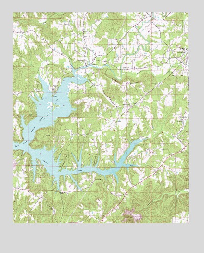
Trimble, AL USGS Topographic Map
Click on map above to begin viewing in our Map Viewer.

This topographic map contains these locations and features:
Feature Name Type Latitude Longitude GNIS ID View Map
Bailey MountainSummitN34.0687°W86.9889°113359View Map
Bavar CreekStreamN34.0879°W86.9236°113578View Map
Beech Grove Baptist ChurchChurchN34.0429°W86.8800°113816View Map
Beech Grove CemeteryCemeteryN34.0426°W86.8803°1805419View Map
Bethlehem CemeteryCemeteryN34.0631°W86.8797°1730297View Map
Bethlehem Methodist ChurchChurchN34.0626°W86.8794°114140View Map
Bowman's Chapel Methodist ChurchChurchN34.0809°W86.9692°114780View Map
Bowmans Chapel CemeteryCemeteryN34.0807°W86.9683°1729935View Map
Brushy CreekStreamN34.0754°W86.9753°115064View Map
Brushy Creek CemeteryCemeteryN34.0573°W86.9797°134871View Map
Brushy Creek Church of Jesus ChristChurchN34.0734°W86.9803°115066View Map
Catalina PointCapeN34.0379°W86.9625°115696View Map
Center Hill Methodist ChurchChurchN34.1223°W86.9067°115874View Map
Clear CreekStreamN34.0937°W86.9464°116231View Map
Clover Valley PondLakeN34.0821°W86.9365°134878View Map
Dodge CityPopulated PlaceN34.0407°W86.8858°1669446View Map
Dodge City Volunteer Fire Department Station 1BuildingN34.0405°W86.8843°2682756View Map
Dodge City Volunteer Fire Department Station 2BuildingN34.0023°W86.8844°2683091View Map
Dogwood PointCapeN34.0382°W86.9417°117353View Map
Foxfire CampgroundLocaleN34.0843°W86.9750°163775View Map
Glory Hill Church of GodChurchN34.0604°W86.8794°119052View Map
Goat IslandIslandN34.0698°W86.9714°119070View Map
Good Hope Fire and Rescue Station 2BuildingN34.0967°W86.8839°2683083View Map
Good Hope High SchoolSchoolN34.1034°W86.8792°134908View Map
Good Hope Missionary Baptist ChurchChurchN34.1029°W86.8764°134909View Map
Hames CampLocaleN34.0359°W86.9144°163774View Map
Hollis PondLakeN34.0067°W86.9435°134914View Map
Hollis Pond DamDamN34.0068°W86.9450°131885View Map
Kinney Grove Missionary Baptist ChurchChurchN34.0237°W86.9700°151961View Map
Kinney MountainSummitN34.0520°W86.9769°121243View Map
Kinneys Grove CemeteryCemeteryN34.0243°W86.9700°1805437View Map
Lone Pine CampLocaleN34.0487°W86.9153°163776View Map
LorettoPopulated PlaceN34.0687°W86.9161°152158View Map
Loretto Volunteer Fire Department and Rapid Responders Station 1BuildingN34.0556°W86.9375°2683023View Map
Loretto Volunteer Fire Department and Rapid Responders Station 2BuildingN34.0673°W86.9179°2683435View Map
Macedonia Freewill Baptist ChurchChurchN34.0698°W86.9167°122173View Map
Misty HarborPopulated PlaceN34.0268°W86.9292°163777View Map
Mountain View Baptist ChurchChurchN34.0915°W86.9203°123534View Map
Reid CreekStreamN34.0351°W86.9222°125556View Map
Rock CreekStreamN34.0907°W86.9569°153175View Map
Sardis Missionary Baptist ChurchChurchN34.1104°W86.9503°153339View Map
Schmmuck MountainRidgeN34.0818°W86.9217°126461View Map
Shady Grove Baptist ChurchChurchN34.0823°W86.8978°113579View Map
Sharon Grove CemeteryCemeteryN34.0965°W86.9494°1805454View Map
Sharon Grove Methodist ChurchChurchN34.0965°W86.9506°153399View Map
Shedd CemeteryCemeteryN34.1033°W86.9510°126659View Map
Simpson CreekStreamN34.0445°W86.9903°126875View Map
Speegle PointCapeN34.0754°W86.9725°127175View Map
Speegles MarinaLocaleN34.0779°W86.9708°163778View Map
Stouts Post Office (historical)Post OfficeN34.0490°W86.8814°166044View Map
Town of Dodge CityCivilN34.0452°W86.8838°2406384View Map
TrimblePopulated PlaceN34.0934°W86.9486°153718View Map
Trimble Volunteer Fire Department Station 1BuildingN34.0954°W86.9489°2683050View Map
Trimble Volunteer Fire Department Station 2BuildingN34.0806°W86.9726°2683064View Map
Valley Grove Church of ChristChurchN34.0654°W86.9156°134974View Map
Valley Springs Baptist ChurchChurchN34.0595°W86.9278°128400View Map
Valley Springs CemeteryCemeteryN34.0590°W86.9272°1730174View Map
Wallace Hathcock DamDamN34.1151°W86.8767°131941View Map

Note: Coordinates in the location and feature list above are referenced to NAD83 datum.


Copyright (C) 2008-2024 Ryan Niemi / Sunset Dynamics ... All Rights Reserved