TopoQuest Logo
Do you find TopoQuest useful?
Help keep TopoQuest running and adding new maps/features by donating!
Bitcoin:  19c7KJd3qBynnjoSw5npx9KScwjBe4ifkT
Litecoin:  LXs6TkuXGGXo1vDsWCkWVdjQX94eUKd6ui
Home View Maps Find Maps Find Places Resources & Links


Sullivan, Illinois Topographic Map

USGS Map Title: Sullivan, IL
USGS Map MRC: 39088E5
DRG (GeoTIFF) Download: o39088e5.tif


Neighboring USGS Topographic Map Quads:


  Lovington, IL  
39088F6
 

  Cadwell, IL  
39088F5
 

  Arthur, IL  
39088F4
 

  Kirksville, IL  
39088E6
 

  Sullivan, IL  
39088E5
 

  Cooks Mills, IL  
39088E4
 

  Middlesworth, IL  
39088D6
 

  Windsor, IL  
39088D5
 

  Mattoon West, IL  
39088D4


Map MRC Location:

N40°
W89°
N40°
W88°
H8 H7 H6 H5 H4 H3 H2 H1
G8 G7 G6 G5 G4 G3 G2 G1
F8 F7 F6 F5 F4 F3 F2 F1
E8 E7 E6 E5 E4 E3 E2 E1
D8 D7 D6 D5 D4 D3 D2 D1
C8 C7 C6 C5 C4 C3 C2 C1
B8 B7 B6 B5 B4 B3 B2 B1
A8 A7 A6 A5 A4 A3 A2 A1
N39°
W89°
N39°
W88°

Sullivan, IL USGS 1:24K Topographic Map Preview:
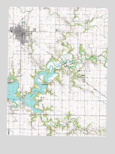
Sullivan, IL USGS Topographic Map
Click on map above to begin viewing in our Map Viewer.

This topographic map contains these locations and features:
Feature Name Type Latitude Longitude GNIS ID View Map
AllenvillePopulated PlaceN39.5556°W88.5298°403437View Map
Asa CreekStreamN39.5634°W88.5759°403647View Map
Baker School (historical)SchoolN39.5217°W88.6212°403836View Map
Bolin BranchStreamN39.6095°W88.5409°404660View Map
Bolin CemeteryCemeteryN39.6117°W88.5264°1721069View Map
Bolin School (historical)SchoolN39.6228°W88.5278°404661View Map
BrucePopulated PlaceN39.5189°W88.5945°404994View Map
Church of ChristChurchN39.5956°W88.6145°1822138View Map
City of SullivanCivilN39.5953°W88.6085°2395997View Map
Coon CreekStreamN39.5675°W88.5414°406526View Map
Crabapple CreekStreamN39.5073°W88.5045°406708View Map
Daugherty CemeteryCemeteryN39.5914°W88.5620°1721072View Map
Elizabeth Titus Memorial LibraryBuildingN39.5978°W88.6078°1822139View Map
First Baptist ChurchChurchN39.5992°W88.6051°1822141View Map
First Christian ChurchChurchN39.6023°W88.5851°1822142View Map
First Church of GodChurchN39.6003°W88.5945°1822143View Map
First Presbyterian ChurchChurchN39.6009°W88.6078°1822144View Map
First United Methodist ChurchChurchN39.5989°W88.6101°1822145View Map
Forrest W Wood Access AreaParkN39.5514°W88.6223°1721075View Map
French CemeteryCemeteryN39.5505°W88.5559°1721076View Map
French Church (historical)ChurchN39.5506°W88.5562°408738View Map
Greenhill CemeteryCemeteryN39.5979°W88.6008°1721077View Map
Hagerman CemeteryCemeteryN39.6234°W88.5784°1721078View Map
Highway Church of ChristChurchN39.6009°W88.6142°1822147View Map
Illinois Masonic HomeBuildingN39.6025°W88.5648°1721092View Map
Illinois Masonic Home CemeteryCemeteryN39.6000°W88.5573°1721091View Map
Illinois Natural History Survey AreaParkN39.5511°W88.5795°1721081View Map
Jean Wood Airport (historical)AirportN39.5242°W88.6126°1721082View Map
Jonathan CreekStreamN39.5720°W88.5531°411199View Map
Jonathan Creek Christian ChurchChurchN39.6111°W88.5289°411200View Map
Jonathon Creek CemeteryCemeteryN39.6111°W88.5287°1934575View Map
Kaskaskia River State Fish and Wildlife Management AreaParkN39.5686°W88.5551°1721085View Map
Lowe SchoolSchoolN39.5975°W88.6106°1721088View Map
Lynn CreekStreamN39.5089°W88.5367°412764View Map
Masonic CemeteryCemeteryN39.6000°W88.5589°1984104View Map
Masonic HomeLocaleN39.6028°W88.5653°1984105View Map
Miller School (historical)SchoolN39.5898°W88.5239°413595View Map
Morgan School (historical)SchoolN39.5573°W88.6095°413822View Map
Moultrie County CourthouseBuildingN39.5989°W88.6070°1721095View Map
Palmyra School (historical)SchoolN39.5356°W88.5667°415324View Map
Powers Elementary SchoolSchoolN39.6014°W88.6101°1721099View Map
Purvis CemeteryCemeteryN39.5720°W88.5567°1721100View Map
Purvis School (historical)SchoolN39.5870°W88.5653°416293View Map
Saint Columcille Catholic ChurchChurchN39.6011°W88.6134°1822149View Map
Smyser ChurchChurchN39.5025°W88.5231°1721101View Map
Smysor School (historical)SchoolN39.5028°W88.5270°418662View Map
Strickland School (historical)SchoolN39.5648°W88.5903°419219View Map
SullivanPopulated PlaceN39.5995°W88.6078°419327View Map
Sullivan City HallBuildingN39.5998°W88.6078°1721102View Map
Sullivan Fire Protection and Ambulance DistrictBuildingN39.5990°W88.6090°2681944View Map
Sullivan High SchoolSchoolN39.6064°W88.6087°1822151View Map
Sullivan Middle SchoolSchoolN39.6059°W88.6087°1822152View Map
Sullivan Police DepartmentBuildingN39.5971°W88.6084°2759050View Map
Sullivan Post OfficePost OfficeN39.5988°W88.6053°1721103View Map
Sullivan Recreation AreaParkN39.5331°W88.6109°1822153View Map
Sword of the Lord Assembly of God ChurchChurchN39.5992°W88.6181°1822154View Map
Titus School (historical)SchoolN39.6245°W88.6037°419750View Map
Township of East NelsonCivilN39.5642°W88.5284°428936View Map
Twomile BranchStreamN39.6073°W88.5456°419992View Map
Vernon School (historical)SchoolN39.5361°W88.5378°420273View Map
Village of AllenvilleCivilN39.5587°W88.5389°2397937View Map
Wagonner Church (historical)ChurchN39.5209°W88.5659°420375View Map
Whitfield CemeteryCemeteryN39.5005°W88.5724°1721109View Map
Whitfield School (historical)SchoolN39.5017°W88.5659°421102View Map
Whitley CreekStreamN39.5300°W88.5981°421106View Map
Wood LakeReservoirN39.5277°W88.6162°1691887View Map
Wood Lake DamDamN39.5267°W88.6117°1691886View Map
Wyman ParkParkN39.6070°W88.6065°1721110View Map

Note: Coordinates in the location and feature list above are referenced to NAD83 datum.


Copyright (C) 2008-2024 Ryan Niemi / Sunset Dynamics ... All Rights Reserved