TopoQuest Logo
Do you find TopoQuest useful?
Help keep TopoQuest running and adding new maps/features by donating!
Bitcoin:  19c7KJd3qBynnjoSw5npx9KScwjBe4ifkT
Litecoin:  LXs6TkuXGGXo1vDsWCkWVdjQX94eUKd6ui
Home View Maps Find Maps Find Places Resources & Links


Spring Hill, Arkansas Topographic Map

USGS Map Title: Spring Hill, AR
USGS Map MRC: 33093E6
DRG (GeoTIFF) Download: o33093e6.tif


Neighboring USGS Topographic Map Quads:


  McNab, AR  
33093F7
 

  Sheppard, AR  
33093F6
 

  Hope, AR  
33093F5
 

  Fulton, AR  
33093E7
 

  Spring Hill, AR  
33093E6
 

  Patmos, AR  
33093E5
 

  Fouke NE, AR  
33093D7
 

  Boyd Hill, AR  
33093D6
 

  Old Town, AR  
33093D5


Map MRC Location:

N34°
W94°
N34°
W93°
H8 H7 H6 H5 H4 H3 H2 H1
G8 G7 G6 G5 G4 G3 G2 G1
F8 F7 F6 F5 F4 F3 F2 F1
E8 E7 E6 E5 E4 E3 E2 E1
D8 D7 D6 D5 D4 D3 D2 D1
C8 C7 C6 C5 C4 C3 C2 C1
B8 B7 B6 B5 B4 B3 B2 B1
A8 A7 A6 A5 A4 A3 A2 A1
N33°
W94°
N33°
W93°

Spring Hill, AR USGS 1:24K Topographic Map Preview:
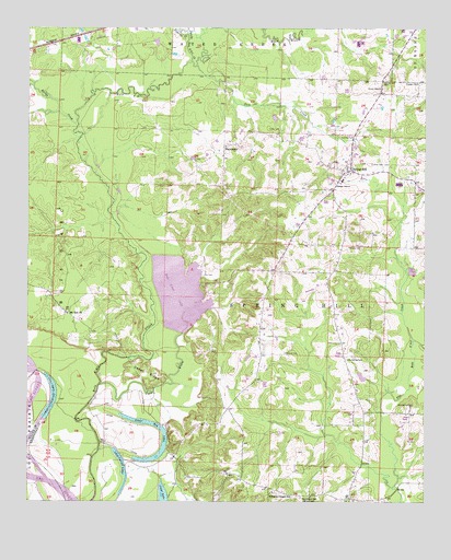
Spring Hill, AR USGS Topographic Map
Click on map above to begin viewing in our Map Viewer.

This topographic map contains these locations and features:
Feature Name Type Latitude Longitude GNIS ID View Map
Andersons School (historical)SchoolN33.5426°W93.6774°61544View Map
BattlefieldPopulated PlaceN33.5935°W93.6885°57341View Map
Bethany CemeteryCemeteryN33.5676°W93.6449°46419View Map
Bethany Church (historical)ChurchN33.5401°W93.6910°61543View Map
Bois D'Arc Creek Wildlife Management AreaParkN33.5737°W93.7196°61542View Map
Bois d'Arc LakeLakeN33.5554°W93.7026°75657View Map
Bridge CreekStreamN33.5990°W93.7349°46941View Map
Cedar BayouStreamN33.5307°W93.7277°47561View Map
Cedar RidgeRidgeN33.5351°W93.7127°47622View Map
Dooleys Ferry (historical)CrossingN33.5018°W93.7385°61467View Map
Forest Grove Church (historical)ChurchN33.5807°W93.6730°61545View Map
Foster CemeteryCemeteryN33.5987°W93.6707°49189View Map
Goss CreekStreamN33.6151°W93.6971°49523View Map
Hervey CemeteryCemeteryN33.6109°W93.6382°50032View Map
Holly Spring CemeteryCemeteryN33.5384°W93.6474°50237View Map
Holly Springs Church (historical)ChurchN33.5387°W93.6471°61546View Map
Lower Red LakeLakeN33.5116°W93.7099°75779View Map
Mount Zion ChurchChurchN33.5496°W93.7377°52456View Map
Nineteen hundred and forty Cut-off LakeLakeN33.5233°W93.7443°75803View Map
Nineteen hundred and sixteen Cut-offLakeN33.5130°W93.7223°75804View Map
Peavine CreekStreamN33.6235°W93.6996°53256View Map
Phillips CemeteryCemeteryN33.5396°W93.6691°53332View Map
Providence CemeteryCemeteryN33.5259°W93.6285°53821View Map
Sandy Bois d'Arc CreekStreamN33.6162°W93.6988°54571View Map
Spring HillPopulated PlaceN33.5876°W93.6485°58671View Map
Spring Hill Elementary SchoolSchoolN33.5849°W93.6512°61548View Map
Spring Hill High SchoolSchoolN33.5858°W93.6503°61547View Map
Springhill Volunteer Fire DepartmentBuildingN33.5889°W93.6498°2117167View Map
Stevenson SchoolLocaleN33.5015°W93.6610°55213View Map
Sullivan CemeteryCemeteryN33.5968°W93.6496°55316View Map
Township of SpringhillCivilN33.5474°W93.6619°66648View Map
Turner CemeteryCemeteryN33.5893°W93.6418°55736View Map
Union ChurchChurchN33.6104°W93.6277°55797View Map
Williams Chapel SchoolSchoolN33.5026°W93.6730°56396View Map

Note: Coordinates in the location and feature list above are referenced to NAD83 datum.


Copyright (C) 2008-2024 Ryan Niemi / Sunset Dynamics ... All Rights Reserved