TopoQuest Logo
Do you find TopoQuest useful?
Help keep TopoQuest running and adding new maps/features by donating!
Bitcoin:  19c7KJd3qBynnjoSw5npx9KScwjBe4ifkT
Litecoin:  LXs6TkuXGGXo1vDsWCkWVdjQX94eUKd6ui
Home View Maps Find Maps Find Places Resources & Links


Sparkman NW, Arkansas Topographic Map

USGS Map Title: Sparkman NW, AR
USGS Map MRC: 33092H8
DRG (GeoTIFF) Download: o33092h8.tif


Neighboring USGS Topographic Map Quads:


  Arkadelphia, AR  
34093A1
 

  Dalark, AR  
34092A8
 

  Manning, AR  
34092A7
 

  Curtis, AR  
33093H1
 

  Sparkman NW, AR  
33092H8
 

  Sparkman, AR  
33092H7
 

  Reader, AR  
33093G1
 

  Tates Bluff, AR  
33092G8
 

  Ouachita, AR  
33092G7


Map MRC Location:

N34°
W93°
N34°
W92°
H8 H7 H6 H5 H4 H3 H2 H1
G8 G7 G6 G5 G4 G3 G2 G1
F8 F7 F6 F5 F4 F3 F2 F1
E8 E7 E6 E5 E4 E3 E2 E1
D8 D7 D6 D5 D4 D3 D2 D1
C8 C7 C6 C5 C4 C3 C2 C1
B8 B7 B6 B5 B4 B3 B2 B1
A8 A7 A6 A5 A4 A3 A2 A1
N33°
W93°
N33°
W92°

Sparkman NW, AR USGS 1:24K Topographic Map Preview:
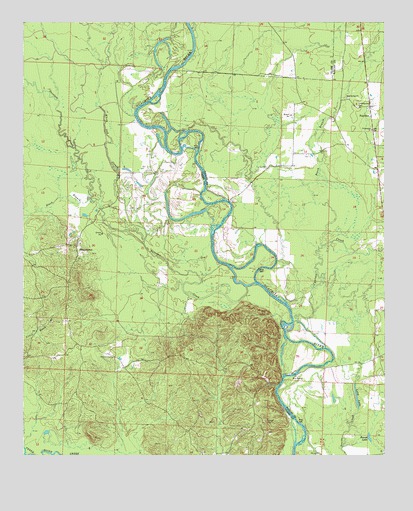
Sparkman NW, AR USGS Topographic Map
Click on map above to begin viewing in our Map Viewer.

This topographic map contains these locations and features:
Feature Name Type Latitude Longitude GNIS ID View Map
Beach BranchStreamN33.9315°W92.9127°76262View Map
Black BranchStreamN33.9484°W92.9757°46661View Map
Casa Massa CreekStreamN33.9984°W92.9413°76542View Map
Centerpoint CemeteryCemeteryN33.9756°W92.8843°47647View Map
Centerpoint ChurchChurchN33.9690°W92.8796°47648View Map
Cypress CreekStreamN33.9137°W92.9068°48305View Map
Deceiper CreekStreamN33.9248°W92.9196°76771View Map
FairviewPopulated PlaceN33.9732°W92.8796°57740View Map
Hebron (historical)Populated PlaceN33.9043°W92.9707°65022View Map
Jackson (historical)Populated PlaceN33.9523°W92.8766°60972View Map
Long LakeLakeN33.8920°W92.8849°75770View Map
Nix FerryLocaleN33.8984°W92.9063°52782View Map
Rock Springs ChurchChurchN33.9782°W92.8879°54113View Map
Round LakeLakeN33.8803°W92.8805°75834View Map
ShakertownPopulated PlaceN33.9343°W92.9818°58599View Map
Township of Anderson (historical)CivilN33.9334°W92.9974°65010View Map
Union Grove ChurchChurchN33.9034°W92.9693°55813View Map
White Oak SloughStreamN33.9359°W92.9582°56299View Map

Note: Coordinates in the location and feature list above are referenced to NAD83 datum.


Copyright (C) 2008-2024 Ryan Niemi / Sunset Dynamics ... All Rights Reserved