TopoQuest Logo
Do you find TopoQuest useful?
Help keep TopoQuest running and adding new maps/features by donating!
Bitcoin:  19c7KJd3qBynnjoSw5npx9KScwjBe4ifkT
Litecoin:  LXs6TkuXGGXo1vDsWCkWVdjQX94eUKd6ui
Home View Maps Find Maps Find Places Resources & Links


Canyon Village, Wyoming Topographic Map

USGS Map Title: Canyon Village, WY
USGS Map MRC: 44110F4
DRG (GeoTIFF) Download: o44110f4.tif


Neighboring USGS Topographic Map Quads:


  Cook Peak, WY  
44110G5
 

  Mount Washburn, WY  
44110G4
 

  Amethyst Mountain, WY  
44110G3
 

  Crystal Falls, WY  
44110F5
 

  Canyon Village, WY  
44110F4
 

  White Lake, WY  
44110F3
 

  Beach Lake, WY  
44110E5
 

  Lake, WY  
44110E4
 

  Lake Butte, WY  
44110E3


Map MRC Location:

N45°
W111°
N45°
W110°
H8 H7 H6 H5 H4 H3 H2 H1
G8 G7 G6 G5 G4 G3 G2 G1
F8 F7 F6 F5 F4 F3 F2 F1
E8 E7 E6 E5 E4 E3 E2 E1
D8 D7 D6 D5 D4 D3 D2 D1
C8 C7 C6 C5 C4 C3 C2 C1
B8 B7 B6 B5 B4 B3 B2 B1
A8 A7 A6 A5 A4 A3 A2 A1
N44°
W111°
N44°
W110°

Canyon Village, WY USGS 1:24K Topographic Map Preview:
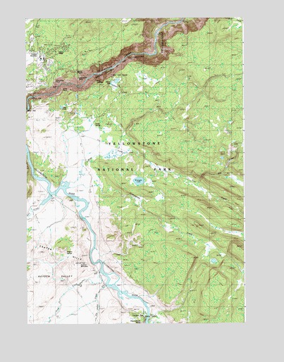
Canyon Village, WY USGS Topographic Map
Click on map above to begin viewing in our Map Viewer.

This topographic map contains these locations and features:
Feature Name Type Latitude Longitude GNIS ID View Map
Alum CreekStreamN44.6741°W110.4921°1584812View Map
Artist PointCapeN44.7210°W110.4794°1584958View Map
Bog CreekStreamN44.6824°W110.4044°1585734View Map
Canyon JunctionPopulated PlaceN44.7360°W110.4933°1597245View Map
Canyon VillagePopulated PlaceN44.7338°W110.4899°1597246View Map
Cascade CreekStreamN44.7166°W110.4994°1586413View Map
Clear LakeLakeN44.7136°W110.4797°1586765View Map
Cottongrass CreekStreamN44.6816°W110.4671°1587008View Map
Crater HillsRangeN44.6569°W110.4735°1587185View Map
Dragons Mouth SpringSpringN44.6252°W110.4350°1609244View Map
Elk Antler CreekStreamN44.6402°W110.4558°1588213View Map
Forest SpringsSpringN44.7085°W110.4616°1588620View Map
Glacial BoulderLocaleN44.7277°W110.4705°1588920View Map
Glacial Boulder TrailTrailN44.7422°W110.4516°1588921View Map
Grand ViewCapeN44.7266°W110.4799°1597162View Map
Hayden ValleyValleyN44.6791°W110.4821°1589419View Map
Inspiration PointCliffN44.7252°W110.4702°1609264View Map
Lookout PointCapeN44.7233°W110.4841°1609350View Map
Lower Falls of the Yellowstone RiverFallsN44.7180°W110.4964°1609116View Map
Mud PotsSpringN44.6277°W110.4358°1605595View Map
Point SublimeCliffN44.7244°W110.4608°1592898View Map
Red RockPillarN44.7208°W110.4924°1609349View Map
Ribbon LakeLakeN44.7236°W110.4511°1608471View Map
Ribbon Lake TrailTrailN44.7172°W110.4708°1593421View Map
Silver Cord CascadeFallsN44.7260°W110.4516°1609299View Map
Sour CreekStreamN44.6841°W110.4705°1594579View Map
Sour Creek TrailTrailN44.7030°W110.4721°1594580View Map
Sulphur CaldronSpringN44.6278°W110.4328°1609305View Map
Sulphur MountainSummitN44.6489°W110.4696°1609306View Map
Sulphur SpringSpringN44.6541°W110.4813°1609351View Map
Surface CreekStreamN44.7294°W110.4516°1595216View Map
Trout CreekStreamN44.6463°W110.4594°1595719View Map
Turbulent PoolSpringN44.6283°W110.4335°1848607View Map
Upper Falls of the Yellowstone RiverFallsN44.7128°W110.4998°1595859View Map
Wrangler LakeLakeN44.6834°W110.4355°1596632View Map
Yellowstone National Park DivisionCivilN44.7381°W110.4139°1939753View Map
Yellowstone National Park Fire Department Canyon StationBuildingN44.7364°W110.4909°2673621View Map

Note: Coordinates in the location and feature list above are referenced to NAD83 datum.


Copyright (C) 2008-2024 Ryan Niemi / Sunset Dynamics ... All Rights Reserved