TopoQuest Logo
Do you find TopoQuest useful?
Help keep TopoQuest running and adding new maps/features by donating!
Bitcoin:  19c7KJd3qBynnjoSw5npx9KScwjBe4ifkT
Litecoin:  LXs6TkuXGGXo1vDsWCkWVdjQX94eUKd6ui
Home View Maps Find Maps Find Places Resources & Links


Richmond, Indiana Topographic Map

USGS Map Title: Richmond, IN
USGS Map MRC: 39084G8
DRG (GeoTIFF) Download: o39084g8.tif


Neighboring USGS Topographic Map Quads:


  Greens Fork, IN  
39085H1
 

  Fountain City, IN  
39084H8
 

  Whitewater, IN  
39084H7
 

  Jacksonburg, IN  
39085G1
 

  Richmond, IN  
39084G8
 

  New Paris, OH  
39084G7
 

  Brownsville, IN  
39085F1
 

  Liberty, IN  
39084F8
 

  Fairhaven, OH  
39084F7


Map MRC Location:

N40°
W85°
N40°
W84°
H8 H7 H6 H5 H4 H3 H2 H1
G8 G7 G6 G5 G4 G3 G2 G1
F8 F7 F6 F5 F4 F3 F2 F1
E8 E7 E6 E5 E4 E3 E2 E1
D8 D7 D6 D5 D4 D3 D2 D1
C8 C7 C6 C5 C4 C3 C2 C1
B8 B7 B6 B5 B4 B3 B2 B1
A8 A7 A6 A5 A4 A3 A2 A1
N39°
W85°
N39°
W84°

Richmond, IN USGS 1:24K Topographic Map Preview:
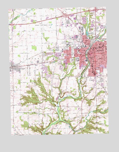
Richmond, IN USGS Topographic Map
Click on map above to begin viewing in our Map Viewer.

This topographic map contains these locations and features:
Feature Name Type Latitude Longitude GNIS ID View Map
Boston CreekStreamN39.7525°W84.9186°431370View Map
Calvary ChurchChurchN39.8214°W84.9044°431982View Map
CentervillePopulated PlaceN39.8178°W84.9964°432346View Map
Centerville Fire and RescueBuildingN39.8135°W84.9967°2626017View Map
Centerville Police DeptBuildingN39.8179°W84.9945°2758210View Map
City of RichmondCivilN39.8318°W84.8904°2396366View Map
Clear CreekStreamN39.8081°W84.9277°432615View Map
Clear Creek ParkParkN39.8325°W84.9197°432619View Map
Crown Hill CemeteryCemeteryN39.8221°W84.9999°433212View Map
Crown Hill CemeteryCemeteryN39.8231°W84.9991°433213View Map
Dennis David Worth Junior High SchoolSchoolN39.8320°W84.9116°433475View Map
Earlham CemeteryCemeteryN39.8242°W84.9189°433862View Map
Earlham CollegeSchoolN39.8234°W84.9136°433863View Map
East HavenPopulated PlaceN39.8392°W84.9308°433909View Map
Elkhorn CreekStreamN39.7639°W84.9369°434084View Map
Elkhorn LakesLakeN39.7501°W84.9573°434088View Map
Finley SchoolSchoolN39.8256°W84.8963°434492View Map
Fork CreekStreamN39.8614°W84.9980°434671View Map
Gephart DitchCanalN39.8402°W84.9969°2612578View Map
Glen White DamDamN39.7817°W84.9883°447208View Map
Glen White LakeReservoirN39.7814°W84.9891°447207View Map
GreenwoodPopulated PlaceN39.8123°W84.8880°449057View Map
Hibberd Junior High SchoolSchoolN39.8148°W84.8875°436084View Map
Highland Heights Elementary SchoolSchoolN39.8739°W84.8872°436170View Map
Hoover Bulla CemeteryCemeteryN39.8512°W84.8816°436419View Map
King CemeteryCemeteryN39.8470°W84.9233°437322View Map
Lick CreekStreamN39.7825°W84.9361°449508View Map
Lutherania CemeteryCemeteryN39.8017°W84.9077°438418View Map
Middle Fork East Fork Whitewater RiverStreamN39.8425°W84.8886°439099View Map
Middle Fork Reservoir DamDamN39.8545°W84.8752°447234View Map
Nicholson SchoolSchoolN39.8378°W84.8844°440162View Map
Pentecost Airport (historical)AirportN39.8562°W84.9722°2676882View Map
Reid HospitalHospitalN39.8646°W84.8841°441884View Map
Rich CreekStreamN39.8639°W84.9947°441943View Map
RichmondPopulated PlaceN39.8289°W84.8902°441976View Map
Richmond Fire Department Station 1BuildingN39.8272°W84.8950°2626004View Map
Richmond Fire Department Station 2BuildingN39.8645°W84.8898°2701486View Map
Richmond Fire Department Station 4BuildingN39.8140°W84.8915°2701484View Map
Richmond Fire Department Station 5BuildingN39.8290°W84.9299°2701485View Map
Richmond Fire Department Station 6BuildingN39.8494°W84.9077°2701481View Map
Richmond Police DepartmentBuildingN39.8300°W84.8959°2758132View Map
Richmond Senior High SchoolSchoolN39.8223°W84.9016°447514View Map
Richmond State HospitalHospitalN39.8383°W84.9257°441978View Map
Richmond State Hospital FarmHospitalN39.8567°W84.9533°452391View Map
Rural / Metro Ambulance - RichmondBuildingN39.8376°W84.8939°2719430View Map
Saint Andrews CemeteryCemeteryN39.8062°W84.9032°442466View Map
Saint Andrews SchoolSchoolN39.8248°W84.8952°442470View Map
Saint Johns ChurchChurchN39.8214°W84.8925°442594View Map
Saint Pauls ChurchChurchN39.8231°W84.8925°442779View Map
Saint Pauls ChurchChurchN39.8273°W84.8772°442780View Map
Short CreekStreamN39.7867°W84.9097°443448View Map
Smith CreekStreamN39.7506°W84.9586°443673View Map
South RichmondPopulated PlaceN39.8006°W84.8883°449062View Map
Spring GrovePopulated PlaceN39.8484°W84.8941°443979View Map
Spring Grove HeightsPopulated PlaceN39.8434°W84.8925°443981View Map
Starr Elementary SchoolSchoolN39.8331°W84.8758°444081View Map
Starr ParkParkN39.8331°W84.8813°444080View Map
Tea CreekStreamN39.7567°W84.9047°444610View Map
Town of CentervilleCivilN39.8297°W84.9935°2396637View Map
Town of Spring GroveCivilN39.8472°W84.8912°2397673View Map
Township of CenterCivilN39.8228°W84.9981°453196View Map
Township of WayneCivilN39.8412°W84.8754°454042View Map
Vaile Elementary SchoolSchoolN39.8242°W84.8841°445185View Map
Warner SchoolSchoolN39.8325°W84.8933°445477View Map
Wayne County SheriffBuildingN39.8284°W84.8972°2758358View Map
WECI-FM (Richmond)TowerN39.8228°W84.9108°448962View Map
West Fork East Fork Whitewater RiverStreamN39.8353°W84.8958°445746View Map
White Airport (historical)AirportN39.7747°W84.9240°2677099View Map
WKBV-AM (Richmond)TowerN39.8250°W84.9305°448450View Map
WRIA-FM (Richmond)TowerN39.8250°W84.9305°448961View Map

Note: Coordinates in the location and feature list above are referenced to NAD83 datum.


Copyright (C) 2008-2024 Ryan Niemi / Sunset Dynamics ... All Rights Reserved