TopoQuest Logo
Do you find TopoQuest useful?
Help keep TopoQuest running and adding new maps/features by donating!
Bitcoin:  19c7KJd3qBynnjoSw5npx9KScwjBe4ifkT
Litecoin:  LXs6TkuXGGXo1vDsWCkWVdjQX94eUKd6ui
Home View Maps Find Maps Find Places Resources & Links


Red Hill, Alabama Topographic Map

USGS Map Title: Red Hill, AL
USGS Map MRC: 32085F8
DRG (GeoTIFF) Download: o32085f8.tif


Neighboring USGS Topographic Map Quads:


  Equality, AL  
32086G1
 

  Our Town, AL  
32085G8
 

  Dadeville, AL  
32085G7
 

  Eclectic, AL  
32086F1
 

  Red Hill, AL  
32085F8
 

  Ponders, AL  
32085F7
 

  Claud, AL  
32086E1
 

  Tallassee, AL  
32085E8
 

  Carrville, AL  
32085E7


Map MRC Location:

N33°
W86°
N33°
W85°
H8 H7 H6 H5 H4 H3 H2 H1
G8 G7 G6 G5 G4 G3 G2 G1
F8 F7 F6 F5 F4 F3 F2 F1
E8 E7 E6 E5 E4 E3 E2 E1
D8 D7 D6 D5 D4 D3 D2 D1
C8 C7 C6 C5 C4 C3 C2 C1
B8 B7 B6 B5 B4 B3 B2 B1
A8 A7 A6 A5 A4 A3 A2 A1
N32°
W86°
N32°
W85°

Red Hill, AL USGS 1:24K Topographic Map Preview:
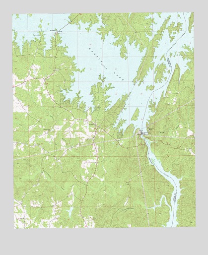
Red Hill, AL USGS Topographic Map
Click on map above to begin viewing in our Map Viewer.

This topographic map contains these locations and features:
Feature Name Type Latitude Longitude GNIS ID View Map
Asbury School (historical)SchoolN32.6299°W85.9452°137134View Map
Bethlehem (historical)LocaleN32.7162°W85.9705°137143View Map
Beulah Baptist ChurchChurchN32.6310°W85.9930°114183View Map
Camp Dixie (historical)LocaleN32.7474°W85.9461°137153View Map
Camp ExchangeLocaleN32.6743°W85.9263°137154View Map
Channahatchee CreekStreamN32.6337°W85.8925°155022View Map
Channahatchee Hunting ClubLocaleN32.6443°W85.9516°154144View Map
Cherokee BluffsPopulated PlaceN32.6821°W85.9063°115998View Map
Church in the PinesChurchN32.7385°W85.9691°116115View Map
County Line CemeteryCemeteryN32.7429°W85.9188°137174View Map
Crystal Island MarinaLocaleN32.7135°W85.9375°137177View Map
Dixie Sailing ClubLocaleN32.7082°W85.9122°137180View Map
Double Bridges Ferry (historical)CrossingN32.6762°W85.9097°137403View Map
Gold BranchStreamN32.6518°W85.9502°119083View Map
Irma (historical)LocaleN32.7235°W85.9380°137230View Map
Kailaidshi (historical)LocaleN32.7307°W85.9833°158144View Map
Kelsey School (historical)SchoolN32.7174°W85.9680°137238View Map
KowaligaPopulated PlaceN32.7401°W85.9691°151968View Map
Kowaliga MarinaLocaleN32.7399°W85.9689°137243View Map
Kowaliga Volunteer Fire DepartmentBuildingN32.7270°W85.9835°2691218View Map
Lovejoy CemeteryCemeteryN32.7035°W85.9400°137251View Map
Martin DamDamN32.6803°W85.9108°122326View Map
Martin LakeReservoirN32.6800°W85.9114°122333View Map
McCarty Ferry (historical)CrossingN32.7257°W85.8880°137469View Map
Meltons Mill (historical)LocaleN32.6818°W85.8922°137473View Map
Pleasant Hill ChurchChurchN32.6301°W85.9452°124996View Map
Prospect CemeteryCemeteryN32.7379°W85.9805°125303View Map
Prospect Methodist ChurchChurchN32.7299°W85.9825°153071View Map
Red HillPopulated PlaceN32.6851°W85.9430°155214View Map
Red Hill School (historical)SchoolN32.6774°W85.9444°137296View Map
Red Hill Volunteer Fire DepartmentBuildingN32.6777°W85.9446°2691354View Map
Refuge Baptist ChurchChurchN32.6837°W85.9436°137300View Map
Rock Hill School (historical)SchoolN32.6374°W85.9916°137303View Map
Rocky PointCapeN32.7051°W85.9591°137306View Map
Shiloh Baptist ChurchChurchN32.7174°W85.9680°137237View Map
Watson ChapelChurchN32.6740°W85.9836°155295View Map
Watson Chapel CemeteryCemeteryN32.6821°W85.9761°128639View Map
Whispering Springs CampgroundLocaleN32.6974°W85.9658°155411View Map
Wind CreekStreamN32.6749°W85.9058°129107View Map

Note: Coordinates in the location and feature list above are referenced to NAD83 datum.


Copyright (C) 2008-2024 Ryan Niemi / Sunset Dynamics ... All Rights Reserved