TopoQuest Logo
Do you find TopoQuest useful?
Help keep TopoQuest running and adding new maps/features by donating!
Bitcoin:  19c7KJd3qBynnjoSw5npx9KScwjBe4ifkT
Litecoin:  LXs6TkuXGGXo1vDsWCkWVdjQX94eUKd6ui
Home View Maps Find Maps Find Places Resources & Links


Needles NE, Arizona Topographic Map

USGS Map Title: Needles NE, AZ
USGS Map MRC: 34114H5
DRG (GeoTIFF) Download: o34114h5.tif


Neighboring USGS Topographic Map Quads:


  Mount Manchester, CA  
35114A6
 

  Davis Dam SE, AZ  
35114A5
 

  Oatman, AZ  
35114A4
 

  Needles NW, CA  
34114H6
 

  Needles NE, AZ  
34114H5
 

  Boundary Cone, AZ  
34114H4
 

  Needles SW, CA  
34114G6
 

  Needles, CA  
34114G5
 

  Warm Springs SW, AZ  
34114G4


Map MRC Location:

N35°
W115°
N35°
W114°
H8 H7 H6 H5 H4 H3 H2 H1
G8 G7 G6 G5 G4 G3 G2 G1
F8 F7 F6 F5 F4 F3 F2 F1
E8 E7 E6 E5 E4 E3 E2 E1
D8 D7 D6 D5 D4 D3 D2 D1
C8 C7 C6 C5 C4 C3 C2 C1
B8 B7 B6 B5 B4 B3 B2 B1
A8 A7 A6 A5 A4 A3 A2 A1
N34°
W115°
N34°
W114°

Needles NE, AZ USGS 1:24K Topographic Map Preview:
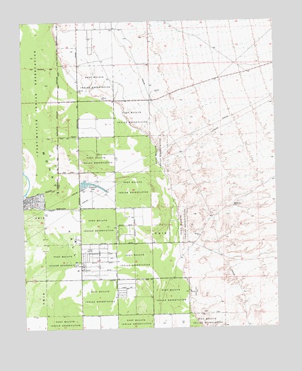
Needles NE, AZ USGS Topographic Map
Click on map above to begin viewing in our Map Viewer.

This topographic map contains these locations and features:
Feature Name Type Latitude Longitude GNIS ID View Map
Christian Joy Church of the NazareneChurchN34.9964°W114.5913°2670747View Map
Cimarron LakeReservoirN34.9337°W114.5908°2942View Map
Desert Lakes Golf CourseLocaleN34.9876°W114.5851°2670245View Map
Desert Lawn CemeteryCemeteryN34.8896°W114.5428°3860View Map
Eagle AirparkAirportN34.8917°W114.6166°45315View Map
El Rio Golf and Country ClubLocaleN34.9610°W114.5896°2670246View Map
First Southern Baptist ChurchChurchN34.9119°W114.6004°2671007View Map
Fort Mohave Elementary SchoolSchoolN34.9964°W114.5882°2543531View Map
Fort Mojave Mesa Fire Department Station 91 HeadquartersBuildingN34.9967°W114.5709°2672484View Map
Fort Mojave ReservationCivilN34.9429°W114.6094°24003View Map
Los Lagos Golf ClubLocaleN34.9709°W114.5709°2670576View Map
Mesquite CreekPopulated PlaceN34.9667°W114.5686°1853162View Map
Mesquite Creek Census Designated PlaceCensusN34.9606°W114.5714°2408824View Map
MilltownLocaleN34.9244°W114.5219°8081View Map
Mohave County Library District South Mohave Valley Community LibraryBuildingN34.9186°W114.5985°2669447View Map
Mohave ValleyPopulated PlaceN34.9331°W114.5889°1866989View Map
Mohave Valley Census Designated PlaceCensusN34.9008°W114.5733°2408851View Map
Mohave Valley Elementary SchoolSchoolN34.9106°W114.6006°44800View Map
Mohave Valley Fire DepartmentBuildingN34.9100°W114.5994°2672347View Map
Mohave Valley Junior High SchoolSchoolN34.9659°W114.5549°2543662View Map
Mohave Valley Post OfficePost OfficeN34.9189°W114.5983°44954View Map
Mohave Valley United Methodist ChurchChurchN34.9829°W114.5946°2671238View Map
Mojave Ranch EstatesPopulated PlaceN34.9428°W114.5908°1853163View Map
Mojave Ranch Estates Census Designated PlaceCensusN34.9449°W114.5906°2408854View Map
River Valley High SchoolSchoolN34.8941°W114.5699°2543599View Map
Spears LakeFlatN34.9289°W114.6066°23226View Map
Squaw BeachBeachN34.9167°W114.5564°23228View Map
Willow Springs Golf CourseLocaleN34.9226°W114.5993°2669926View Map
Willow ValleyPopulated PlaceN34.9119°W114.6066°1866993View Map
Willow Valley Census Designated PlaceCensusN34.9295°W114.6155°2409600View Map

Note: Coordinates in the location and feature list above are referenced to NAD83 datum.


Copyright (C) 2008-2024 Ryan Niemi / Sunset Dynamics ... All Rights Reserved