TopoQuest Logo
Do you find TopoQuest useful?
Help keep TopoQuest running and adding new maps/features by donating!
Bitcoin:  19c7KJd3qBynnjoSw5npx9KScwjBe4ifkT
Litecoin:  LXs6TkuXGGXo1vDsWCkWVdjQX94eUKd6ui
Home View Maps Find Maps Find Places Resources & Links


Minnehaha Creek South, Montana Topographic Map

USGS Map Title: Minnehaha Creek South, MT
USGS Map MRC: 45107H1
DRG (GeoTIFF) Download: o45107h1.tif


Neighboring USGS Topographic Map Quads:


  South Bear Creek, MT  
46107A2
 

  Minnehaha Creek North, MT  
46107A1
 

  Griffin Coulee SW, MT  
46106A8
 

  Iron Spring, MT  
45107H2
 

  Minnehaha Creek South, MT  
45107H1
 

  McClure Creek, MT  
45106H8
 

  Iron Spring SW, MT  
45107G2
 

  Wolf School, MT  
45107G1
 

  Sarpy School, MT  
45106G8


Map MRC Location:

N46°
W108°
N46°
W107°
H8 H7 H6 H5 H4 H3 H2 H1
G8 G7 G6 G5 G4 G3 G2 G1
F8 F7 F6 F5 F4 F3 F2 F1
E8 E7 E6 E5 E4 E3 E2 E1
D8 D7 D6 D5 D4 D3 D2 D1
C8 C7 C6 C5 C4 C3 C2 C1
B8 B7 B6 B5 B4 B3 B2 B1
A8 A7 A6 A5 A4 A3 A2 A1
N45°
W108°
N45°
W107°

Minnehaha Creek South, MT USGS 1:24K Topographic Map Preview:
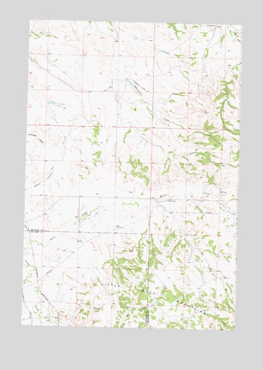
Minnehaha Creek South, MT USGS Topographic Map
Click on map above to begin viewing in our Map Viewer.

This topographic map contains these locations and features:
Feature Name Type Latitude Longitude GNIS ID View Map
02N37E01ADAB01 SpringSpringN45.9528°W107.0537°813539View Map
02N37E01ADBA01 SpringSpringN45.9525°W107.0550°813536View Map
02N37E03BAAA01 SpringSpringN45.9567°W107.1048°813561View Map
02N37E09ACCB01 SpringSpringN45.9322°W107.1237°813433View Map
02N37E09BCAD01 WellWellN45.9378°W107.1217°813462View Map
02N37E09DDDD01 WellWellN45.9283°W107.1151°813407View Map
02N37E10DCBC01 WellWellN45.9305°W107.1031°813423View Map
02N37E11DCCB01 WellWellN45.9294°W107.0823°813413View Map
02N37E12CDAD01 WellWellN45.9305°W107.0639°813422View Map
02N37E13CCBC01 WellWellN45.9164°W107.0717°813348View Map
02N37E14ABBB01 WellWellN45.9255°W107.0748°813390View Map
02N37E14CBCC01 SpringSpringN45.9175°W107.0928°813355View Map
02N37E15DAAA01 WellWellN45.9197°W107.0939°813360View Map
02N37E16DCCD01 WellWellN45.9147°W107.1228°813337View Map
02N37E22DBAB01 WellWellN45.9061°W107.1006°813254View Map
02N37E23BBCD01 SpringSpringN45.9100°W107.0914°813296View Map
02N37E24CBCC01 WellWellN45.9036°W107.0725°813229View Map
02N37E25DCAD01 SpringSpringN45.8897°W107.0584°813118View Map
02N37E27DABC01 WellWellN45.8905°W107.0981°813126View Map
02N37E27DCBA01 WellWellN45.8878°W107.1026°813093View Map
02N37E34BCDA01 WellWellN45.8786°W107.1098°813015View Map
02N37E34DABD01 WellWellN45.8761°W107.0970°812991View Map
02N37E34DACB01 WellWellN45.8753°W107.0978°812983View Map
02N38E04CCCC01 SpringSpringN45.9430°W107.0103°813492View Map
02N38E05ADBA01 SpringSpringN45.9522°W107.0145°813533View Map
02N38E06BDCA01 SpringSpringN45.9511°W107.0450°813524View Map
02N38E07DCCC01 WellWellN45.9283°W107.0412°813406View Map
02N38E08ACDA01 SpringSpringN45.9369°W107.0167°813456View Map
02N38E08DCCA01 WellWellN45.9297°W107.0198°813418View Map
02N38E16ADAC01 SpringSpringN45.9230°W107.0028°813377View Map
02N38E16ADAC01 SpringSpringN45.9236°W107.0025°813382View Map
02N38E17AAAA01 WellWellN45.9275°W107.0120°813401View Map
02N38E18ABBB01 WellWellN45.9272°W107.0412°813399View Map
02N38E18ACDB01 WellWellN45.9222°W107.0389°813372View Map
02N38E18BBCC01 SpringSpringN45.9255°W107.0503°813389View Map
02N38E18DACD01 WellWellN45.9172°W107.0345°813353View Map
02N38E19ACAD01 SpringSpringN45.9083°W107.0373°813283View Map
02N38E19ACDA01 SpringSpringN45.9083°W107.0367°813282View Map
02N38E20BDAC01 WellWellN45.9083°W107.0248°813281View Map
02N38E20CDCA01 SpringSpringN45.9008°W107.0245°813210View Map
02N38E20DBAC01 SpringSpringN45.9075°W107.0192°813272View Map
02N38E20DDCA01 WellWellN45.9000°W107.0145°813204View Map
02N38E28ABDB01 WellWellN45.8969°W107.0075°813182View Map
02N38E28ABDB02 WellWellN45.8961°W107.0070°813178View Map
02N38E29ABBD01 SpringSpringN45.8975°W107.0206°813186View Map
02N38E29DDCB01 WellWellN45.8861°W107.0167°813085View Map
02N38E29DDCB02 WellWellN45.8861°W107.0167°813086View Map
02N38E29DDCB03 WellWellN45.8858°W107.0167°813080View Map
02N38E30AABD01 SpringSpringN45.8980°W107.0345°813189View Map
02N38E30BBCA01 SpringSpringN45.8969°W107.0506°813183View Map
02N38E30BCCC01 SpringSpringN45.8919°W107.0517°813135View Map
02N38E30BDDD01 WellWellN45.8922°W107.0423°813139View Map
02N38E30BDDD02 SpringSpringN45.8919°W107.0420°813134View Map
02N38E32ABDB01 WellWellN45.8828°W107.0195°813047View Map
03N37E25CBDB01 WellWellN45.9764°W107.0695°813658View Map
03N37E26DACD01 WellWellN45.9758°W107.0762°813656View Map
03N37E26DDBB01 WellWellN45.9744°W107.0776°813652View Map
03N37E35CDBC01 WellWellN45.9594°W107.0873°813579View Map
03N37E35CDBD01 WellWellN45.9594°W107.0859°813578View Map
03N37E36CDDA01 SpringSpringN45.9580°W107.0631°813570View Map
03N38E20AAAD01 WellWellN45.9992°W107.0109°813720View Map
03N38E20AABD01 WellWellN45.9992°W107.0137°813721View Map
03N38E20ABAA01 WellWellN45.9997°W107.0162°813725View Map
03N38E20ABAD01 WellWellN45.9989°W107.0162°813719View Map
03N38E20ABAD02 WellWellN45.9997°W107.0159°813724View Map
03N38E32CBCC01 WellWellN45.9611°W107.0306°813583View Map
East Fork Sarpy CreekStreamN45.8783°W107.1151°771070View Map
Hays RanchLocaleN45.9272°W107.0420°772274View Map
Horse CreekStreamN45.9103°W107.1245°772544View Map
Horse Creek School (historical)SchoolN45.9305°W107.0687°1721524View Map
Lackey School (historical)SchoolN45.9708°W107.0734°1721525View Map
McRae (historical)Populated PlaceN45.8783°W107.1201°1716507View Map
McRae Post Office (historical)Post OfficeN45.8783°W107.1201°1716508View Map
Pleasant CreekStreamN45.8928°W107.1217°775279View Map
Wilson RanchLocaleN45.9992°W107.0162°778572View Map
Yellow Minni Stone DamDamN45.9767°W107.0689°798801View Map
Yellow Sarpy DamDamN45.9667°W107.1123°798800View Map

Note: Coordinates in the location and feature list above are referenced to NAD83 datum.


Copyright (C) 2008-2024 Ryan Niemi / Sunset Dynamics ... All Rights Reserved