TopoQuest Logo
Do you find TopoQuest useful?
Help keep TopoQuest running and adding new maps/features by donating!
Bitcoin:  19c7KJd3qBynnjoSw5npx9KScwjBe4ifkT
Litecoin:  LXs6TkuXGGXo1vDsWCkWVdjQX94eUKd6ui
Home View Maps Find Maps Find Places Resources & Links


Marion, Kansas Topographic Map

USGS Map Title: Marion, KS
USGS Map MRC: 38097C1
DRG (GeoTIFF) Download: o38097c1.tif


Neighboring USGS Topographic Map Quads:


  Durham, KS  
38097D2
 

  Pilsen, KS  
38097D1
 

  Lincolnville, KS  
38096D8
 

  Hillsboro, KS  
38097C2
 

  Marion, KS  
38097C1
 

  Lincolnville SW, KS  
38096C8
 

  Peabody NW, KS  
38097B2
 

  Peabody, KS  
38097B1
 

  Florence, KS  
38096B8


Map MRC Location:

N39°
W98°
N39°
W97°
H8 H7 H6 H5 H4 H3 H2 H1
G8 G7 G6 G5 G4 G3 G2 G1
F8 F7 F6 F5 F4 F3 F2 F1
E8 E7 E6 E5 E4 E3 E2 E1
D8 D7 D6 D5 D4 D3 D2 D1
C8 C7 C6 C5 C4 C3 C2 C1
B8 B7 B6 B5 B4 B3 B2 B1
A8 A7 A6 A5 A4 A3 A2 A1
N38°
W98°
N38°
W97°

Marion, KS USGS 1:24K Topographic Map Preview:
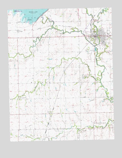
Marion, KS USGS Topographic Map
Click on map above to begin viewing in our Map Viewer.

This topographic map contains these locations and features:
Feature Name Type Latitude Longitude GNIS ID View Map
AulnePopulated PlaceN38.2761°W97.0767°477370View Map
Aulne United Methodist ChurchChurchN38.2759°W97.0767°2689350View Map
Bown Corby Elementary SchoolSchoolN38.3514°W97.0211°480779View Map
CanadaPopulated PlaceN38.3542°W97.1128°477365View Map
Canada CemeteryCemeteryN38.3629°W97.1128°477363View Map
Canada School (historical)SchoolN38.3631°W97.1136°482937View Map
City of MarionCivilN38.3538°W97.0082°485619View Map
Claney CemeteryCemeteryN38.2905°W97.0367°477369View Map
Clear CreekStreamN38.3617°W97.0217°482742View Map
Dickerson School (historical)SchoolN38.2906°W97.0214°482947View Map
Eastmoor United Methodist ChurchChurchN38.3479°W97.0056°2690415View Map
Emmanuel Baptist ChurchChurchN38.3499°W97.0240°2690416View Map
Good News Christian Fellowship ChurchChurchN38.3452°W97.0083°2690417View Map
Hillsboro Cove Public Use AreaParkN38.3628°W97.1003°477364View Map
Holy Family Catholic ChurchChurchN38.3529°W97.0132°2690418View Map
Kansas Department of Transportation District 2 Area 3 ShopBuildingN38.3622°W97.0135°2693146View Map
MarionPopulated PlaceN38.3483°W97.0172°477366View Map
Marion Christian ChurchChurchN38.3496°W97.0164°2690419View Map
Marion City HallBuildingN38.3494°W97.0205°2693362View Map
Marion City LibraryBuildingN38.3461°W97.0195°2692584View Map
Marion Country ClubLocaleN38.3447°W97.0016°2694585View Map
Marion CountyCivilN38.3589°W97.0969°485022View Map
Marion County CourthouseBuildingN38.3472°W97.0196°2625080View Map
Marion County Emergency Medical ServicesBuildingN38.3484°W97.0180°2696549View Map
Marion County Health DepartmentBuildingN38.3484°W97.0203°2695031View Map
Marion County JailBuildingN38.3472°W97.0195°2504358View Map
Marion County Sheriff's OfficeBuildingN38.3472°W97.0196°2504092View Map
Marion DamDamN38.3689°W97.0850°477245View Map
Marion Elementary SchoolSchoolN38.3506°W97.0059°480781View Map
Marion Fire DepartmentBuildingN38.3489°W97.0181°2111593View Map
Marion High SchoolSchoolN38.3481°W97.0146°480780View Map
Marion Middle SchoolSchoolN38.3473°W97.0145°2497525View Map
Marion MuseumBuildingN38.3484°W97.0161°2694929View Map
Marion Police DepartmentBuildingN38.3489°W97.0181°2503784View Map
Marion Post OfficePost OfficeN38.3479°W97.0185°2693845View Map
Marion Presbyterian ChurchChurchN38.3504°W97.0166°2690420View Map
Marion ReservoirReservoirN38.3689°W97.0850°482716View Map
Marion Senior CenterBuildingN38.3460°W97.0205°2692822View Map
Marion Wastewater PlantLocaleN38.3355°W97.0208°2692014View Map
Mistar School (historical)SchoolN38.3339°W97.0770°482980View Map
Mud CreekStreamN38.3386°W97.0220°477367View Map
North Cottonwood RiverStreamN38.3570°W97.0706°477241View Map
Our Lady of Perpetual Help ChurchChurchN38.2906°W97.1134°477368View Map
Our Savior Lutheran ChurchChurchN38.3448°W97.0123°2690421View Map
Saint Luke Hospital - MarionHospitalN38.3428°W97.0107°2499136View Map
South Cottonwood RiverStreamN38.3570°W97.0706°477240View Map
Spring BranchStreamN38.3061°W97.0159°477360View Map
Sunflower School (historical)SchoolN38.3045°W97.0489°483009View Map
Sunnyside School (historical)SchoolN38.3045°W97.1003°483011View Map
Team Marketing Alliance Grain Elevator Number 24LocaleN38.3451°W97.0195°2695392View Map
Team Marketing Alliance Grain Elevator Number 7LocaleN38.3529°W97.1119°2695383View Map
Township of WilsonCivilN38.3046°W97.0955°477362View Map
Valley United Methodist ChurchChurchN38.3493°W97.0199°2690422View Map

Note: Coordinates in the location and feature list above are referenced to NAD83 datum.


Copyright (C) 2008-2024 Ryan Niemi / Sunset Dynamics ... All Rights Reserved