TopoQuest Logo
Do you find TopoQuest useful?
Help keep TopoQuest running and adding new maps/features by donating!
Bitcoin:  19c7KJd3qBynnjoSw5npx9KScwjBe4ifkT
Litecoin:  LXs6TkuXGGXo1vDsWCkWVdjQX94eUKd6ui
Home View Maps Find Maps Find Places Resources & Links


Lavalette, West Virginia Topographic Map

USGS Map Title: Lavalette, WV
USGS Map MRC: 38082C4
DRG (GeoTIFF) Download: o38082c4.tif


Neighboring USGS Topographic Map Quads:


  Catlettsburg, KY  
38082D5
 

  Huntington, WV  
38082D4
 

  Barboursville, WV  
38082D3
 

  Burnaugh, KY  
38082C5
 

  Lavalette, WV  
38082C4
 

  Winslow, WV  
38082C3
 

  Prichard, WV  
38082B5
 

  Wayne, WV  
38082B4
 

  Nestlow, WV  
38082B3


Map MRC Location:

N39°
W83°
N39°
W82°
H8 H7 H6 H5 H4 H3 H2 H1
G8 G7 G6 G5 G4 G3 G2 G1
F8 F7 F6 F5 F4 F3 F2 F1
E8 E7 E6 E5 E4 E3 E2 E1
D8 D7 D6 D5 D4 D3 D2 D1
C8 C7 C6 C5 C4 C3 C2 C1
B8 B7 B6 B5 B4 B3 B2 B1
A8 A7 A6 A5 A4 A3 A2 A1
N38°
W83°
N38°
W82°

Lavalette, WV USGS 1:24K Topographic Map Preview:
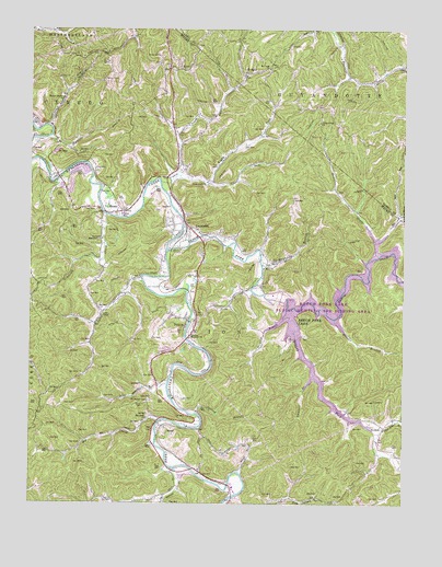
Lavalette, WV USGS Topographic Map
Click on map above to begin viewing in our Map Viewer.

This topographic map contains these locations and features:
Feature Name Type Latitude Longitude GNIS ID View Map
ArdelPopulated PlaceN38.2706°W82.4554°1553741View Map
Beech ForkStreamN38.3168°W82.4540°1535528View Map
Beech Fork LakeReservoirN38.3159°W82.3829°1535532View Map
Beech Fork Lake DamDamN38.3051°W82.4221°1559324View Map
Beech Fork Lake Wildlife Management AreaParkN38.3040°W82.3824°2043508View Map
Beulah ChurchChurchN38.3651°W82.4507°1535740View Map
Big CreekStreamN38.2718°W82.4565°1535818View Map
Big Creek ChurchChurchN38.2726°W82.4607°1535828View Map
Bloss CemeteryCemeteryN38.3063°W82.4456°2586381View Map
BootonPopulated PlaceN38.2706°W82.3815°1553951View Map
Camp CreekStreamN38.3348°W82.4565°1536910View Map
Camp Creek ChurchChurchN38.3348°W82.4413°1536919View Map
Cherry BranchStreamN38.2518°W82.4127°1728911View Map
Childers BranchStreamN38.2843°W82.4049°1537311View Map
DicksonPopulated PlaceN38.2981°W82.4471°1554301View Map
District 1CivilN38.3714°W82.4025°1928205View Map
Falls BranchStreamN38.3068°W82.4260°1538873View Map
Fisher Bowen BranchStreamN38.2687°W82.3829°1538984View Map
Florence Memorial United Methodist ChurchChurchN38.2937°W82.4465°1539098View Map
Garrett CreekStreamN38.2595°W82.4532°1539346View Map
Haneys BranchStreamN38.3495°W82.4935°1539904View Map
Haneys Branch ChurchChurchN38.3567°W82.4893°1539905View Map
HodgesPopulated PlaceN38.3626°W82.4288°1540332View Map
LavalettePopulated PlaceN38.3229°W82.4468°1554920View Map
Lavalette Census Designated PlaceCensusN38.3224°W82.4479°2586842View Map
Lavalette Elementary SchoolSchoolN38.3219°W82.4443°2088244View Map
Lavalette Post OfficePost OfficeN38.3234°W82.4495°1728970View Map
Lavalette Volunteer Fire DepartmentBuildingN38.3373°W82.4518°2577519View Map
Long BranchStreamN38.3593°W82.4343°1542353View Map
Luther Bowen CemeteryCemeteryN38.3250°W82.4770°2728234View Map
Lynn ChapelChurchN38.2995°W82.4760°1542637View Map
Lynn CreekStreamN38.3087°W82.4624°1542640View Map
Macedonia ChurchChurchN38.3162°W82.3846°1542663View Map
Mary Davis BranchStreamN38.3090°W82.3760°1542834View Map
Mays BranchStreamN38.3131°W82.4224°1542910View Map
Mays CemeteryCemeteryN38.3143°W82.4193°1542911View Map
Mays ChurchChurchN38.3120°W82.4218°1542913View Map
Millers ForkStreamN38.3029°W82.4138°1543403View Map
Mount Union ChurchChurchN38.3645°W82.4207°1543775View Map
Mount Union Church-Chatterton CemeteryCemeteryN38.3649°W82.4190°2726445View Map
Mount Vernon CemeteryCemeteryN38.2770°W82.4596°1543786View Map
Newcomb CreekStreamN38.3262°W82.4746°1544145View Map
Newcomb Missionary ChurchChurchN38.3195°W82.4760°1544147View Map
Plymale BranchStreamN38.3467°W82.4929°1545077View Map
Price CreekStreamN38.3154°W82.3829°1545257View Map
Right Fork Camp CreekStreamN38.3368°W82.4510°1545621View Map
Right Fork Garrett CreekStreamN38.2515°W82.4540°1728993View Map
Rubens BranchStreamN38.2987°W82.3979°1546128View Map
Shoal BranchStreamN38.2587°W82.4296°1546697View Map
ShoalsPopulated PlaceN38.3270°W82.4752°1555615View Map
Shoals Post OfficePost OfficeN38.3266°W82.4725°1728996View Map
Smith CemeteryCemeteryN38.2762°W82.4621°1546970View Map
Spring BranchStreamN38.2740°W82.4443°1547173View Map
Stephenson Family CemeteryCemeteryN38.3182°W82.4900°2728238View Map
Stowers BranchStreamN38.2990°W82.4149°1547539View Map
Sugarwood Golf ClubLocaleN38.3066°W82.4543°2634196View Map
Twin Silos at Lavalette Golf CourseLocaleN38.3322°W82.4577°2634224View Map
Union DistrictCivilN38.2694°W82.4148°1928392View Map
Walnut Gap ChurchChurchN38.3506°W82.4032°1548756View Map
Wayne Elementary SchoolSchoolN38.2543°W82.4289°1729016View Map

Note: Coordinates in the location and feature list above are referenced to NAD83 datum.


Copyright (C) 2008-2024 Ryan Niemi / Sunset Dynamics ... All Rights Reserved