TopoQuest Logo
Do you find TopoQuest useful?
Help keep TopoQuest running and adding new maps/features by donating!
Bitcoin:  19c7KJd3qBynnjoSw5npx9KScwjBe4ifkT
Litecoin:  LXs6TkuXGGXo1vDsWCkWVdjQX94eUKd6ui
Home View Maps Find Maps Find Places Resources & Links


Lake Lurleen, Alabama Topographic Map

USGS Map Title: Lake Lurleen, AL
USGS Map MRC: 33087C6
DRG (GeoTIFF) Download: o33087c6.tif


Neighboring USGS Topographic Map Quads:


  Brownville, AL  
33087D7
 

  Gin Creek, AL  
33087D6
 

  Lake Tuscaloosa North, AL  
33087D5
 

  Elrod, AL  
33087C7
 

  Lake Lurleen, AL  
33087C6
 

  Lake Tuscaloosa South, AL  
33087C5
 

  Romulus, AL  
33087B7
 

  Coker, AL  
33087B6
 

  Tuscaloosa, AL  
33087B5


Map MRC Location:

N34°
W88°
N34°
W87°
H8 H7 H6 H5 H4 H3 H2 H1
G8 G7 G6 G5 G4 G3 G2 G1
F8 F7 F6 F5 F4 F3 F2 F1
E8 E7 E6 E5 E4 E3 E2 E1
D8 D7 D6 D5 D4 D3 D2 D1
C8 C7 C6 C5 C4 C3 C2 C1
B8 B7 B6 B5 B4 B3 B2 B1
A8 A7 A6 A5 A4 A3 A2 A1
N33°
W88°
N33°
W87°

Lake Lurleen, AL USGS 1:24K Topographic Map Preview:
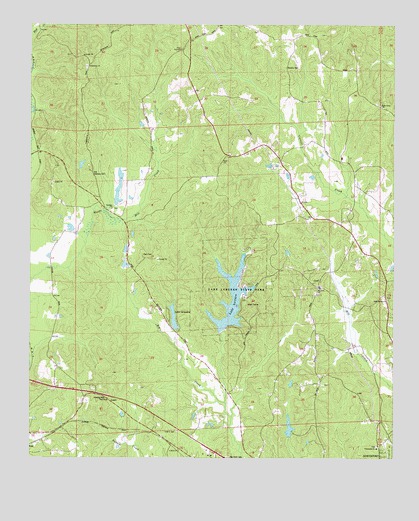
Lake Lurleen, AL USGS Topographic Map
Click on map above to begin viewing in our Map Viewer.

This topographic map contains these locations and features:
Feature Name Type Latitude Longitude GNIS ID View Map
African Methodist Episcopal ChurchChurchN33.2523°W87.6986°150846View Map
African Methodist Episcopal Church CemeteryCemeteryN33.2576°W87.6995°150845View Map
Arnedra SubdivisionPopulated PlaceN33.2912°W87.7022°1700469View Map
Bel Air EstatesPopulated PlaceN33.2621°W87.6878°1700470View Map
Bethabara School (historical)SchoolN33.3709°W87.7228°147854View Map
Bethany (historical)LocaleN33.3179°W87.7175°147855View Map
Bethany Baptist ChurchChurchN33.3221°W87.7222°113996View Map
Bethany CemeteryCemeteryN33.3221°W87.7211°147856View Map
Bethany School (historical)SchoolN33.3212°W87.7217°147857View Map
Big Creek CemeteryCemeteryN33.2504°W87.6811°114270View Map
Bone Camp CemeteryCemeteryN33.3526°W87.6311°147889View Map
Bone Camp ChurchChurchN33.3515°W87.6297°114714View Map
Calvery School (historical)SchoolN33.3221°W87.7317°147930View Map
ChapelwoodPopulated PlaceN33.2510°W87.6289°147963View Map
Cloverdale EstatesPopulated PlaceN33.2507°W87.6258°147995View Map
Elledge LakeReservoirN33.2590°W87.6607°148098View Map
Elledge Lake DamDamN33.2568°W87.6600°131358View Map
Fellowship ChurchChurchN33.2507°W87.6828°154804View Map
Flatwoods Baptist ChurchChurchN33.2529°W87.6306°118407View Map
Flatwoods CemeteryCemeteryN33.2534°W87.6306°148148View Map
Gem (historical)LocaleN33.2529°W87.7328°148174View Map
Guy CemeteryCemeteryN33.2668°W87.7220°158733View Map
Guy CemeteryCemeteryN33.2665°W87.7220°1700460View Map
Hendrix CemeteryCemeteryN33.3629°W87.6622°155095View Map
HighviewPopulated PlaceN33.2973°W87.6508°155532View Map
Hughes Mill (historical)LocaleN33.3193°W87.7150°148260View Map
Hughes Mill CreekStreamN33.3210°W87.7247°1700465View Map
Lake Anedna DamDamN33.2868°W87.7000°131400View Map
Lake ArnedraReservoirN33.2905°W87.7005°113228View Map
Lake LurleenReservoirN33.2915°W87.6811°152173View Map
Lake Lurleen DamDamN33.2868°W87.6833°131399View Map
Lake Lurleen State ParkParkN33.2987°W87.6778°121322View Map
Mills Lake Dam LowerDamN33.3251°W87.7217°131438View Map
Mills Lake LowerReservoirN33.3250°W87.7203°131437View Map
Montgomery Volunteer Fire Department Station 2BuildingN33.3455°W87.7099°2683302View Map
Mount OlivePopulated PlaceN33.2993°W87.6508°157866View Map
Mount Olive Baptist ChurchChurchN33.2990°W87.6506°152464View Map
Mount Olive CemeteryCemeteryN33.2996°W87.6500°157867View Map
Mount Olive Community ClubBuildingN33.2998°W87.6508°1700464View Map
Mount Olive Fire Protection DistrictBuildingN33.3001°W87.6515°2682840View Map
Mount Olive School (historical)SchoolN33.2998°W87.6511°157868View Map
Northport DivisionCivilN33.2942°W87.6489°1934999View Map
Old Bethany CemeteryCemeteryN33.3318°W87.7289°124197View Map
Pool CemeteryCemeteryN33.3087°W87.7117°125128View Map
Prices Store (historical)LocaleN33.3248°W87.7258°148462View Map
Sand Springs CemeteryCemeteryN33.2962°W87.6267°148526View Map
Sand Springs ChurchChurchN33.2957°W87.6270°153317View Map
Saratoga EstatesPopulated PlaceN33.2565°W87.6367°1700480View Map
ShirleyPopulated PlaceN33.3501°W87.7472°148552View Map
Tabernacle CemeteryCemeteryN33.3626°W87.7308°148615View Map
Tabernacle ChurchChurchN33.3629°W87.7311°127627View Map
ThorndalePopulated PlaceN33.3085°W87.6320°1700468View Map
Watkins CemeteryCemeteryN33.3015°W87.6508°148718View Map
Western HillsPopulated PlaceN33.2601°W87.7136°1700486View Map
Western Hills EstatesPopulated PlaceN33.2560°W87.7150°1700487View Map
WesthillPopulated PlaceN33.2512°W87.6833°1700488View Map

Note: Coordinates in the location and feature list above are referenced to NAD83 datum.


Copyright (C) 2008-2024 Ryan Niemi / Sunset Dynamics ... All Rights Reserved