TopoQuest Logo
Do you find TopoQuest useful?
Help keep TopoQuest running and adding new maps/features by donating!
Bitcoin:  19c7KJd3qBynnjoSw5npx9KScwjBe4ifkT
Litecoin:  LXs6TkuXGGXo1vDsWCkWVdjQX94eUKd6ui
Home View Maps Find Maps Find Places Resources & Links


Jekyll Island, Georgia Topographic Map

USGS Map Title: Jekyll Island, GA
USGS Map MRC: 31081A4
DRG (GeoTIFF) Download: o31081a4.tif


Neighboring USGS Topographic Map Quads:


  Brunswick West, GA  
31081B5
 

  Brunswick East, GA  
31081B4
 

  Sea Island, GA  
31081B3
 

  Dover Bluff, GA  
31081A5
 

  Jekyll Island, GA  
31081A4


  Kingsland NE, GA  
30081H5
 

  Cumberland Island North, GA  
30081H4


Map MRC Location:

N32°
W82°
N32°
W81°
H8 H7 H6 H5 H4 H3 H2 H1
G8 G7 G6 G5 G4 G3 G2 G1
F8 F7 F6 F5 F4 F3 F2 F1
E8 E7 E6 E5 E4 E3 E2 E1
D8 D7 D6 D5 D4 D3 D2 D1
C8 C7 C6 C5 C4 C3 C2 C1
B8 B7 B6 B5 B4 B3 B2 B1
A8 A7 A6 A5 A4 A3 A2 A1
N31°
W82°
N31°
W81°

Jekyll Island, GA USGS 1:24K Topographic Map Preview:
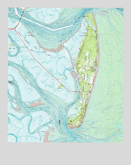
Jekyll Island, GA USGS Topographic Map
Click on map above to begin viewing in our Map Viewer.

This topographic map contains these locations and features:
Feature Name Type Latitude Longitude GNIS ID View Map
Beach CreekStreamN31.0238°W81.4343°310902View Map
Beachside Shopping CenterLocaleN31.0485°W81.4121°2502084View Map
Brunswick PointCapeN31.1102°W81.4548°1671463View Map
Brunswick RiverStreamN31.1202°W81.4265°311914View Map
Cedar CreekChannelN31.0980°W81.4807°312448View Map
Cedar HammockIslandN31.0994°W81.4737°312480View Map
Cherokee CampgroundLocaleN31.1066°W81.4120°1671473View Map
Clam CreekStreamN31.1172°W81.4165°312679View Map
Clam Creek Picnic AreaLocaleN31.1136°W81.4151°1671475View Map
Cobb CreekChannelN31.0775°W81.4698°312784View Map
Dever CutChannelN31.0097°W81.4876°326624View Map
Du Bianons CreekGutN31.1086°W81.4168°355561View Map
DuBignon CemeteryCemeteryN31.1019°W81.4159°1671489View Map
East RiverStreamN31.1222°W81.4912°313783View Map
Faith ChapelChurchN31.0758°W81.4254°1671500View Map
Georgia State Patrol Troop I Post 35 Jekyll IslandBuildingN31.0591°W81.4469°2733968View Map
Indian Mound Golf ClubLocaleN31.0711°W81.4165°1671534View Map
Jekyll Convention CenterBuildingN31.0472°W81.4108°2502592View Map
Jekyll CreekChannelN31.0558°W81.4254°356334View Map
Jekyll HarborHarborN31.0466°W81.4209°2502581View Map
Jekyll IslandIslandN31.0686°W81.4134°356335View Map
Jekyll Island AirportAirportN31.0745°W81.4278°351807View Map
Jekyll Island DivisionCivilN31.0682°W81.4206°2583412View Map
Jekyll Island Fire DepartmentBuildingN31.0632°W81.4205°2603566View Map
Jekyll Island Golf ClubLocaleN31.0712°W81.4165°2502679View Map
Jekyll Island MuseumBuildingN31.0605°W81.4227°2502422View Map
Jekyll Island New Post OfficePost OfficeN31.0586°W81.4195°2502484View Map
Jekyll Island Plaza Shopping CenterLocaleN31.0486°W81.4123°1671538View Map
Jekyll Island State Park AuthorityParkN31.0833°W81.4562°316065View Map
Jekyll Island Water Pollution Control PlantLocaleN31.0438°W81.4210°2502458View Map
Jekyll PointCapeN31.0158°W81.4343°316066View Map
Jekyll SoundBayN31.0252°W81.4443°316067View Map
Jekyll Wharf MarinaHarborN31.0583°W81.4240°2502582View Map
Jointer CreekChannelN31.0577°W81.4748°316199View Map
Latham RiverStreamN31.0686°W81.4345°316661View Map
Little Satilla RiverStreamN31.0366°W81.4520°317191View Map
M E Thompson Memorial BridgeBridgeN31.0475°W81.4243°1671550View Map
Mud RiverChannelN31.0777°W81.4362°319121View Map
Parsons CreekStreamN31.1177°W81.4440°320250View Map
Raccoon Key SpitBarN31.0066°W81.4523°321272View Map
Ruins of Georgias First BreweryLocaleN31.0991°W81.4159°321995View Map
Saint Andrew BeachBeachN31.0177°W81.4215°322042View Map
Saint Andrews Picnic AreaLocaleN31.0208°W81.4329°1671582View Map
Salt Pot CreekStreamN31.0850°W81.4337°322381View Map
Sidney Lanier BridgeBridgeN31.1163°W81.4854°322970View Map
Turtle RiverStreamN31.1169°W81.4915°325777View Map
Umbrella CreekStreamN31.0186°W81.4534°324482View Map
Umbrella CutChannelN31.0272°W81.4787°324483View Map

Note: Coordinates in the location and feature list above are referenced to NAD83 datum.


Copyright (C) 2008-2024 Ryan Niemi / Sunset Dynamics ... All Rights Reserved