TopoQuest Logo
Do you find TopoQuest useful?
Help keep TopoQuest running and adding new maps/features by donating!
Bitcoin:  19c7KJd3qBynnjoSw5npx9KScwjBe4ifkT
Litecoin:  LXs6TkuXGGXo1vDsWCkWVdjQX94eUKd6ui
Home View Maps Find Maps Find Places Resources & Links


Hungry Jack Lake, Minnesota Topographic Map

USGS Map Title: Hungry Jack Lake, MN
USGS Map MRC: 48090A4
DRG (GeoTIFF) Download: o48090a4.tif


Neighboring USGS Topographic Map Quads:


  South Lake, MN  
48090A5
 

  Hungry Jack Lake, MN  
48090A4
 

  Crocodile Lake, MN  
48090A3
 

  Eagle Mountain, MN  
47090H5
 

  Lima Mountain, MN  
47090H4
 

  Pine Mountain, MN  
47090H3


Map MRC Location:

N49°
W91°
N49°
W90°
H8 H7 H6 H5 H4 H3 H2 H1
G8 G7 G6 G5 G4 G3 G2 G1
F8 F7 F6 F5 F4 F3 F2 F1
E8 E7 E6 E5 E4 E3 E2 E1
D8 D7 D6 D5 D4 D3 D2 D1
C8 C7 C6 C5 C4 C3 C2 C1
B8 B7 B6 B5 B4 B3 B2 B1
A8 A7 A6 A5 A4 A3 A2 A1
N48°
W91°
N48°
W90°

Hungry Jack Lake, MN USGS 1:24K Topographic Map Preview:
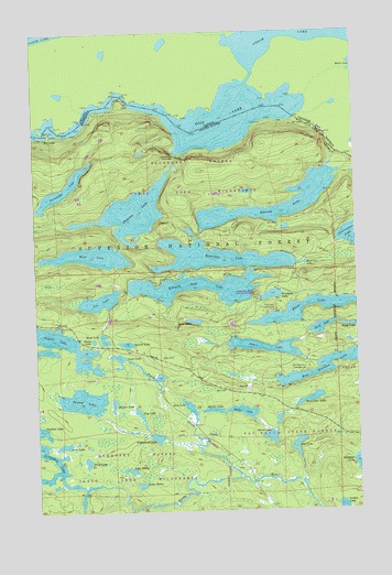
Hungry Jack Lake, MN USGS Topographic Map
Click on map above to begin viewing in our Map Viewer.

This topographic map contains these locations and features:
Feature Name Type Latitude Longitude GNIS ID View Map
Aspen LakeLakeN48.0425°W90.4113°655168View Map
Bear Cub LakeLakeN48.0290°W90.3937°655282View Map
Bearskin LakeLakeN48.0662°W90.4285°655291View Map
Bearskin Lookout TowerTowerN48.0613°W90.3943°659783View Map
Bearskin-Hungry Jack Landing-Parking AccessLocaleN48.0618°W90.4432°659103View Map
Bogenho LakeLakeN48.0644°W90.3955°655468View Map
Bow LakeLakeN48.0268°W90.4407°655491View Map
Daniels LakeLakeN48.0800°W90.3947°655928View Map
Dot LakeLakeN48.0170°W90.3990°656031View Map
Duncan LakeLakeN48.0782°W90.4616°656068View Map
East Bearskin CampgroundLocaleN48.0371°W90.3940°656083View Map
Fag LakeLakeN48.0257°W90.4606°656188View Map
Flour LakeLakeN48.0523°W90.3873°656275View Map
Flour Lake CampgroundLocaleN48.0524°W90.4084°656276View Map
Glenn LakeLakeN48.0192°W90.4096°656386View Map
Gore LakeLakeN48.0174°W90.4900°656417View Map
Gunflint Trail Volunteer Fire Department Station 1BuildingN48.0396°W90.4538°2666659View Map
Honeymoon Bluff Trail and OverlookLocaleN48.0563°W90.4140°659101View Map
Hooker LakeLakeN48.0285°W90.4701°656630View Map
Horseshoe LakeLakeN48.0085°W90.4963°656659View Map
Hungry Jack LakeLakeN48.0583°W90.4360°656680View Map
Hungry Jack Lodge and CampgroundLocaleN48.0611°W90.4508°2072929View Map
Lace LakeLakeN48.0399°W90.4682°656929View Map
Lake HelenLakeN48.0070°W90.4603°656570View Map
Lake MarieLakeN48.0109°W90.4645°657322View Map
Leo LakeLakeN48.0551°W90.4751°656992View Map
Locket LakeLakeN48.0010°W90.3820°657165View Map
Long PortageTrailN48.0960°W90.3862°657201View Map
Moss LakeLakeN48.0668°W90.4779°657491View Map
Nighthawk LakeLakeN48.0193°W90.4539°657599View Map
Okontoe Family CampsitesLocaleN48.0292°W90.4403°2072930View Map
Partridge LakeLakeN48.0844°W90.4889°657747View Map
Pewee LakeLakeN48.0448°W90.4778°657796View Map
Poplar CreekStreamN48.0085°W90.4207°657899View Map
Prop LakeLakeN48.0131°W90.4809°657942View Map
Quiver LakeLakeN48.0263°W90.4316°657960View Map
Rat LakeLakeN48.0984°W90.4981°657985View Map
Road LakeLakeN48.0451°W90.4737°658061View Map
Rose LakeLakeN48.0986°W90.4225°658091View Map
Ruby LakeLakeN48.0479°W90.3762°658112View Map
Rudy LakeLakeN48.0475°W90.3891°658113View Map
Shoko LakeLakeN48.0259°W90.4198°658247View Map
Spen LakeLakeN48.0496°W90.4384°658385View Map
Squint LakeLakeN48.0438°W90.4650°658444View Map
Stairway PortageTrailN48.0924°W90.4451°658449View Map
Swamp LakeLakeN48.0291°W90.4821°658564View Map
Wampus LakeLakeN48.0561°W90.4083°658889View Map

Note: Coordinates in the location and feature list above are referenced to NAD83 datum.


Copyright (C) 2008-2024 Ryan Niemi / Sunset Dynamics ... All Rights Reserved