TopoQuest Logo
Do you find TopoQuest useful?
Help keep TopoQuest running and adding new maps/features by donating!
Bitcoin:  19c7KJd3qBynnjoSw5npx9KScwjBe4ifkT
Litecoin:  LXs6TkuXGGXo1vDsWCkWVdjQX94eUKd6ui
Home View Maps Find Maps Find Places Resources & Links


Forest, Virginia Topographic Map

USGS Map Title: Forest, VA
USGS Map MRC: 37079C3
DRG (GeoTIFF) Download: o37079c3.tif


Neighboring USGS Topographic Map Quads:


  Sedalia, VA  
37079D4
 

  Boonsboro, VA  
37079D3
 

  Lynchburg, VA  
37079D2
 

  Goode, VA  
37079C4
 

  Forest, VA  
37079C3
 

  City Farm, VA  
37079C2
 

  Huddleston, VA  
37079B4
 

  Lynch Station, VA  
37079B3
 

  Castle Craig, VA  
37079B2


Map MRC Location:

N38°
W80°
N38°
W79°
H8 H7 H6 H5 H4 H3 H2 H1
G8 G7 G6 G5 G4 G3 G2 G1
F8 F7 F6 F5 F4 F3 F2 F1
E8 E7 E6 E5 E4 E3 E2 E1
D8 D7 D6 D5 D4 D3 D2 D1
C8 C7 C6 C5 C4 C3 C2 C1
B8 B7 B6 B5 B4 B3 B2 B1
A8 A7 A6 A5 A4 A3 A2 A1
N37°
W80°
N37°
W79°

Forest, VA USGS 1:24K Topographic Map Preview:
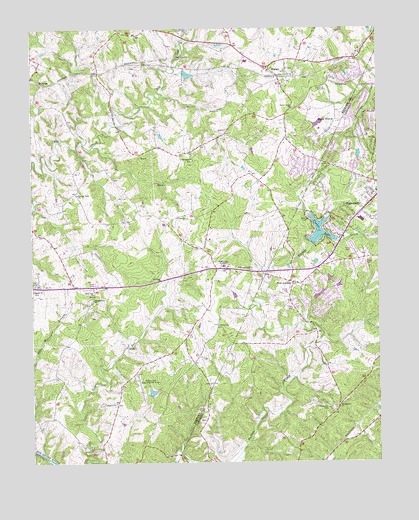
Forest, VA USGS Topographic Map
Click on map above to begin viewing in our Map Viewer.

This topographic map contains these locations and features:
Feature Name Type Latitude Longitude GNIS ID View Map
Academy Presbyterian ChurchChurchN37.3054°W79.3059°1462347View Map
Associated Wheels DamDamN37.2701°W79.3331°1489244View Map
Bedford SpringsPopulated PlaceN37.3057°W79.2720°1674923View Map
BellevuePopulated PlaceN37.3599°W79.3720°1494832View Map
Bethel ChurchChurchN37.2893°W79.3075°1463174View Map
Blue Ridge Montessori SchoolSchoolN37.3623°W79.2877°2498590View Map
Brookville - Timberlake Volunteer Fire DepartmentBuildingN37.3309°W79.2529°2721042View Map
Callaway-Steptoe CemeteryCemeteryN37.3057°W79.2945°1464261View Map
Camp RuthersLocaleN37.3574°W79.2709°1464347View Map
Campbell County Rescue SquadBuildingN37.3330°W79.2507°2075583View Map
Chestnut BranchStreamN37.3371°W79.3742°1482466View Map
Closeburn ManorPopulated PlaceN37.3093°W79.2625°1674934View Map
District 4CivilN37.3718°W79.2997°2750034View Map
Everett School (historical)SchoolN37.3385°W79.3167°1674843View Map
FairfieldsPopulated PlaceN37.2982°W79.2514°1674939View Map
Federal Hill EstatesPopulated PlaceN37.3140°W79.2806°1674940View Map
ForestPopulated PlaceN37.3638°W79.2897°1494932View Map
Forest Census Designated PlaceCensusN37.3727°W79.2828°2389095View Map
Forest Level ChurchChurchN37.3521°W79.2800°1466767View Map
Forest Middle SchoolSchoolN37.3693°W79.3099°2498580View Map
Forest ParkPopulated PlaceN37.3354°W79.2761°1674845View Map
Forest Post OfficePost OfficeN37.3657°W79.2973°2766207View Map
Forest Shopping CenterLocaleN37.3657°W79.2970°1760629View Map
Forest Volunteer Fire Department Company 5BuildingN37.3564°W79.2836°2075582View Map
Homestead HavenPopulated PlaceN37.3629°W79.2575°1674852View Map
Hutter School (historical)SchoolN37.3507°W79.2828°1674855View Map
LandmarkPopulated PlaceN37.3229°W79.2692°1674951View Map
Lebanon ChurchChurchN37.2671°W79.3447°1469246View Map
London Downs Golf CourseLocaleN37.2985°W79.3050°1760630View Map
Meadow WoodPopulated PlaceN37.3585°W79.2911°1674863View Map
Mount Moriah CemeteryCemeteryN37.2660°W79.2686°1470936View Map
Mount Moriah ChurchChurchN37.2663°W79.2647°1470941View Map
Mount Olive ChurchChurchN37.2968°W79.3525°1470966View Map
New LondonPopulated PlaceN37.3018°W79.2803°1471466View Map
New London AcademySchoolN37.3065°W79.3056°1471467View Map
New London AirportAirportN37.2737°W79.3372°1491206View Map
Nottingham ForestPopulated PlaceN37.3354°W79.2581°1674966View Map
Oak Mountain School (historical)SchoolN37.2968°W79.3528°1674880View Map
OakviewPopulated PlaceN37.3613°W79.2622°1674882View Map
Old Elkton LakeReservoirN37.3618°W79.3181°1489237View Map
Old Elkton Lake DamDamN37.3618°W79.3197°1489236View Map
Penn ForestPopulated PlaceN37.3457°W79.2553°1674970View Map
Pisgah ChurchChurchN37.2996°W79.3745°1472442View Map
Poplar ForestPopulated PlaceN37.3485°W79.2645°1495098View Map
Poplar Forest DamDamN37.3485°W79.2697°1489238View Map
Poplar Forest Golf CourseLocaleN37.3474°W79.2678°1760631View Map
Poplar Forest LakeReservoirN37.3476°W79.2710°1489239View Map
Rainbow ForestPopulated PlaceN37.3507°W79.2586°1674972View Map
Rock Pike ChurchChurchN37.2988°W79.3525°1473382View Map
Saint Johns ChurchChurchN37.3026°W79.3284°1473769View Map
Saint Pauls ChurchChurchN37.3368°W79.3159°1473880View Map
Sandy AcresPopulated PlaceN37.3001°W79.2742°1674976View Map
Sleepy HollowPopulated PlaceN37.3371°W79.2545°1674979View Map
TanglewoodPopulated PlaceN37.2954°W79.2761°1674982View Map
Terrace View ChurchChurchN37.3274°W79.3581°1475539View Map
Thomas Jefferson Elementary SchoolSchoolN37.3566°W79.2882°2498650View Map
Timber LakeReservoirN37.3163°W79.2709°1502143View Map
Timber Lake DamDamN37.3132°W79.2734°1489307View Map
TimberlakePopulated PlaceN37.3207°W79.2575°1495150View Map
Timberlake Airport (historical)AirportN37.3335°W79.2664°1498722View Map
Timberlake Christian SchoolSchoolN37.3394°W79.2598°2498603View Map
Timberlake DistrictCivilN37.3277°W79.2633°1927537View Map
Westward ParkPopulated PlaceN37.3479°W79.2520°1674991View Map
WildwoodPopulated PlaceN37.2971°W79.2684°1674994View Map
Wildwood Dam Number OneDamN37.3301°W79.2697°1489315View Map
Wildwood Dam Number ThreeDamN37.3018°W79.2647°1489325View Map
Wildwood Dam Number TwoDamN37.3018°W79.2664°1489326View Map
Wildwood LakeReservoirN37.3301°W79.2697°1489316View Map
Windcrest ManorPopulated PlaceN37.3279°W79.2692°1674995View Map
WoodlandsPopulated PlaceN37.3451°W79.2939°1674916View Map

Note: Coordinates in the location and feature list above are referenced to NAD83 datum.


Copyright (C) 2008-2024 Ryan Niemi / Sunset Dynamics ... All Rights Reserved