TopoQuest Logo
Do you find TopoQuest useful?
Help keep TopoQuest running and adding new maps/features by donating!
Bitcoin:  19c7KJd3qBynnjoSw5npx9KScwjBe4ifkT
Litecoin:  LXs6TkuXGGXo1vDsWCkWVdjQX94eUKd6ui
Home View Maps Find Maps Find Places Resources & Links


Evansville, Arkansas Topographic Map

USGS Map Title: Evansville, AR
USGS Map MRC: 35094G4
DRG (GeoTIFF) Download: o35094g4.tif


Neighboring USGS Topographic Map Quads:


  Westville, OK  
35094H5
 

  Lincoln, AR  
35094H4
 

  Prairie Grove, AR  
35094H3
 

  Stilwell East, OK  
35094G5
 

  Evansville, AR  
35094G4
 

  Strickler, AR  
35094G3
 

  Big Round Mountain, OK  
35094F5
 

  Natural Dam, AR  
35094F4
 

  Rudy NE, AR  
35094F3


Map MRC Location:

N36°
W95°
N36°
W94°
H8 H7 H6 H5 H4 H3 H2 H1
G8 G7 G6 G5 G4 G3 G2 G1
F8 F7 F6 F5 F4 F3 F2 F1
E8 E7 E6 E5 E4 E3 E2 E1
D8 D7 D6 D5 D4 D3 D2 D1
C8 C7 C6 C5 C4 C3 C2 C1
B8 B7 B6 B5 B4 B3 B2 B1
A8 A7 A6 A5 A4 A3 A2 A1
N35°
W95°
N35°
W94°

Evansville, AR USGS 1:24K Topographic Map Preview:
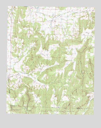
Evansville, AR USGS Topographic Map
Click on map above to begin viewing in our Map Viewer.

This topographic map contains these locations and features:
Feature Name Type Latitude Longitude GNIS ID View Map
Academy CemeteryCemeteryN35.7956°W94.4833°70406View Map
Anderson MountainSummitN35.8095°W94.4633°76172View Map
Antioch ChurchChurchN35.8129°W94.4080°70453View Map
Apostolic ChurchChurchN35.8684°W94.4035°70457View Map
Ashley HollowValleyN35.7829°W94.4449°70472View Map
Bethlehem CemeteryCemeteryN35.8681°W94.4594°77339View Map
Cox CemeteryCemeteryN35.8659°W94.3991°71271View Map
Dobbs CemeteryCemeteryN35.7642°W94.4213°71393View Map
Dunagan CemeteryCemeteryN35.8026°W94.4502°71468View Map
Edmiston CemeteryCemeteryN35.8606°W94.4238°71534View Map
English CemeteryCemeteryN35.8662°W94.4474°71562View Map
EvansvillePopulated PlaceN35.7954°W94.4969°76889View Map
Evansville Fire DepartmentBuildingN35.8016°W94.4962°2116414View Map
Evansville Post OfficePost OfficeN35.7934°W94.4977°84304View Map
Fly CreekStreamN35.8740°W94.4574°71644View Map
Fly Creek ChurchChurchN35.8701°W94.3874°71645View Map
Garrett Creek CemeteryCemeteryN35.7712°W94.3794°71734View Map
Garrett HollowValleyN35.7767°W94.3752°71735View Map
Goddard CemeteryCemeteryN35.7987°W94.4638°71778View Map
Grapevine RidgeRidgeN35.7573°W94.4499°71807View Map
Hale MountainSummitN35.8201°W94.4508°71875View Map
Hale Mountain ChurchChurchN35.8237°W94.4422°71876View Map
Hennman SpringSpringN35.7537°W94.4708°74385View Map
Lewis CemeteryCemeteryN35.7929°W94.4877°72312View Map
Low Gap HollowValleyN35.7731°W94.4719°81341View Map
Low HollowValleyN35.7956°W94.3752°72508View Map
MorrowPopulated PlaceN35.8584°W94.4374°72735View Map
Morrow Post OfficePost OfficeN35.8587°W94.4369°84313View Map
Morrow Volunteer Fire DepartmentBuildingN35.8596°W94.4361°2116818View Map
Mount Pleasant ChurchChurchN35.8526°W94.4283°72766View Map
New Center Point ChurchChurchN35.7929°W94.4691°72851View Map
OdellPopulated PlaceN35.7726°W94.4183°72919View Map
SkylightPopulated PlaceN35.8423°W94.3944°73599View Map
Skylight MountainSummitN35.8337°W94.3752°73600View Map
Stop (historical)Populated PlaceN35.7520°W94.4113°66233View Map
ToluPopulated PlaceN35.8145°W94.4952°78565View Map
Tolu Post Office (historical)Post OfficeN35.8145°W94.4952°84322View Map
Township of BostonCivilN35.8064°W94.4054°69779View Map
Township of MorrowCivilN35.8661°W94.4427°69796View Map
Township of VineyardCivilN35.8000°W94.4740°69807View Map
Vineyard ChurchChurchN35.8167°W94.4827°73972View Map

Note: Coordinates in the location and feature list above are referenced to NAD83 datum.


Copyright (C) 2008-2024 Ryan Niemi / Sunset Dynamics ... All Rights Reserved