TopoQuest Logo
Do you find TopoQuest useful?
Help keep TopoQuest running and adding new maps/features by donating!
Bitcoin:  19c7KJd3qBynnjoSw5npx9KScwjBe4ifkT
Litecoin:  LXs6TkuXGGXo1vDsWCkWVdjQX94eUKd6ui
Home View Maps Find Maps Find Places Resources & Links


Canaan, Maine Topographic Map

USGS Map Title: Canaan, ME
USGS Map MRC: 44069G5
DRG (GeoTIFF) Download: o44069g5.tif


Neighboring USGS Topographic Map Quads:


  Athens, ME  
44069H6
 

  Harmony, ME  
44069H5
 

  Hartland, ME  
44069H4
 

  Skowhegan, ME  
44069G6
 

  Canaan, ME  
44069G5
 

  Pittsfield, ME  
44069G4
 

  Hinckley, ME  
44069F6
 

  Clinton, ME  
44069F5
 

  Burnham, ME  
44069F4


Map MRC Location:

N45°
W70°
N45°
W69°
H8 H7 H6 H5 H4 H3 H2 H1
G8 G7 G6 G5 G4 G3 G2 G1
F8 F7 F6 F5 F4 F3 F2 F1
E8 E7 E6 E5 E4 E3 E2 E1
D8 D7 D6 D5 D4 D3 D2 D1
C8 C7 C6 C5 C4 C3 C2 C1
B8 B7 B6 B5 B4 B3 B2 B1
A8 A7 A6 A5 A4 A3 A2 A1
N44°
W70°
N44°
W69°

Canaan, ME USGS 1:24K Topographic Map Preview:
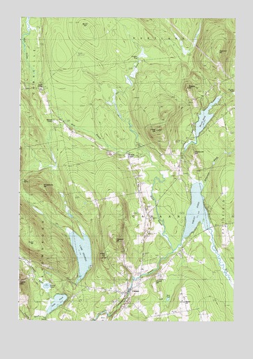
Canaan, ME USGS Topographic Map
Click on map above to begin viewing in our Map Viewer.

This topographic map contains these locations and features:
Feature Name Type Latitude Longitude GNIS ID View Map
Black StreamStreamN44.7787°W69.5350°562512View Map
Browns CornerPopulated PlaceN44.8192°W69.5628°579158View Map
Burrill HillSummitN44.8706°W69.5873°563279View Map
Camp Modin for BoysLocaleN44.7720°W69.5837°563404View Map
Camp Modin for GirlsLocaleN44.7681°W69.5903°563405View Map
CanaanPopulated PlaceN44.7617°W69.5614°563445View Map
Canaan BogSwampN44.7748°W69.5098°563447View Map
Canaan Elementary SchoolSchoolN44.7634°W69.5714°1908502View Map
Canaan Fire DepartmentBuildingN44.7615°W69.5625°2553045View Map
Canaan Post OfficePost OfficeN44.7617°W69.5619°1908504View Map
Canaan Public LibraryBuildingN44.7626°W69.5608°2738394View Map
Canaan Volunteer Fire DepartmentBuildingN44.7617°W69.5618°2553087View Map
Chase HillSummitN44.8292°W69.5451°563878View Map
Church HillSummitN44.7670°W69.5461°563984View Map
Comeouter HillSummitN44.8193°W69.5241°564257View Map
Cooper BrookStreamN44.7887°W69.5139°564343View Map
East Branch Black StreamStreamN44.8176°W69.5492°565533View Map
Fairview CemeteryCemeteryN44.7695°W69.5548°566007View Map
Goodwin HillSummitN44.7828°W69.5692°566898View Map
Goodwin HillSummitN44.8612°W69.5103°566899View Map
Gould CornerPopulated PlaceN44.8464°W69.6106°579349View Map
Jewell HillSummitN44.7762°W69.5757°568819View Map
Juniper BogSwampN44.8592°W69.5495°569026View Map
Lake GeorgeLakeN44.7780°W69.5883°566744View Map
Lambert BrookStreamN44.7590°W69.6048°569339View Map
Mitchell CornerPopulated PlaceN44.8323°W69.6053°579527View Map
Morrill PondLakeN44.8339°W69.5176°571675View Map
Mud PondLakeN44.7590°W69.5384°571901View Map
Nelson HillSummitN44.7573°W69.5298°572091View Map
Nevins CemeteryCemeteryN44.8434°W69.5171°572107View Map
Oaks PondLakeN44.7575°W69.6025°572654View Map
Richards CemeteryCemeteryN44.8445°W69.6100°574166View Map
Round PondLakeN44.7644°W69.6085°574508View Map
Sibley PondLakeN44.7955°W69.5222°575448View Map
Slab City CemeteryCemeteryN44.8199°W69.5369°575538View Map
Stafford BrookStreamN44.7509°W69.6087°576219View Map
The NotchGapN44.8078°W69.6223°576874View Map
Tibbetts HillSummitN44.8468°W69.5281°577092View Map
Town of CanaanCivilN44.7793°W69.5497°582385View Map
Union ChurchChurchN44.7634°W69.5589°577549View Map
West Branch Black StreamStreamN44.8176°W69.5489°578038View Map
Whitcombe BrookStreamN44.8059°W69.5184°578337View Map
Whittemore HillSummitN44.8044°W69.6117°578426View Map
Wilson CemeteryCemeteryN44.7884°W69.5034°2737048View Map

Note: Coordinates in the location and feature list above are referenced to NAD83 datum.


Copyright (C) 2008-2024 Ryan Niemi / Sunset Dynamics ... All Rights Reserved