TopoQuest Logo
Do you find TopoQuest useful?
Help keep TopoQuest running and adding new maps/features by donating!
Bitcoin:  19c7KJd3qBynnjoSw5npx9KScwjBe4ifkT
Litecoin:  LXs6TkuXGGXo1vDsWCkWVdjQX94eUKd6ui
Home View Maps Find Maps Find Places Resources & Links


Dayton North, Wyoming Topographic Map

USGS Map Title: Dayton North, WY
USGS Map MRC: 44107H3
DRG (GeoTIFF) Download: o44107h3.tif


Neighboring USGS Topographic Map Quads:


  Pass Creek West, MT  
45107A4
 

  Pass Creek East, MT  
45107A3
 

  Little Bear Creek, MT  
45107A2
 

  Columbus Peak, WY  
44107H4
 

  Dayton North, WY  
44107H3
 

  Ranchester, WY  
44107H2
 

  Skull Ridge, WY  
44107G4
 

  Dayton South, WY  
44107G3
 

  Wolf, WY  
44107G2


Map MRC Location:

N45°
W108°
N45°
W107°
H8 H7 H6 H5 H4 H3 H2 H1
G8 G7 G6 G5 G4 G3 G2 G1
F8 F7 F6 F5 F4 F3 F2 F1
E8 E7 E6 E5 E4 E3 E2 E1
D8 D7 D6 D5 D4 D3 D2 D1
C8 C7 C6 C5 C4 C3 C2 C1
B8 B7 B6 B5 B4 B3 B2 B1
A8 A7 A6 A5 A4 A3 A2 A1
N44°
W108°
N44°
W107°

Dayton North, WY USGS 1:24K Topographic Map Preview:
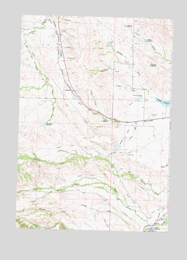
Dayton North, WY USGS Topographic Map
Click on map above to begin viewing in our Map Viewer.

This topographic map contains these locations and features:
Feature Name Type Latitude Longitude GNIS ID View Map
Antwerp DamDamN44.9150°W107.2923°1606780View Map
Antwerp ReservoirReservoirN44.9949°W107.2892°1584906View Map
Antwerp ReservoirReservoirN44.9150°W107.2923°1606781View Map
Ashenbach DamDamN44.9200°W107.2973°1606790View Map
Ashenbach ReservoirReservoirN44.9200°W107.2973°1606791View Map
Barker ReservoirReservoirN44.9870°W107.2724°1585125View Map
Bear Claw Love Number 1 DamDamN44.9033°W107.3340°1606814View Map
Bear Claw Love Number 1 ReservoirReservoirN44.9038°W107.3365°1606815View Map
Bear Claw RanchLocaleN44.9022°W107.3276°1585243View Map
Bonanza CreekStreamN44.9675°W107.2779°1585763View Map
Brand Point DitchCanalN44.9211°W107.2867°1585882View Map
Cooper DamDamN44.9516°W107.2790°1606876View Map
Cooper DrawValleyN44.9580°W107.2723°1586962View Map
Cooper ReservoirReservoirN44.9519°W107.2773°1606877View Map
Currant DrawValleyN44.8755°W107.2745°1587296View Map
DaytonPopulated PlaceN44.8752°W107.2623°1587386View Map
Dayton Post OfficePost OfficeN44.8764°W107.2632°2765624View Map
Dry Twin CreekStreamN44.9608°W107.3523°1587879View Map
East Twin CreekStreamN44.9789°W107.3698°1609247View Map
Fivemile DitchCanalN44.9225°W107.3162°1588542View Map
Fivemile ReservoirReservoirN44.9511°W107.2565°1588550View Map
Gannon DrawValleyN45.0000°W107.3512°1588792View Map
Grande GulchValleyN44.9886°W107.3440°1589028View Map
Grouse DrawValleyN44.9441°W107.3093°1589173View Map
Huntington DamDamN44.9366°W107.3506°1606778View Map
Huntington ReservoirReservoirN44.9362°W107.3533°1589821View Map
Little Tongue RiverStreamN44.8780°W107.2634°1601052View Map
Magpie GulchValleyN44.8980°W107.3440°1591171View Map
Mock Bass DamDamN44.8800°W107.3106°1606816View Map
Mock Bass ReservoirReservoirN44.8800°W107.3106°1606817View Map
Mock DitchCanalN44.9108°W107.2806°1591672View Map
Mock Ditch Number 2CanalN44.8900°W107.2970°1605383View Map
Owen Brothers DamDamN44.9666°W107.3056°1606616View Map
Owen Brothers ReservoirReservoirN44.9666°W107.3056°1606617View Map
Owens DitchCanalN44.9072°W107.3184°1592514View Map
Padlock Number 1 A Five Mile DamDamN44.9483°W107.2556°1606784View Map
Padlock Number 1 A Five Mile ReservoirReservoirN44.9483°W107.2556°1606785View Map
Padlock RanchLocaleN44.8827°W107.2520°1592543View Map
ParkmanLocaleN44.9569°W107.3326°1597454View Map
ParkmanPopulated PlaceN44.9569°W107.3326°1805262View Map
Parkman Census Designated PlaceCensusN44.9488°W107.3077°2409032View Map
Parkman Post OfficePost OfficeN44.9571°W107.3325°2767882View Map
Slack SchoolSchoolN44.9569°W107.3326°1795611View Map
Smith CreekStreamN44.8780°W107.2681°1602994View Map
South Fork Fivemile CreekStreamN44.9536°W107.2659°1594648View Map
Steele ReservoirReservoirN44.9396°W107.3009°1595024View Map
Tongue River Ditch Number 1CanalN44.8875°W107.2592°1605495View Map
Tongue River High SchoolSchoolN44.8752°W107.2623°1795609View Map
Underwood Reservoir Number 2ReservoirN44.9721°W107.2680°1605508View Map
Wagner DamDamN44.9250°W107.2940°1608388View Map
Wagner DrawValleyN44.9255°W107.2906°1595964View Map
Wagner ReservoirReservoirN44.9242°W107.2936°1608389View Map

Note: Coordinates in the location and feature list above are referenced to NAD83 datum.


Copyright (C) 2008-2024 Ryan Niemi / Sunset Dynamics ... All Rights Reserved