TopoQuest Logo
Do you find TopoQuest useful?
Help keep TopoQuest running and adding new maps/features by donating!
Bitcoin:  19c7KJd3qBynnjoSw5npx9KScwjBe4ifkT
Litecoin:  LXs6TkuXGGXo1vDsWCkWVdjQX94eUKd6ui
Home View Maps Find Maps Find Places Resources & Links


Cedar Gap, Missouri Topographic Map

USGS Map Title: Cedar Gap, MO
USGS Map MRC: 37092A6
DRG (GeoTIFF) Download: o37092a6.tif


Neighboring USGS Topographic Map Quads:


  Seymour, MO  
37092B7
 

  Mansfield NW, MO  
37092B6
 

  Mansfield NE, MO  
37092B5
 

  Dogwood, MO  
37092A7
 

  Cedar Gap, MO  
37092A6
 

  Mansfield, MO  
37092A5
 

  Goodhope, MO  
36092H7
 

  Ava, MO  
36092H6
 

  Sweden, MO  
36092H5


Map MRC Location:

N38°
W93°
N38°
W92°
H8 H7 H6 H5 H4 H3 H2 H1
G8 G7 G6 G5 G4 G3 G2 G1
F8 F7 F6 F5 F4 F3 F2 F1
E8 E7 E6 E5 E4 E3 E2 E1
D8 D7 D6 D5 D4 D3 D2 D1
C8 C7 C6 C5 C4 C3 C2 C1
B8 B7 B6 B5 B4 B3 B2 B1
A8 A7 A6 A5 A4 A3 A2 A1
N37°
W93°
N37°
W92°

Cedar Gap, MO USGS 1:24K Topographic Map Preview:
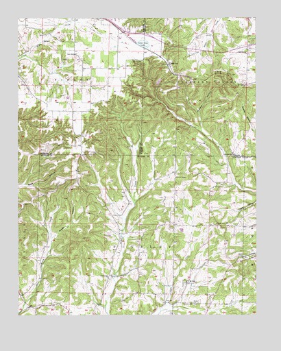
Cedar Gap, MO USGS Topographic Map
Click on map above to begin viewing in our Map Viewer.

This topographic map contains these locations and features:
Feature Name Type Latitude Longitude GNIS ID View Map
Ava Rural Fire Department Station 1BuildingN37.0080°W92.6646°2621678View Map
Bragg HollowValleyN37.0334°W92.7310°714625View Map
Brush Arbor ChurchChurchN37.0384°W92.6460°714817View Map
Cedar GapPopulated PlaceN37.1056°W92.6696°715592View Map
Cedar Gap CemeteryCemeteryN37.1071°W92.6848°715593View Map
Cedar Gap DamDamN37.1134°W92.6852°763781View Map
Cedar Gap LakeReservoirN37.1134°W92.6852°758261View Map
Cedar Gap School (historical)SchoolN37.1053°W92.6699°735066View Map
Day ChurchChurchN37.0762°W92.7163°716754View Map
Denney CemeteryCemeteryN37.0162°W92.7013°718385View Map
Farthing East DamDamN37.0917°W92.7252°765399View Map
Farthing West DamDamN37.0934°W92.7318°765400View Map
Flint Point School (historical)SchoolN37.0506°W92.6493°733857View Map
Gentry Church (historical)ChurchN37.0168°W92.7014°2612057View Map
Gentry SchoolSchoolN37.0164°W92.7032°718388View Map
Glad Hill ChurchChurchN37.0670°W92.6377°718477View Map
GranadaPopulated PlaceN37.0278°W92.7366°733858View Map
Granada School (historical)SchoolN37.0264°W92.7366°733856View Map
Hershell Letsinger LakeReservoirN37.0351°W92.6635°763754View Map
Huffman CemeteryCemeteryN37.0045°W92.6585°719962View Map
Lead HillSummitN37.1012°W92.6374°720861View Map
Lead Hill ChurchChurchN37.1106°W92.6299°720863View Map
Letsinger Lake DamDamN37.0351°W92.6635°763753View Map
Mount ZionPopulated PlaceN37.0134°W92.6610°722923View Map
Mount Zion CemeteryCemeteryN37.0053°W92.6585°722927View Map
Mountain Side SchoolSchoolN37.0578°W92.6674°735738View Map
Panther HollowValleyN37.0848°W92.6543°723997View Map
Rush CemeteryCemeteryN37.1098°W92.7202°725668View Map
Sky Light School (historical)SchoolN37.0498°W92.7088°733855View Map
Township of FindleyCivilN37.0233°W92.6867°766623View Map
ZendaPopulated PlaceN37.0176°W92.6938°740326View Map

Note: Coordinates in the location and feature list above are referenced to NAD83 datum.


Copyright (C) 2008-2024 Ryan Niemi / Sunset Dynamics ... All Rights Reserved