TopoQuest Logo
Do you find TopoQuest useful?
Help keep TopoQuest running and adding new maps/features by donating!
Bitcoin:  19c7KJd3qBynnjoSw5npx9KScwjBe4ifkT
Litecoin:  LXs6TkuXGGXo1vDsWCkWVdjQX94eUKd6ui
Home View Maps Find Maps Find Places Resources & Links


Birch Point, Washington Topographic Map

USGS Map Title: Birch Point, WA
USGS Map MRC: 48122H7
DRG (GeoTIFF) Download: o48122h7.tif


Neighboring USGS Topographic Map Quads:


  Birch Point, WA  
48122H7
 

  Blaine, WA  
48122H6
 

  Sucia Island, WA  
48122G8


  Lummi Bay, WA  
48122G6


Map MRC Location:

N49°
W123°
N49°
W122°
H8 H7 H6 H5 H4 H3 H2 H1
G8 G7 G6 G5 G4 G3 G2 G1
F8 F7 F6 F5 F4 F3 F2 F1
E8 E7 E6 E5 E4 E3 E2 E1
D8 D7 D6 D5 D4 D3 D2 D1
C8 C7 C6 C5 C4 C3 C2 C1
B8 B7 B6 B5 B4 B3 B2 B1
A8 A7 A6 A5 A4 A3 A2 A1
N48°
W123°
N48°
W122°

Birch Point, WA USGS 1:24K Topographic Map Preview:
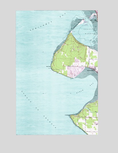
Birch Point, WA USGS Topographic Map
Click on map above to begin viewing in our Map Viewer.

This topographic map contains these locations and features:
Feature Name Type Latitude Longitude GNIS ID View Map
Birch BayBayN48.9218°W122.7696°1503380View Map
Birch Bay Census Designated PlaceCensusN48.8900°W122.7634°2407850View Map
Birch Bay Sewage Treatment PlantLocaleN48.8990°W122.7695°2610646View Map
Birch Bay State ParkParkN48.9032°W122.7649°1531408View Map
Birch Bay Village Golf CourseLocaleN48.9405°W122.7814°2608376View Map
Birch Bay Village MarinaLocaleN48.9354°W122.7865°2610333View Map
Birch PointCapeN48.9434°W122.8221°1503383View Map
Blaine DivisionCivilN48.9387°W122.7688°1939452View Map
Blaine Visitors CenterBuildingN48.9938°W122.7511°2610498View Map
Blaine Wastewater Treatment PlantLocaleN48.9775°W122.7924°2610625View Map
Cottonwood BeachPopulated PlaceN48.9398°W122.7571°1512116View Map
Drayton HarborBayN48.9750°W122.7583°1514723View Map
North Bay Mobile Home ParkPopulated PlaceN48.9393°W122.7525°2607106View Map
North Whatcom Fire Rescue Station 62 SemiahmooBuildingN48.9695°W122.7917°2619334View Map
Point WhitehornCapeN48.8946°W122.7930°1507542View Map
Port of BlaineLocaleN48.9940°W122.7596°1514347View Map
SemiahmooPopulated PlaceN48.9890°W122.7732°1511302View Map
Semiahmoo BayBayN48.9998°W122.8180°1508217View Map
Semiahmoo Golf and Country ClubLocaleN48.9619°W122.7805°2608193View Map
Semiahmoo MarinaLocaleN48.9881°W122.7702°2610390View Map
Semiahmoo Park Maritime MuseumBuildingN48.9789°W122.7913°2610428View Map
Semiahmoo SpitCapeN48.9846°W122.7816°1508218View Map
Semiahmoo SpitBarN48.9851°W122.7830°1534456View Map
Semiahmoo Yacht ClubLocaleN48.9904°W122.7733°2610391View Map
Terrell CreekStreamN48.9023°W122.7710°1508953View Map
Tongue PointCapeN48.9912°W122.7721°1531527View Map
Unruh ReservoirReservoirN48.8947°W122.7533°1532134View Map
Unruh Reservoir DamDamN48.8965°W122.7530°1532133View Map
Whatcom County Fire District 7 Station 44 - Birch BayBuildingN48.8923°W122.7812°2643586View Map

Note: Coordinates in the location and feature list above are referenced to NAD83 datum.


Copyright (C) 2008-2024 Ryan Niemi / Sunset Dynamics ... All Rights Reserved