TopoQuest Logo
Do you find TopoQuest useful?
Help keep TopoQuest running and adding new maps/features by donating!
Bitcoin:  19c7KJd3qBynnjoSw5npx9KScwjBe4ifkT
Litecoin:  LXs6TkuXGGXo1vDsWCkWVdjQX94eUKd6ui
Home View Maps Find Maps Find Places Resources & Links


Camp Hill, Alabama Topographic Map

USGS Map Title: Camp Hill, AL
USGS Map MRC: 32085G6
DRG (GeoTIFF) Download: o32085g6.tif


Neighboring USGS Topographic Map Quads:


  Jacksons Gap, AL  
32085H7
 

  Buttston, AL  
32085H6
 

  Dudleyville, AL  
32085H5
 

  Dadeville, AL  
32085G7
 

  Camp Hill, AL  
32085G6
 

  Camp Hill SE, AL  
32085G5
 

  Ponders, AL  
32085F7
 

  Thornton, AL  
32085F6
 

  Waverly, AL  
32085F5


Map MRC Location:

N33°
W86°
N33°
W85°
H8 H7 H6 H5 H4 H3 H2 H1
G8 G7 G6 G5 G4 G3 G2 G1
F8 F7 F6 F5 F4 F3 F2 F1
E8 E7 E6 E5 E4 E3 E2 E1
D8 D7 D6 D5 D4 D3 D2 D1
C8 C7 C6 C5 C4 C3 C2 C1
B8 B7 B6 B5 B4 B3 B2 B1
A8 A7 A6 A5 A4 A3 A2 A1
N32°
W86°
N32°
W85°

Camp Hill, AL USGS 1:24K Topographic Map Preview:
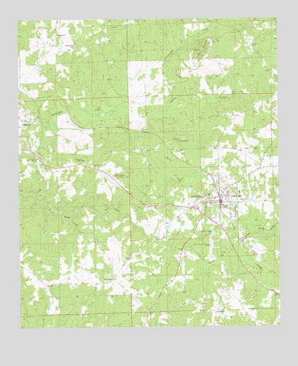
Camp Hill, AL USGS Topographic Map
Click on map above to begin viewing in our Map Viewer.

This topographic map contains these locations and features:
Feature Name Type Latitude Longitude GNIS ID View Map
AgricolaPopulated PlaceN32.7685°W85.7386°155980View Map
Andrews BranchStreamN32.8382°W85.7052°113080View Map
Baskins ChapelChurchN32.8646°W85.7230°113551View Map
Beulah Number 2 ChurchChurchN32.8151°W85.7138°114194View Map
Bradshaw DamDamN32.7635°W85.7233°131008View Map
Bradshaw LakeReservoirN32.7635°W85.7233°131007View Map
Camp HillPopulated PlaceN32.8004°W85.6536°115465View Map
Camp Hill Baptist ChurchChurchN32.8029°W85.6522°137380View Map
Camp Hill DivisionCivilN32.7766°W85.6493°165967View Map
Camp Hill High School (historical)SchoolN32.8043°W85.6438°158682View Map
Camp Hill Post OfficePost OfficeN32.7981°W85.6539°167981View Map
Camp Hill ReservoirReservoirN32.8020°W85.6379°131027View Map
Camp Hill Reservoir DamDamN32.8018°W85.6366°131026View Map
Camp Hill Volunteer Fire DepartmentBuildingN32.8003°W85.6532°2691519View Map
Camp Hill-Tallapoosa County Airport (historical)AirportN32.7821°W85.6583°129444View Map
Civilian Conservation Corps Camp Number 1405 (historical)LocaleN32.8085°W85.7247°157688View Map
Collum MineMineN32.8746°W85.7033°157689View Map
Doss MountainSummitN32.8626°W85.6616°117391View Map
Edward Bell High SchoolSchoolN32.7987°W85.6508°158991View Map
Farington DamDamN32.8251°W85.7466°131036View Map
Farington LakeReservoirN32.8251°W85.7466°131035View Map
First Methodist Episcopal ChurchChurchN32.8024°W85.6522°137424View Map
First Universalist ChurchChurchN32.8024°W85.6525°137426View Map
Holley CemeteryCemeteryN32.7779°W85.6972°120246View Map
Lake Martin Community HospitalHospitalN32.8187°W85.7409°117789View Map
Langley CemeteryCemeteryN32.8640°W85.6377°121387View Map
Little Sandy CreekStreamN32.7821°W85.6455°121881View Map
Lyman Ward Military AcademySchoolN32.8029°W85.6605°152176View Map
MaryPopulated PlaceN32.7557°W85.6886°156664View Map
Morgan CemeteryCemeteryN32.8298°W85.6888°137478View Map
Mount Carmel ChurchChurchN32.8690°W85.7313°123174View Map
Mount Carmel School (historical)SchoolN32.8693°W85.7308°157695View Map
New Poplar Springs ChurchChurchN32.7662°W85.7380°137484View Map
North Fork Sandy CreekStreamN32.7921°W85.6941°137487View Map
Pine GrovePopulated PlaceN32.7699°W85.7050°156892View Map
Pine Grove ChurchChurchN32.7679°W85.7266°137499View Map
Pinkston ProspectsMineN32.8537°W85.7355°157698View Map
PinnellPopulated PlaceN32.7560°W85.6552°124903View Map
SlaughtersPopulated PlaceN32.8254°W85.6725°157073View Map
Slaughters CemeteryCemeteryN32.8362°W85.6500°137529View Map
Spring Hill CemeteryCemeteryN32.8257°W85.6733°127239View Map
Tallapoosa AcademySchoolN32.8179°W85.7191°127642View Map
Tallapoosa County Memorial GardensCemeteryN32.8121°W85.7055°127643View Map
Town of Camp HillCivilN32.8002°W85.6537°2405370View Map

Note: Coordinates in the location and feature list above are referenced to NAD83 datum.


Copyright (C) 2008-2024 Ryan Niemi / Sunset Dynamics ... All Rights Reserved