TopoQuest Logo
Do you find TopoQuest useful?
Help keep TopoQuest running and adding new maps/features by donating!
Bitcoin:  19c7KJd3qBynnjoSw5npx9KScwjBe4ifkT
Litecoin:  LXs6TkuXGGXo1vDsWCkWVdjQX94eUKd6ui
Home View Maps Find Maps Find Places Resources & Links


Barton, Maryland Topographic Map

USGS Map Title: Barton, MD
USGS Map MRC: 39079E1
DRG (GeoTIFF) Download: o39079e1.tif


Neighboring USGS Topographic Map Quads:


  Grantsville, MD  
39079F2
 

  Avilton, MD  
39079F1
 

  Frostburg, MD  
39078F8
 

  Bittinger, MD  
39079E2
 

  Barton, MD  
39079E1
 

  Lonaconing, MD  
39078E8
 

  Kitzmiller, MD  
39079D2
 

  Westernport, MD  
39079D1
 

  Keyser, WV  
39078D8


Map MRC Location:

N40°
W80°
N40°
W79°
H8 H7 H6 H5 H4 H3 H2 H1
G8 G7 G6 G5 G4 G3 G2 G1
F8 F7 F6 F5 F4 F3 F2 F1
E8 E7 E6 E5 E4 E3 E2 E1
D8 D7 D6 D5 D4 D3 D2 D1
C8 C7 C6 C5 C4 C3 C2 C1
B8 B7 B6 B5 B4 B3 B2 B1
A8 A7 A6 A5 A4 A3 A2 A1
N39°
W80°
N39°
W79°

Barton, MD USGS 1:24K Topographic Map Preview:
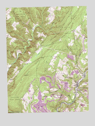
Barton, MD USGS Topographic Map
Click on map above to begin viewing in our Map Viewer.

This topographic map contains these locations and features:
Feature Name Type Latitude Longitude GNIS ID View Map
Barlett CemeteryCemeteryN39.5462°W79.0134°583026View Map
Bartlett HillSummitN39.5409°W79.0186°589699View Map
BartonPopulated PlaceN39.5306°W79.0175°583047View Map
Barton Debris BasinReservoirN39.5417°W79.0338°594361View Map
Barton Debris Basin DamDamN39.5418°W79.0331°594360View Map
Barton Elementary SchoolSchoolN39.5201°W79.0175°1713380View Map
Barton HillSummitN39.5245°W79.0064°589700View Map
Barton Hose Company 1BuildingN39.5305°W79.0163°2085794View Map
Barton Police DepartmentBuildingN39.5315°W79.0166°2780854View Map
Barton Post OfficePost OfficeN39.5299°W79.0180°1713381View Map
Barton ReservationReserveN39.5409°W79.0314°583048View Map
Bear HillSummitN39.6018°W79.0434°589715View Map
Bear Pen RunStreamN39.5620°W79.1103°583092View Map
Big Savage MountainSummitN39.5443°W79.0961°589754View Map
Blacklick RunStreamN39.6018°W79.0773°583272View Map
Bluelick RunStreamN39.6020°W79.0709°583304View Map
Broadwater ChapelChurchN39.5648°W79.1086°583419View Map
Butcher RunStreamN39.5343°W79.0153°583508View Map
Caledonia HillSummitN39.5401°W79.0467°589875View Map
Cucumber HollowValleyN39.5672°W79.0173°583988View Map
Custer HollowValleyN39.5734°W79.1212°583999View Map
Detmold HillSummitN39.5876°W79.0059°590091View Map
District 11, The ElbowCivilN39.5743°W79.0628°1929455View Map
District 4, BloomingtonCivilN39.5149°W79.1207°1929603View Map
District 9, BartonCivilN39.5296°W79.0025°1929704View Map
Dogwood FlatsPopulated PlaceN39.5248°W79.0167°590097View Map
Elbow MountainSummitN39.5876°W79.0600°590146View Map
Elk Lick RunStreamN39.5990°W79.0820°584272View Map
Franklin HillSummitN39.5065°W79.0745°590245View Map
GannonPopulated PlaceN39.5093°W79.0425°590275View Map
Hampshire HillSummitN39.5003°W79.0297°590407View Map
High RockSummitN39.5443°W79.0964°584965View Map
Laurel RunStreamN39.5448°W79.0070°585368View Map
Little Savage RiverStreamN39.5979°W79.0542°585508View Map
MerrillPopulated PlaceN39.5990°W79.0831°588696View Map
Michaels RunStreamN39.5268°W79.0442°585806View Map
Mill RunStreamN39.5118°W79.0242°585875View Map
Mill Run ChurchChurchN39.5190°W79.0314°585880View Map
Moores RunStreamN39.5262°W79.0198°585958View Map
Moran Field (historical)AirportN39.5008°W79.0725°595358View Map
MorrisonLocaleN39.5112°W79.0236°590829View Map
Morrison CemeteryCemeteryN39.5129°W79.0231°1713430View Map
MoscowPopulated PlaceN39.5437°W79.0050°585969View Map
Moscow Census Designated PlaceCensusN39.5390°W79.0086°2583660View Map
Moscow Mills CemeteryCemeteryN39.5445°W79.0042°1713431View Map
Moscow School (historical)SchoolN39.5423°W79.0045°1713432View Map
Mount Zion ChurchChurchN39.5954°W79.0197°586065View Map
Nikep Post OfficePost OfficeN39.5498°W79.0003°1713434View Map
Phoenix (historical)Populated PlaceN39.5109°W79.0403°1713438View Map
Phoenix HillSummitN39.5201°W79.0561°591003View Map
Pickell HillSummitN39.5565°W79.0286°591004View Map
Piedmon DamDamN39.5009°W79.1150°1959313View Map
Piedmont DamDamN39.5009°W79.1142°1952398View Map
Pine SwampSwampN39.5687°W79.0770°586529View Map
Point RidgeRidgeN39.5871°W79.1077°586625View Map
Poplar Lick RunStreamN39.5837°W79.0909°586659View Map
Potomac HillSummitN39.5168°W79.0109°591059View Map
ReynoldsPopulated PlaceN39.5093°W79.0278°591118View Map
Rhodes HillSummitN39.5420°W79.1161°591119View Map
Saint Gabriels CemeteryCemeteryN39.5226°W79.0200°587004View Map
Silver Bell RunStreamN39.5790°W79.1248°587364View Map
Swamp RunStreamN39.5929°W79.0473°587646View Map
The ElbowSummitN39.5934°W79.0731°591402View Map
Town of BartonCivilN39.5323°W79.0171°2390715View Map
Turkey Lodge HillSummitN39.6195°W79.1000°1711117View Map
Turkey Lodge RidgeRidgeN39.6194°W79.0995°587909View Map
Warnick PointCapeN39.5784°W79.0856°588052View Map
Warnick RunStreamN39.5879°W79.0836°588053View Map
West Branch Bluelick RunStreamN39.6240°W79.0620°588137View Map

Note: Coordinates in the location and feature list above are referenced to NAD83 datum.


Copyright (C) 2008-2024 Ryan Niemi / Sunset Dynamics ... All Rights Reserved