TopoQuest Logo
Do you find TopoQuest useful?
Help keep TopoQuest running and adding new maps/features by donating!
Bitcoin:  19c7KJd3qBynnjoSw5npx9KScwjBe4ifkT
Litecoin:  LXs6TkuXGGXo1vDsWCkWVdjQX94eUKd6ui
Home View Maps Find Maps Find Places Resources & Links


Camano, Washington Topographic Map

USGS Map Title: Camano, WA
USGS Map MRC: 48122B5
DRG (GeoTIFF) Download: o48122b5.tif


Neighboring USGS Topographic Map Quads:


  Oak Harbor, WA  
48122C6
 

  Crescent Harbor, WA  
48122C5
 

  Utsalady, WA  
48122C4
 

  Coupeville, WA  
48122B6
 

  Camano, WA  
48122B5
 

  Juniper Beach, WA  
48122B4
 

  Nordland, WA  
48122A6
 

  Freeland, WA  
48122A5
 

  Langley, WA  
48122A4


Map MRC Location:

N49°
W123°
N49°
W122°
H8 H7 H6 H5 H4 H3 H2 H1
G8 G7 G6 G5 G4 G3 G2 G1
F8 F7 F6 F5 F4 F3 F2 F1
E8 E7 E6 E5 E4 E3 E2 E1
D8 D7 D6 D5 D4 D3 D2 D1
C8 C7 C6 C5 C4 C3 C2 C1
B8 B7 B6 B5 B4 B3 B2 B1
A8 A7 A6 A5 A4 A3 A2 A1
N48°
W123°
N48°
W122°

Camano, WA USGS 1:24K Topographic Map Preview:
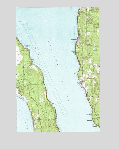
Camano, WA USGS Topographic Map
Click on map above to begin viewing in our Map Viewer.

This topographic map contains these locations and features:
Feature Name Type Latitude Longitude GNIS ID View Map
Cama BeachLocaleN48.1423°W122.5135°1503721View Map
CamanoPopulated PlaceN48.1740°W122.5282°1503722View Map
Camano ChapelChurchN48.1797°W122.5263°2609345View Map
Camano IslandIslandN48.1915°W122.5152°1533031View Map
Camp GrandeLocaleN48.2465°W122.5310°1503739View Map
Camp LagoonLocaleN48.2237°W122.5321°1503743View Map
Carp LakeLakeN48.2080°W122.5096°1503815View Map
Dry LakeLakeN48.1555°W122.5009°1504569View Map
Gilbertson PitMineN48.1684°W122.5018°2605626View Map
Greenbank Sand and Gravel QuarryMineN48.1285°W122.5811°2605684View Map
Harrington LagoonBayN48.2097°W122.6124°1505402View Map
Indian BeachPopulated PlaceN48.1632°W122.5213°1511050View Map
Island CountyCivilN48.1629°W122.5753°1513272View Map
Island County Fire District 1 Camano Island Fire and Rescue Station 1 Camano CityBuildingN48.1752°W122.5268°2606034View Map
Island County Fire District 1 Camano Island Fire and Rescue Station 4 Vista MadronaBuildingN48.2213°W122.5234°2606035View Map
Island County Fire District 5 Central Whidbey Island Fire and Rescue Station 52BuildingN48.2062°W122.6152°2643597View Map
Island County Fire District 5 Central Whidbey Island Fire and Rescue Station 53 HeadquartersBuildingN48.1731°W122.6037°2606041View Map
Madrona BeachPopulated PlaceN48.2173°W122.5340°1511113View Map
Miracle Mine QuarryMineN48.1995°W122.6226°2605639View Map
North BluffCliffN48.1376°W122.5665°1507019View Map
Onamac PointCapeN48.1840°W122.5365°1507187View Map
Race LagoonBayN48.1929°W122.5990°1507686View Map
Rockaway BeachPopulated PlaceN48.2054°W122.5365°1511265View Map
Rocky Point QuarryMineN48.2415°W122.5147°2605627View Map
Saratoga PassageChannelN48.1851°W122.5615°1508120View Map
Saratoga ShoresPopulated PlaceN48.1365°W122.5115°1511291View Map
Stanwood - Camano Yacht ClubLocaleN48.2162°W122.5371°2610322View Map
Sunset BeachPopulated PlaceN48.2143°W122.5349°1508840View Map
Woodland BeachLocaleN48.2029°W122.5368°1509618View Map

Note: Coordinates in the location and feature list above are referenced to NAD83 datum.


Copyright (C) 2008-2024 Ryan Niemi / Sunset Dynamics ... All Rights Reserved