TopoQuest Logo
Do you find TopoQuest useful?
Help keep TopoQuest running and adding new maps/features by donating!
Bitcoin:  19c7KJd3qBynnjoSw5npx9KScwjBe4ifkT
Litecoin:  LXs6TkuXGGXo1vDsWCkWVdjQX94eUKd6ui
Home View Maps Find Maps Find Places Resources & Links


Caledonia, Kentucky Topographic Map

USGS Map Title: Caledonia, KY
USGS Map MRC: 36087G6
DRG (GeoTIFF) Download: o36087g6.tif


Neighboring USGS Topographic Map Quads:


  Cobb, KY  
36087H7
 

  Gracey, KY  
36087H6
 

  Pleasant Green Hill, KY  
36087H5
 

  Cadiz, KY  
36087G7
 

  Caledonia, KY  
36087G6
 

  Church Hill, KY  
36087G5
 

  Johnson Hollow, KY  
36087F7
 

  Roaring Spring, KY  
36087F6
 

  Herndon, KY  
36087F5


Map MRC Location:

N37°
W88°
N37°
W87°
H8 H7 H6 H5 H4 H3 H2 H1
G8 G7 G6 G5 G4 G3 G2 G1
F8 F7 F6 F5 F4 F3 F2 F1
E8 E7 E6 E5 E4 E3 E2 E1
D8 D7 D6 D5 D4 D3 D2 D1
C8 C7 C6 C5 C4 C3 C2 C1
B8 B7 B6 B5 B4 B3 B2 B1
A8 A7 A6 A5 A4 A3 A2 A1
N36°
W88°
N36°
W87°

Caledonia, KY USGS 1:24K Topographic Map Preview:
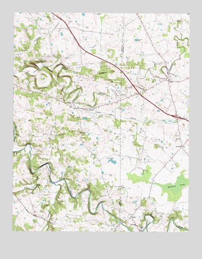
Caledonia, KY USGS Topographic Map
Click on map above to begin viewing in our Map Viewer.

This topographic map contains these locations and features:
Feature Name Type Latitude Longitude GNIS ID View Map
Bacon CemeteryCemeteryN36.8670°W87.6981°486194View Map
Binns MillPopulated PlaceN36.7525°W87.6597°507512View Map
Boatwright HoleBasinN36.8403°W87.6881°487590View Map
Boyd LakeLakeN36.8135°W87.6404°487771View Map
Boyd Lake BranchStreamN36.8228°W87.7025°487772View Map
CaledoniaPopulated PlaceN36.8203°W87.6950°507638View Map
Caledonia Volunteer Fire DepartmentBuildingN36.8217°W87.6908°2637330View Map
Casey CreekStreamN36.7778°W87.7218°489043View Map
Coon Cave SpringSpringN36.8469°W87.7308°490036View Map
Double PondLakeN36.7903°W87.6790°491045View Map
Garrett SpringSpringN36.7764°W87.7339°492727View Map
JulienPopulated PlaceN36.8367°W87.6397°508364View Map
Little River ChurchChurchN36.7542°W87.6628°496840View Map
Little River ChurchChurchN36.8292°W87.7297°496841View Map
Locust Grove Baptist ChurchChurchN36.8228°W87.7087°496952View Map
McGaughey SwampSwampN36.7767°W87.6339°497855View Map
Mill Stream SpringSpringN36.8439°W87.7133°498300View Map
Nancy CemeteryCemeteryN36.7687°W87.6572°499162View Map
NewsteadPopulated PlaceN36.7992°W87.6303°508700View Map
Newstead Presbyterian ChurchChurchN36.8039°W87.6323°499448View Map
Northington CemeteryCemeteryN36.7753°W87.6728°499603View Map
Old Presbyterian CemeteryCemeteryN36.7977°W87.6439°499871View Map
PeedeePopulated PlaceN36.7587°W87.6656°508793View Map
Potts CreekStreamN36.7842°W87.7333°501211View Map
Stapp CemeteryCemeteryN36.7903°W87.6789°504263View Map
Steele BranchStreamN36.8439°W87.7261°504305View Map
Stewart CemeteryCemeteryN36.8653°W87.7420°504379View Map
Taylor BluffCliffN36.7887°W87.7278°504985View Map
Ten Acre PondLakeN36.8597°W87.6631°505067View Map
Thomas CemeteryCemeteryN36.8695°W87.7103°505159View Map
Torian SpringsSpringN36.8701°W87.6338°505365View Map

Note: Coordinates in the location and feature list above are referenced to NAD83 datum.


Copyright (C) 2008-2024 Ryan Niemi / Sunset Dynamics ... All Rights Reserved