TopoQuest Logo
Do you find TopoQuest useful?
Help keep TopoQuest running and adding new maps/features by donating!
Bitcoin:  19c7KJd3qBynnjoSw5npx9KScwjBe4ifkT
Litecoin:  LXs6TkuXGGXo1vDsWCkWVdjQX94eUKd6ui
Home View Maps Find Maps Find Places Resources & Links


Cal Ship Mesa, New Mexico Topographic Map

USGS Map Title: Cal Ship Mesa, NM
USGS Map MRC: 34107C7
DRG (GeoTIFF) Download: o34107c7.tif


Neighboring USGS Topographic Map Quads:


  Third Canyon, NM  
34107D8
 

  Pasture Canyon, NM  
34107D7
 

  D Cross Mountain, NM  
34107D6
 

  Madre Mountain, NM  
34107C8
 

  Cal Ship Mesa, NM  
34107C7
 

  Dog Springs, NM  
34107C6
 

  Crosby Springs, NM  
34107B8
 

  Datil, NM  
34107B7
 

  Lion Mountain NW, NM  
34107B6


Map MRC Location:

N35°
W108°
N35°
W107°
H8 H7 H6 H5 H4 H3 H2 H1
G8 G7 G6 G5 G4 G3 G2 G1
F8 F7 F6 F5 F4 F3 F2 F1
E8 E7 E6 E5 E4 E3 E2 E1
D8 D7 D6 D5 D4 D3 D2 D1
C8 C7 C6 C5 C4 C3 C2 C1
B8 B7 B6 B5 B4 B3 B2 B1
A8 A7 A6 A5 A4 A3 A2 A1
N34°
W108°
N34°
W107°

Cal Ship Mesa, NM USGS 1:24K Topographic Map Preview:
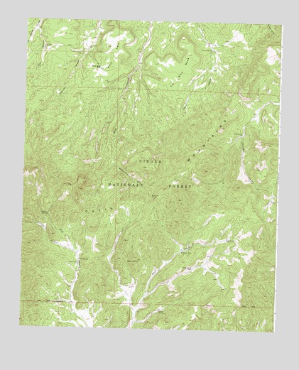
Cal Ship Mesa, NM USGS Topographic Map
Click on map above to begin viewing in our Map Viewer.

This topographic map contains these locations and features:
Feature Name Type Latitude Longitude GNIS ID View Map
Alamo Water WellWellN34.2867°W107.7748°918852View Map
Antelope WellWellN34.2867°W107.7748°903199View Map
Blue Place WellWellN34.2762°W107.8470°903952View Map
Blue SpringSpringN34.2777°W107.8467°903954View Map
Cal Ship MesaSummitN34.3678°W107.7987°904298View Map
Chavez SpringSpringN34.2575°W107.8072°905059View Map
Chinchbug WellWellN34.3295°W107.7684°905113View Map
Datil MountainsRangeN34.2909°W107.8398°905609View Map
Double Tanks WellWellN34.2667°W107.8206°905837View Map
Doubletank Water WellWellN34.2670°W107.8223°919768View Map
Gooseberry CanyonValleyN34.2814°W107.8495°906654View Map
Government TankReservoirN34.2747°W107.7913°906669View Map
Hidden SpringSpringN34.2770°W107.8234°1989140View Map
Kid SpringSpringN34.2773°W107.8231°906958View Map
Maverick CanyonValleyN34.3184°W107.8301°908471View Map
Maverick SpringSpringN34.3035°W107.8120°908480View Map
Ox SpringSpringN34.3653°W107.8737°937066View Map
Ox WellWellN34.3642°W107.8648°909412View Map
Pine CanyonValleyN34.3712°W107.8692°909659View Map
Pine WellWellN34.3028°W107.7520°1989139View Map
Remuda WellWellN34.3639°W107.8442°910120View Map
Sawhill WindmillLocaleN34.2592°W107.8573°919684View Map
Sawmill WellWellN34.2603°W107.8573°910856View Map
Skeleton SpringSpringN34.2962°W107.8630°911115View Map
Stiver SpringSpringN34.3634°W107.7839°911425View Map
Thompson CanyonValleyN34.3428°W107.7506°911661View Map
White MesaSummitN34.3603°W107.8328°912306View Map
White Mesa TankReservoirN34.3556°W107.8383°912308View Map
Williams TankReservoirN34.2817°W107.7970°912394View Map

Note: Coordinates in the location and feature list above are referenced to NAD83 datum.


Copyright (C) 2008-2024 Ryan Niemi / Sunset Dynamics ... All Rights Reserved