TopoQuest Logo
Do you find TopoQuest useful?
Help keep TopoQuest running and adding new maps/features by donating!
Bitcoin:  19c7KJd3qBynnjoSw5npx9KScwjBe4ifkT
Litecoin:  LXs6TkuXGGXo1vDsWCkWVdjQX94eUKd6ui
Home View Maps Find Maps Find Places Resources & Links


Cainsville, Missouri Topographic Map

USGS Map Title: Cainsville, MO
USGS Map MRC: 40093D7
DRG (GeoTIFF) Download: o40093d7.tif


Neighboring USGS Topographic Map Quads:


  Lamoni South, IA  
40093E8
 

  Akron, MO  
40093E7
 

  Pleasanton, IA  
40093E6
 

  Eagleville, MO  
40093D8
 

  Cainsville, MO  
40093D7
 

  Goshen, MO  
40093D6
 

  Gardner, MO  
40093C8
 

  Mount Moriah, MO  
40093C7
 

  Modena, MO  
40093C6


Map MRC Location:

N41°
W94°
N41°
W93°
H8 H7 H6 H5 H4 H3 H2 H1
G8 G7 G6 G5 G4 G3 G2 G1
F8 F7 F6 F5 F4 F3 F2 F1
E8 E7 E6 E5 E4 E3 E2 E1
D8 D7 D6 D5 D4 D3 D2 D1
C8 C7 C6 C5 C4 C3 C2 C1
B8 B7 B6 B5 B4 B3 B2 B1
A8 A7 A6 A5 A4 A3 A2 A1
N40°
W94°
N40°
W93°

Cainsville, MO USGS 1:24K Topographic Map Preview:
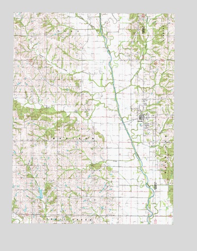
Cainsville, MO USGS Topographic Map
Click on map above to begin viewing in our Map Viewer.

This topographic map contains these locations and features:
Feature Name Type Latitude Longitude GNIS ID View Map
Banner SchoolSchoolN40.3944°W93.8111°713621View Map
Bohemian CemeteryCemeteryN40.3936°W93.8016°714485View Map
Booth Lake (historical)LakeN40.4011°W93.7622°714543View Map
Brush CreekStreamN40.4419°W93.7938°730063View Map
Brushy CreekStreamN40.4236°W93.7822°714905View Map
CainsvillePopulated PlaceN40.4375°W93.7752°758423View Map
Cainsville Elementary SchoolSchoolN40.4388°W93.7734°2545247View Map
Cainsville Fire Protection DistrictBuildingN40.4385°W93.7765°2621470View Map
Cainsville High SchoolSchoolN40.4390°W93.7736°2545263View Map
Cainsville Post OfficePost OfficeN40.4381°W93.7751°765601View Map
City of CainsvilleCivilN40.4398°W93.7747°2393490View Map
Coal CreekStreamN40.4525°W93.7955°716033View Map
Conner BranchStreamN40.4943°W93.7720°461471View Map
Crause School (historical)SchoolN40.4594°W93.7847°730078View Map
Donaby CreekStreamN40.4589°W93.7980°716969View Map
Donaby School (historical)SchoolN40.4967°W93.8705°716970View Map
Fairview Church (historical)ChurchN40.4756°W93.7827°717794View Map
Glaze Church (historical)ChurchN40.4467°W93.8224°718493View Map
Glaze SchoolSchoolN40.4553°W93.8219°718495View Map
Grants LakeReservoirN40.3830°W93.8648°760933View Map
Indian CreekStreamN40.4889°W93.8080°457790View Map
Keller School (historical)SchoolN40.4869°W93.7572°720500View Map
Little CreekStreamN40.4575°W93.7838°721210View Map
Lost CreekStreamN40.4175°W93.7799°721581View Map
Lynn SchoolSchoolN40.4244°W93.8263°721698View Map
Mlika Lake DamDamN40.3850°W93.8052°762729View Map
Moore School (historical)SchoolN40.4881°W93.7805°722589View Map
Panther Creek Watershed Dam D-1DamN40.3883°W93.8536°761196View Map
Panther Creek Watershed Dam F-10DamN40.3850°W93.8652°760932View Map
Pelzer LakeReservoirN40.4871°W93.8430°762731View Map
Pelzer Lake DamDamN40.4867°W93.8436°762730View Map
Phoenix SchoolSchoolN40.4244°W93.8594°724300View Map
Reeder LakeReservoirN40.3917°W93.8530°761197View Map
Snowball School (historical)SchoolN40.4558°W93.8605°726677View Map
Township of MadisonCivilN40.4261°W93.8222°766725View Map
Victor SchoolSchoolN40.4858°W93.8183°728185View Map
Whiteoak School (historical)SchoolN40.3950°W93.8472°728783View Map

Note: Coordinates in the location and feature list above are referenced to NAD83 datum.


Copyright (C) 2008-2024 Ryan Niemi / Sunset Dynamics ... All Rights Reserved