TopoQuest Logo
Do you find TopoQuest useful?
Help keep TopoQuest running and adding new maps/features by donating!
Bitcoin:  19c7KJd3qBynnjoSw5npx9KScwjBe4ifkT
Litecoin:  LXs6TkuXGGXo1vDsWCkWVdjQX94eUKd6ui
Home View Maps Find Maps Find Places Resources & Links


Burrows, Indiana Topographic Map

USGS Map Title: Burrows, IN
USGS Map MRC: 40086F5
DRG (GeoTIFF) Download: o40086f5.tif


Neighboring USGS Topographic Map Quads:


  Idaville, IN  
40086G6
 

  Burnettsville, IN  
40086G5
 

  Lucerne, IN  
40086G4
 

  Yeoman, IN  
40086F6
 

  Burrows, IN  
40086F5
 

  Clymers, IN  
40086F4
 

  Delphi, IN  
40086E6
 

  Flora, IN  
40086E5
 

  Deer Creek, IN  
40086E4


Map MRC Location:

N41°
W87°
N41°
W86°
H8 H7 H6 H5 H4 H3 H2 H1
G8 G7 G6 G5 G4 G3 G2 G1
F8 F7 F6 F5 F4 F3 F2 F1
E8 E7 E6 E5 E4 E3 E2 E1
D8 D7 D6 D5 D4 D3 D2 D1
C8 C7 C6 C5 C4 C3 C2 C1
B8 B7 B6 B5 B4 B3 B2 B1
A8 A7 A6 A5 A4 A3 A2 A1
N40°
W87°
N40°
W86°

Burrows, IN USGS 1:24K Topographic Map Preview:
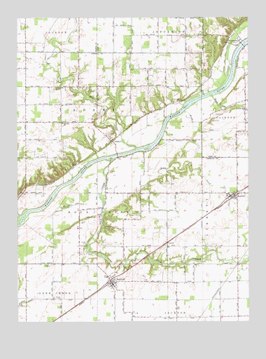
Burrows, IN USGS Topographic Map
Click on map above to begin viewing in our Map Viewer.

This topographic map contains these locations and features:
Feature Name Type Latitude Longitude GNIS ID View Map
Benner DitchCanalN40.7034°W86.5253°430809View Map
Brown Church CemeteryCemeteryN40.6702°W86.5588°431605View Map
Burnetts CreekStreamN40.6961°W86.5606°431851View Map
BurrowsPopulated PlaceN40.6767°W86.5075°431874View Map
Burrows Fire DepartmentBuildingN40.6773°W86.5115°2625727View Map
Crooked CreekStreamN40.7212°W86.5144°433159View Map
FlaxPopulated PlaceN40.6417°W86.5167°446703View Map
GeorgetownPopulated PlaceN40.7406°W86.5047°435024View Map
Georgetown Volunteer Fire DepartmentBuildingN40.7412°W86.5052°2626591View Map
Great Eastern CemeteryCemeteryN40.7289°W86.5324°435381View Map
Independent Order of Odd Fellows CemeteryCemeteryN40.6481°W86.5686°436689View Map
Johnson City CemeteryCemeteryN40.7158°W86.5367°437042View Map
Keeps CreekStreamN40.7184°W86.5203°437191View Map
Little Rock CreekStreamN40.6953°W86.5569°438133View Map
LockportPopulated PlaceN40.6992°W86.5736°438202View Map
Mullendore CemeteryCemeteryN40.6684°W86.5821°439870View Map
Parks - Groninger CemeteryCemeteryN40.6567°W86.5887°440892View Map
Pleasant Hill ChurchChurchN40.7125°W86.5011°441283View Map
Rattlesnake CreekStreamN40.6681°W86.6236°441783View Map
Rock CreekStreamN40.6923°W86.5725°442194View Map
RockfieldPopulated PlaceN40.6411°W86.5739°442217View Map
Rockfield Fire DepartmentBuildingN40.6410°W86.5742°2625556View Map
Seceder CemeteryCemeteryN40.7215°W86.6052°443187View Map
Township of AdamsCivilN40.7053°W86.6067°453074View Map
Township of LibertyCivilN40.6664°W86.5083°453550View Map
Township of Rock CreekCivilN40.6644°W86.5787°453809View Map
Whistler CemeteryCemeteryN40.6346°W86.6019°445911View Map

Note: Coordinates in the location and feature list above are referenced to NAD83 datum.


Copyright (C) 2008-2024 Ryan Niemi / Sunset Dynamics ... All Rights Reserved