TopoQuest Logo
Do you find TopoQuest useful?
Help keep TopoQuest running and adding new maps/features by donating!
Bitcoin:  19c7KJd3qBynnjoSw5npx9KScwjBe4ifkT
Litecoin:  LXs6TkuXGGXo1vDsWCkWVdjQX94eUKd6ui
Home View Maps Find Maps Find Places Resources & Links


Burris Park, California Topographic Map

USGS Map Title: Burris Park, CA
USGS Map MRC: 36119D5
DRG (GeoTIFF) Download: o36119d5.tif


Neighboring USGS Topographic Map Quads:


  Conejo, CA  
36119E6
 

  Selma, CA  
36119E5
 

  Reedley, CA  
36119E4
 

  Laton, CA  
36119D6
 

  Burris Park, CA  
36119D5
 

  Traver, CA  
36119D4
 

  Hanford, CA  
36119C6
 

  Remnoy, CA  
36119C5
 

  Goshen, CA  
36119C4


Map MRC Location:

N37°
W120°
N37°
W119°
H8 H7 H6 H5 H4 H3 H2 H1
G8 G7 G6 G5 G4 G3 G2 G1
F8 F7 F6 F5 F4 F3 F2 F1
E8 E7 E6 E5 E4 E3 E2 E1
D8 D7 D6 D5 D4 D3 D2 D1
C8 C7 C6 C5 C4 C3 C2 C1
B8 B7 B6 B5 B4 B3 B2 B1
A8 A7 A6 A5 A4 A3 A2 A1
N36°
W120°
N36°
W119°

Burris Park, CA USGS 1:24K Topographic Map Preview:
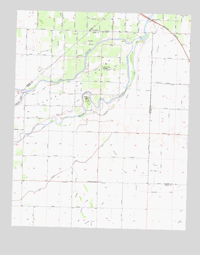
Burris Park, CA USGS Topographic Map
Click on map above to begin viewing in our Map Viewer.

This topographic map contains these locations and features:
Feature Name Type Latitude Longitude GNIS ID View Map
Bishop CanalCanalN36.4963°W119.5562°239352View Map
Burris ParkParkN36.4486°W119.5751°239875View Map
Clough DitchCanalN36.4325°W119.5154°240712View Map
Dias and Dias Dairy ComplexLocaleN36.4469°W119.5800°2703522View Map
Dover DairyLocaleN36.4119°W119.5339°2703851View Map
Excelsior SchoolSchoolN36.4019°W119.5662°242120View Map
Fagundes RanchLocaleN36.3856°W119.5889°2515612View Map
Five J's DairyLocaleN36.4275°W119.5456°2703528View Map
Hanford Northeast DivisionCivilN36.3966°W119.5963°1935128View Map
Island CanalCanalN36.4675°W119.5582°243923View Map
Kings County Fire Department Station 1 Burris ParkBuildingN36.4522°W119.5743°2624076View Map
KJET-FM (Kingsburg)TowerN36.4472°W119.6210°1665048View Map
KJET-FM (Kingsburg)TowerN36.4472°W119.5996°1665049View Map
Lakeland CanalCanalN36.4144°W119.5379°244536View Map
McClanahan DitchCanalN36.4866°W119.5140°245649View Map
North Branch Island CanalCanalN36.4572°W119.5996°246594View Map
Peoples Weir 79DamN36.4860°W119.5366°1663537View Map
River Bend SchoolSchoolN36.4675°W119.5637°248230View Map
Riverside DitchCanalN36.4311°W119.6068°248242View Map
Settlers DitchCanalN36.3847°W119.5646°249302View Map
South Branch Island CanalCanalN36.4463°W119.5835°249682View Map
Triple F RanchLocaleN36.3786°W119.5850°2515616View Map
Ward Drainage CanalCanalN36.4858°W119.5962°251168View Map
Willow Grove Farms DairyLocaleN36.3811°W119.5444°2703650View Map

Note: Coordinates in the location and feature list above are referenced to NAD83 datum.


Copyright (C) 2008-2024 Ryan Niemi / Sunset Dynamics ... All Rights Reserved