TopoQuest Logo
Do you find TopoQuest useful?
Help keep TopoQuest running and adding new maps/features by donating!
Bitcoin:  19c7KJd3qBynnjoSw5npx9KScwjBe4ifkT
Litecoin:  LXs6TkuXGGXo1vDsWCkWVdjQX94eUKd6ui
Home View Maps Find Maps Find Places Resources & Links


Burnt Corn, Alabama Topographic Map

USGS Map Title: Burnt Corn, AL
USGS Map MRC: 31087E2
DRG (GeoTIFF) Download: o31087e2.tif


Neighboring USGS Topographic Map Quads:


  Natchez, AL  
31087F3
 

  Beatrice, AL  
31087F2
 

  Skinnerton, AL  
31087F1
 

  Monroeville, AL  
31087E3
 

  Burnt Corn, AL  
31087E2
 

  China, AL  
31087E1
 

  Excel, AL  
31087D3
 

  Repton, AL  
31087D2
 

  Belleville, AL  
31087D1


Map MRC Location:

N32°
W88°
N32°
W87°
H8 H7 H6 H5 H4 H3 H2 H1
G8 G7 G6 G5 G4 G3 G2 G1
F8 F7 F6 F5 F4 F3 F2 F1
E8 E7 E6 E5 E4 E3 E2 E1
D8 D7 D6 D5 D4 D3 D2 D1
C8 C7 C6 C5 C4 C3 C2 C1
B8 B7 B6 B5 B4 B3 B2 B1
A8 A7 A6 A5 A4 A3 A2 A1
N31°
W88°
N31°
W87°

Burnt Corn, AL USGS 1:24K Topographic Map Preview:
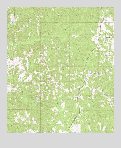
Burnt Corn, AL USGS Topographic Map
Click on map above to begin viewing in our Map Viewer.

This topographic map contains these locations and features:
Feature Name Type Latitude Longitude GNIS ID View Map
Academy SpringSpringN31.5557°W87.1583°147414View Map
Bethany Baptist ChurchChurchN31.5396°W87.1755°136486View Map
Bethany CemeteryCemeteryN31.5388°W87.1755°1805639View Map
Bethel ChurchChurchN31.5904°W87.1722°136487View Map
Booker School (historical)SchoolN31.5907°W87.1339°133095View Map
Burnt CornPopulated PlaceN31.5535°W87.1603°115265View Map
Burnt Corn Academy (historical)SchoolN31.5557°W87.1589°147417View Map
Burnt Corn Community ChurchChurchN31.5496°W87.1928°154595View Map
Burnt Corn Methodist ChurchChurchN31.5502°W87.1589°147418View Map
Burnt Corn Volunteer Fire DepartmentBuildingN31.5476°W87.1612°2691164View Map
Glendale Church (historical)ChurchN31.6063°W87.2072°136525View Map
Green StreetPopulated PlaceN31.5771°W87.1308°119350View Map
Green Street ChurchChurchN31.5824°W87.1311°133120View Map
Greenfield School (historical)SchoolN31.5732°W87.2419°136530View Map
Greys Store (historical)LocaleN31.5993°W87.1494°136594View Map
Harpers StorePopulated PlaceN31.5940°W87.1347°119776View Map
John Green CemeteryCemeteryN31.5418°W87.1383°147425View Map
Lee CemeteryCemeteryN31.5396°W87.1314°147426View Map
McKinney BranchStreamN31.5935°W87.1875°136560View Map
New Hope African Methodist Episcopal ChurchChurchN31.5371°W87.1347°123801View Map
New Hope CemeteryCemeteryN31.5377°W87.1353°1805502View Map
Pilgrim Rest ChurchChurchN31.5491°W87.1933°124733View Map
Puryearville (historical)Populated PlaceN31.5474°W87.1900°151458View Map
Puryearville CemeteryCemeteryN31.5452°W87.1922°1730551View Map
Puryearville Methodist Church (historical)ChurchN31.5460°W87.1922°136614View Map
RamahPopulated PlaceN31.6124°W87.1375°156943View Map
Ramah Baptist ChurchChurchN31.6127°W87.1386°136617View Map
Ramah CemeteryCemeteryN31.6121°W87.1386°136616View Map
Rumbley CemeteryCemeteryN31.5721°W87.2464°126016View Map
Salem Baptist ChurchChurchN31.5497°W87.1599°2580377View Map
Zion Church (historical)ChurchN31.5877°W87.1661°136654View Map

Note: Coordinates in the location and feature list above are referenced to NAD83 datum.


Copyright (C) 2008-2024 Ryan Niemi / Sunset Dynamics ... All Rights Reserved