TopoQuest Logo
Do you find TopoQuest useful?
Help keep TopoQuest running and adding new maps/features by donating!
Bitcoin:  19c7KJd3qBynnjoSw5npx9KScwjBe4ifkT
Litecoin:  LXs6TkuXGGXo1vDsWCkWVdjQX94eUKd6ui
Home View Maps Find Maps Find Places Resources & Links


Bulls Gap, Tennessee Topographic Map

USGS Map Title: Bulls Gap, TN
USGS Map MRC: 36083C1
DRG (GeoTIFF) Download: o36083c1.tif


Neighboring USGS Topographic Map Quads:


  Lee Valley, TN  
36083D2
 

  Camelot, TN  
36083D1
 

  Burem, TN  
36082D8
 

  Russellville, TN  
36083C2
 

  Bulls Gap, TN  
36083C1
 

  McCloud, TN  
36082C8
 

  Springvale, TN  
36083B2
 

  Mohawk, TN  
36083B1
 

  Mosheim, TN  
36082B8


Map MRC Location:

N37°
W84°
N37°
W83°
H8 H7 H6 H5 H4 H3 H2 H1
G8 G7 G6 G5 G4 G3 G2 G1
F8 F7 F6 F5 F4 F3 F2 F1
E8 E7 E6 E5 E4 E3 E2 E1
D8 D7 D6 D5 D4 D3 D2 D1
C8 C7 C6 C5 C4 C3 C2 C1
B8 B7 B6 B5 B4 B3 B2 B1
A8 A7 A6 A5 A4 A3 A2 A1
N36°
W84°
N36°
W83°

Bulls Gap, TN USGS 1:24K Topographic Map Preview:
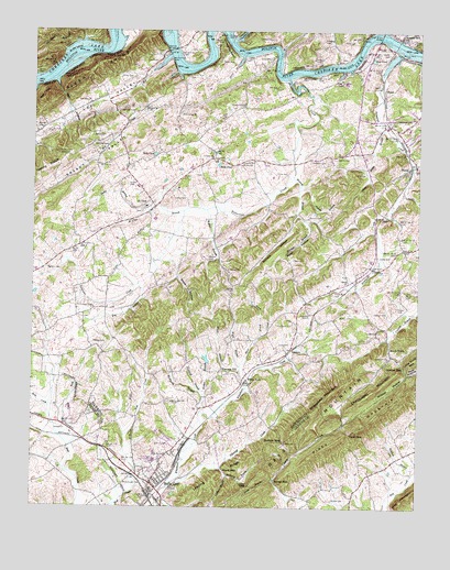
Bulls Gap, TN USGS Topographic Map
Click on map above to begin viewing in our Map Viewer.

This topographic map contains these locations and features:
Feature Name Type Latitude Longitude GNIS ID View Map
Arnott BranchStreamN36.2948°W83.0510°1275897View Map
Austins MillPopulated PlaceN36.3734°W83.0066°1304901View Map
Bacon CemeteryCemeteryN36.3420°W83.0268°1276064View Map
Barnett HollowValleyN36.3268°W83.0395°1304966View Map
Beal PondLakeN36.3676°W83.0152°1276530View Map
Beech GrovePopulated PlaceN36.2920°W83.0091°1314650View Map
Beech Grove School (historical)SchoolN36.2934°W83.0088°1308411View Map
Bell HillSummitN36.3570°W83.1218°1276927View Map
Bell HollowValleyN36.3615°W83.1180°1276938View Map
Berry CemeteryCemeteryN36.3154°W83.0407°1277053View Map
Brookes Island (historical)IslandN36.3734°W83.0993°1308476View Map
Brown CemeteryCemeteryN36.2523°W83.0271°1278557View Map
Bryant BranchStreamN36.3345°W83.0385°1278734View Map
Bulls GapPopulated PlaceN36.2570°W83.0860°1269404View Map
Bulls Gap Division (historical)CensusN36.3184°W83.0271°1648758View Map
Bulls Gap High SchoolSchoolN36.2623°W83.0849°1305524View Map
Bulls Gap Post OfficePost OfficeN36.2569°W83.0866°1649633View Map
Bulls Gap Volunteer Fire DepartmentBuildingN36.2573°W83.0838°2654522View Map
Bulls Gap Volunteer Fire Department Station 2BuildingN36.3297°W83.0839°2654320View Map
Burdine CemeteryCemeteryN36.3129°W83.1204°1279031View Map
Caldwell CemeteryCemeteryN36.3731°W83.0482°1305595View Map
Caney ForkStreamN36.2687°W83.1154°1279570View Map
Cantrell PondLakeN36.3414°W83.0619°1310114View Map
Cedar Grove CemeteryCemeteryN36.3731°W83.0021°1280035View Map
Cherokee LakeReservoirN36.3734°W83.0620°1280322View Map
Chestnut CemeteryCemeteryN36.3415°W83.0352°1280373View Map
Chestnut CemeteryCemeteryN36.3726°W83.0315°1280374View Map
Chinquapin MountainSummitN36.2807°W83.0143°1280490View Map
Cloud ShoalsBarN36.3745°W83.0832°1308438View Map
Coldsprings BranchStreamN36.2501°W83.0799°1269478View Map
Commissioner District 7CivilN36.3292°W83.0393°2464615View Map
CoranPopulated PlaceN36.3595°W83.0116°1314890View Map
Couch CemeteryCemeteryN36.3026°W83.0065°1281373View Map
Courtney CemeteryCemeteryN36.3456°W83.1043°1281396View Map
Coward CemeteryCemeteryN36.2965°W83.0124°1281463View Map
Coward CemeteryCemeteryN36.3345°W83.0946°1281464View Map
Coward CemeteryCemeteryN36.3684°W83.0488°1281465View Map
Coxes ShoalsBarN36.3657°W83.0318°1642842View Map
Crockett CreekStreamN36.3723°W83.0616°1306183View Map
Davis CemeteryCemeteryN36.3723°W83.0215°1282163View Map
Days GapGapN36.2695°W83.0216°1306292View Map
Dotson CemeteryCemeteryN36.3012°W83.0140°1282674View Map
Drumhole ShoalsBarN36.3681°W83.1132°1308429View Map
Dry BranchStreamN36.3087°W83.0907°1282861View Map
East Fork Bent CreekStreamN36.2690°W83.0949°1308442View Map
Ed Berry CemeteryCemeteryN36.2984°W83.0407°1283499View Map
Fair View ChurchChurchN36.3562°W83.1068°1283973View Map
Flora CemeteryCemeteryN36.3629°W83.0971°1284498View Map
Flora Ferry (historical)CrossingN36.3698°W83.0460°1308445View Map
Frank Berry CemeteryCemeteryN36.3070°W83.0271°1284809View Map
Gulley CemeteryCemeteryN36.3065°W83.0610°1286394View Map
Gulley CemeteryCemeteryN36.3312°W83.0799°1286395View Map
Guthrie CemeteryCemeteryN36.2662°W83.0807°1286456View Map
Guthrie GapGapN36.2676°W83.0432°1286457View Map
Guthrie Gap ChurchChurchN36.2670°W83.0432°1286458View Map
Heck CemeteryCemeteryN36.3676°W83.0857°1287316View Map
Heck PondLakeN36.3426°W83.0857°1287319View Map
Honeycutt CreekStreamN36.3695°W83.0068°1288218View Map
Hopewell Baptist ChurchChurchN36.3009°W83.0352°1288317View Map
Horseshoe BendBendN36.3704°W83.0646°1288436View Map
Hugh B Day BridgeBridgeN36.3737°W83.0127°1288656View Map
King CemeteryCemeteryN36.3381°W83.0174°1290211View Map
Lauthner BranchStreamN36.2584°W83.0613°1290767View Map
Leading RidgeRidgeN36.2573°W83.0657°1290867View Map
Lee ValleyValleyN36.3687°W83.0813°1290968View Map
Liberty ChurchChurchN36.3420°W83.0674°1291142View Map
Liberty Hill ChurchChurchN36.3401°W83.0571°1291160View Map
Liberty School (historical)SchoolN36.3415°W83.0532°1308474View Map
Lollar BranchStreamN36.2570°W83.0460°1291829View Map
Lollar GapGapN36.2559°W83.0541°1291830View Map
Long CemeteryCemeteryN36.2931°W83.0413°1291925View Map
Long CemeteryCemeteryN36.3379°W83.0465°1291926View Map
Longtown (historical)Populated PlaceN36.3320°W83.0582°1310117View Map
Malinda BridgeBridgeN36.3701°W83.0810°1292528View Map
McBride CemeteryCemeteryN36.3543°W83.0927°1293090View Map
McCullough CemeteryCemeteryN36.2568°W83.0946°1293228View Map
McPheron BranchStreamN36.2748°W83.0699°1293454View Map
Mills PondLakeN36.3400°W83.0650°1293993View Map
Mooney BranchStreamN36.3373°W83.0410°1294228View Map
Mooney CemeteryCemeteryN36.3265°W83.0357°1294229View Map
Mooney CemeteryCemeteryN36.3723°W83.0666°1294230View Map
Moore BranchStreamN36.2812°W83.0557°1294244View Map
Morelock BranchStreamN36.2590°W83.0013°1294343View Map
Morrisett ChapelChurchN36.3429°W83.1157°1294441View Map
Mount Zion Baptist ChurchChurchN36.3398°W83.1038°1294911View Map
Mulberry BranchStreamN36.2601°W83.0635°1295055View Map
New Hope Church (historical)ChurchN36.3618°W83.0754°1308498View Map
Oak Grove ChurchChurchN36.2637°W83.0807°1296109View Map
OtesPopulated PlaceN36.3090°W83.0229°1315660View Map
Otes United Methodist ChurchChurchN36.3090°W83.0235°1320160View Map
PersiaPopulated PlaceN36.3398°W83.0029°1297226View Map
Persia School (historical)SchoolN36.3426°W83.0021°1642872View Map
Phillips CemeteryCemeteryN36.2931°W83.1007°1297350View Map
Pikestaff CreekStreamN36.2565°W83.0791°1297463View Map
Pleasant HillPopulated PlaceN36.2857°W83.0646°1315738View Map
Pleasant Hill ChurchChurchN36.2843°W83.0627°1308505View Map
Pleasant Hill School (historical)SchoolN36.2854°W83.0627°1310119View Map
Price CemeteryCemeteryN36.3701°W83.0749°1298504View Map
Price Grove ChurchChurchN36.3534°W83.0782°1298511View Map
Prices Ferry (historical)CrossingN36.3698°W83.0804°1308487View Map
Rader GapGapN36.2568°W83.0460°1298805View Map
Reynolds CemeteryCemeteryN36.3518°W83.0071°1299256View Map
Rices Ferry (historical)CrossingN36.3662°W83.0777°1642878View Map
River KnobsRidgeN36.3643°W83.1066°1299497View Map
Robertson CreekStreamN36.3626°W83.0429°1299668View Map
Robertson Creek ChurchChurchN36.3023°W83.1052°1299669View Map
Robertson Creek School (historical)SchoolN36.3023°W83.1046°1308511View Map
Rocky BranchStreamN36.3276°W83.0868°1299868View Map
Rush HollowValleyN36.3252°W83.0365°1300267View Map
Saint ClairPopulated PlaceN36.3307°W83.0871°1300427View Map
Saint Clair BranchStreamN36.3279°W83.0763°1300428View Map
Saint Clair Elementary SchoolSchoolN36.3287°W83.0882°1308517View Map
Saint Clair ParkParkN36.3293°W83.0874°1647058View Map
Saint Clair United Methodist ChurchChurchN36.3287°W83.0888°1320084View Map
Seay HollowValleyN36.2853°W83.0026°1301007View Map
Self CemeteryCemeteryN36.3323°W83.0049°1301043View Map
Shanks RippleRapidsN36.3726°W83.1002°1642881View Map
Sheepbed MountainSummitN36.2809°W83.0266°1303554View Map
Shepherd BranchStreamN36.2804°W83.0704°1270039View Map
Shepherd CemeteryCemeteryN36.2768°W83.0829°1303565View Map
Short CreekStreamN36.2859°W83.0577°1303606View Map
Smith CemeteryCemeteryN36.3162°W83.0088°1270634View Map
Smith CemeteryCemeteryN36.3693°W83.0102°1270637View Map
Smiths Islands (historical)IslandN36.3734°W83.0113°1642884View Map
Smiths ShoalsBarN36.3726°W83.0091°1642885View Map
Snow HollowValleyN36.3151°W83.0790°1270787View Map
Speedwell ChurchChurchN36.2895°W83.0096°1303747View Map
Stamp GapGapN36.2865°W83.0041°1271210View Map
SummitLocaleN36.2904°W83.0424°1271846View Map
Summit Hill School (historical)SchoolN36.3007°W83.0343°1308533View Map
Tarter BranchStreamN36.3684°W83.0579°1272139View Map
Tarter CemeteryCemeteryN36.3668°W83.0613°1272140View Map
Taylor BluffCliffN36.3684°W83.0996°1304015View Map
Thorps ChapelChurchN36.3554°W83.0574°1272577View Map
Thorps Church (historical)ChurchN36.3548°W83.0521°1308538View Map
Thorps School (historical)SchoolN36.3557°W83.0566°1308539View Map
Three Forks BranchStreamN36.3495°W83.0121°1272578View Map
Town of Bulls GapCivilN36.2617°W83.0783°2405342View Map
Walker BranchStreamN36.2787°W83.0691°1273568View Map
Walker BranchStreamN36.3284°W83.0691°1273569View Map
Walker CemeteryCemeteryN36.3009°W83.0249°1273609View Map
Walker CemeteryCemeteryN36.3126°W83.0615°1273610View Map
Walker CemeteryCemeteryN36.3473°W83.1057°1273611View Map
Walker CemeteryCemeteryN36.3156°W83.0682°1304334View Map
Walkers School (historical)SchoolN36.3126°W83.0618°1308548View Map
War CreekStreamN36.3687°W83.0813°1273765View Map
Ward GapGapN36.2595°W83.0624°1273786View Map
White HornPopulated PlaceN36.2845°W83.0560°1314500View Map
White Horn ChurchChurchN36.2779°W83.0793°1304521View Map
Whitesburg BranchStreamN36.2684°W83.1157°1311727View Map
Whiteside CemeteryCemeteryN36.3631°W83.0749°1310120View Map
Wildcat HollowValleyN36.2845°W83.0035°1274545View Map
Wolfe BranchStreamN36.2870°W83.0574°1274983View Map

Note: Coordinates in the location and feature list above are referenced to NAD83 datum.


Copyright (C) 2008-2024 Ryan Niemi / Sunset Dynamics ... All Rights Reserved