TopoQuest Logo
Do you find TopoQuest useful?
Help keep TopoQuest running and adding new maps/features by donating!
Bitcoin:  19c7KJd3qBynnjoSw5npx9KScwjBe4ifkT
Litecoin:  LXs6TkuXGGXo1vDsWCkWVdjQX94eUKd6ui
Home View Maps Find Maps Find Places Resources & Links


Bullfrog, Utah Topographic Map

USGS Map Title: Bullfrog, UT
USGS Map MRC: 37110E6
DRG (GeoTIFF) Download: o37110e6.tif


Neighboring USGS Topographic Map Quads:


  Clay Point, UT  
37110F7
 

  Lost Spring, UT  
37110F6
 

  Ticaboo Mesa, UT  
37110F5
 

  Hall Mesa, UT  
37110E7
 

  Bullfrog, UT  
37110E6
 

  Knowles Canyon, UT  
37110E5
 

  The Rincon NE, UT  
37110D7
 

  Halls Crossing, UT  
37110D6
 

  Halls Crossing NE, UT  
37110D5


Map MRC Location:

N38°
W111°
N38°
W110°
H8 H7 H6 H5 H4 H3 H2 H1
G8 G7 G6 G5 G4 G3 G2 G1
F8 F7 F6 F5 F4 F3 F2 F1
E8 E7 E6 E5 E4 E3 E2 E1
D8 D7 D6 D5 D4 D3 D2 D1
C8 C7 C6 C5 C4 C3 C2 C1
B8 B7 B6 B5 B4 B3 B2 B1
A8 A7 A6 A5 A4 A3 A2 A1
N37°
W111°
N37°
W110°

Bullfrog, UT USGS 1:24K Topographic Map Preview:
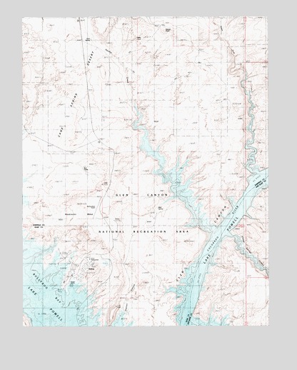
Bullfrog, UT USGS Topographic Map
Click on map above to begin viewing in our Map Viewer.

This topographic map contains these locations and features:
Feature Name Type Latitude Longitude GNIS ID View Map
BullfrogLocaleN37.5250°W110.7140°1435217View Map
Bullfrog Basin AirportAirportN37.5439°W110.7140°1434547View Map
Bullfrog Basin CampgroundLocaleN37.5222°W110.7215°1426102View Map
Bullfrog Basin MarinaLocaleN37.5161°W110.7285°1455198View Map
Bullfrog BayBayN37.5250°W110.7479°1450267View Map
Cane SpringSpringN37.6108°W110.7060°1426331View Map
Danish KnollSummitN37.6194°W110.6782°1427209View Map
Elbow BarBarN37.5072°W110.6701°1450347View Map
Hansen CreekStreamN37.5797°W110.6932°1428517View Map
Hoskinnini MesaSummitN37.5478°W110.7090°1428899View Map
Moki TankReservoirN37.6162°W110.6925°1430403View Map
Moqui BarBarN37.5072°W110.6701°1450434View Map
National Park Service HeadquartersLocaleN37.5272°W110.7163°1436023View Map
Painted Hill RV ParkParkN37.5667°W110.7235°1436087View Map
Red TanksReservoirN37.5638°W110.7200°1431705View Map
Smith BarBarN37.5361°W110.6557°1450501View Map
Smith ForkStreamN37.5992°W110.6396°1432568View Map
Stanton CanyonValleyN37.5047°W110.6996°1432913View Map
U.S. Forest Service ClinicHospitalN37.5167°W110.7090°1436545View Map
United States Forest Service Clinic HeliportAirportN37.5167°W110.7090°1436546View Map
Wolf SpringSpringN37.5477°W110.6818°1436661View Map

Note: Coordinates in the location and feature list above are referenced to NAD83 datum.


Copyright (C) 2008-2024 Ryan Niemi / Sunset Dynamics ... All Rights Reserved