TopoQuest Logo
Do you find TopoQuest useful?
Help keep TopoQuest running and adding new maps/features by donating!
Bitcoin:  19c7KJd3qBynnjoSw5npx9KScwjBe4ifkT
Litecoin:  LXs6TkuXGGXo1vDsWCkWVdjQX94eUKd6ui
Home View Maps Find Maps Find Places Resources & Links


Bullard, Texas Topographic Map

USGS Map Title: Bullard, TX
USGS Map MRC: 32095B3
DRG (GeoTIFF) Download: o32095b3.tif


Neighboring USGS Topographic Map Quads:


  Chandler, TX  
32095C4
 

  Tyler South, TX  
32095C3
 

  Bascom, TX  
32095C2
 

  Saline Bay, TX  
32095B4
 

  Bullard, TX  
32095B3
 

  Troup West, TX  
32095B2
 

  Berryville, TX  
32095A4
 

  Mount Selman, TX  
32095A3
 

  Tecula, TX  
32095A2


Map MRC Location:

N33°
W96°
N33°
W95°
H8 H7 H6 H5 H4 H3 H2 H1
G8 G7 G6 G5 G4 G3 G2 G1
F8 F7 F6 F5 F4 F3 F2 F1
E8 E7 E6 E5 E4 E3 E2 E1
D8 D7 D6 D5 D4 D3 D2 D1
C8 C7 C6 C5 C4 C3 C2 C1
B8 B7 B6 B5 B4 B3 B2 B1
A8 A7 A6 A5 A4 A3 A2 A1
N32°
W96°
N32°
W95°

Bullard, TX USGS 1:24K Topographic Map Preview:
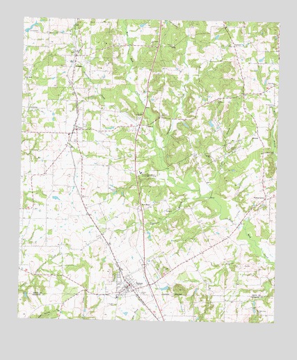
Bullard, TX USGS Topographic Map
Click on map above to begin viewing in our Map Viewer.

This topographic map contains these locations and features:
Feature Name Type Latitude Longitude GNIS ID View Map
AntiochPopulated PlaceN32.2021°W95.2588°1377942View Map
Antioch CemeteryCemeteryN32.1977°W95.2733°1329595View Map
Antioch ChurchChurchN32.1940°W95.2819°1329603View Map
Barron CemeteryCemeteryN32.2399°W95.3008°1330087View Map
Bishop ChurchChurchN32.1710°W95.3033°1330718View Map
BullardPopulated PlaceN32.1399°W95.3202°1331622View Map
Bullard City HallBuildingN32.1386°W95.3214°2753375View Map
Bullard Fire Department Station 1BuildingN32.1387°W95.3197°2655161View Map
Bullard Police DepartmentBuildingN32.1386°W95.3214°2751182View Map
Bullard Post OfficePost OfficeN32.1425°W95.3180°2731407View Map
CopelandPopulated PlaceN32.2399°W95.2719°1378156View Map
Crow CemeteryCemeteryN32.1946°W95.2905°1333738View Map
Dean BranchStreamN32.1768°W95.2872°1334159View Map
Douglas CemeteryCemeteryN32.1315°W95.3272°1334551View Map
East Texas Guidance and Achievement CenterLocaleN32.1865°W95.3155°1384364View Map
FlintPopulated PlaceN32.2040°W95.3486°1335957View Map
Flint - Gresham Fire Department Station 2BuildingN32.2478°W95.3483°2655439View Map
Flint - Gresham Volunteer Fire Department Station 1BuildingN32.2065°W95.3481°2655332View Map
Flint CemeteryCemeteryN32.1993°W95.3469°1335959View Map
Flint Post OfficePost OfficeN32.2046°W95.3457°2731713View Map
French FieldAirportN32.1342°W95.3392°2717038View Map
Grace Chapel Assembly of God ChurchChurchN32.2343°W95.3111°2023540View Map
GreshamPopulated PlaceN32.2293°W95.3494°1378384View Map
Henshaw CreekStreamN32.1999°W95.3091°1337629View Map
Lee SpringPopulated PlaceN32.2127°W95.3719°1378575View Map
Lee Spring ChurchChurchN32.2254°W95.3733°1339791View Map
Mount Elm ChurchChurchN32.2243°W95.2519°1342035View Map
Mount Nebo ChurchChurchN32.1290°W95.2580°1342062View Map
Mount Zion ChurchChurchN32.2102°W95.3066°1342144View Map
Nazarene Parsonage Flint ChurchChurchN32.1990°W95.3433°2023412View Map
New Bethel ChurchChurchN32.2407°W95.3116°1342434View Map
New HopePopulated PlaceN32.1713°W95.3147°1378740View Map
Owens Elementary SchoolSchoolN32.2335°W95.3644°2008805View Map
Patriots ChurchChurchN32.2057°W95.3133°1343667View Map
Pineridge AirportAirportN32.2213°W95.3174°1387661View Map
Rather CemeteryCemeteryN32.1796°W95.3277°1344806View Map
Ray CemeteryCemeteryN32.1488°W95.2652°1344844View Map
Rhome SpringSpringN32.1388°W95.3358°1998658View Map
Roddy BranchStreamN32.1768°W95.2827°1345498View Map
Shackleford CreekStreamN32.1918°W95.3055°1346923View Map
Thompson CemeteryCemeteryN32.1496°W95.2738°1348497View Map
Town of BullardCivilN32.1451°W95.3196°2411742View Map
Walnut GrovePopulated PlaceN32.1765°W95.2558°1379228View Map
Whitehouse ChurchChurchN32.2154°W95.2522°1350006View Map
Whitehouse Church of God in ChristChurchN32.2157°W95.2524°2023496View Map

Note: Coordinates in the location and feature list above are referenced to NAD83 datum.


Copyright (C) 2008-2024 Ryan Niemi / Sunset Dynamics ... All Rights Reserved